Strongest magnitude | 7.5 Mw Japan |
---|---|
Deadliest | 7.5 Mw Japan 245 deaths |
Total fatalities | 275 |
Number by magnitude | |
9.0+ | 0 |
8.0–8.9 | 0 |
7.0–7.9 | 3 |
6.0–6.9 | 36 |
5.0–5.9 | 490 |
4.0–4.9 | 4,089 |
This is a list of earthquakes in 2024. Only earthquakes of magnitude 6 or above are included, unless they result in significant damage and/or casualties. All dates are listed according to UTC time. The maximum intensities are based on the Modified Mercalli intensity scale. Earthquake magnitudes are based on data from the USGS.
Magnitude | 2014 | 2015 | 2016 | 2017 | 2018 | 2019 | 2020 | 2021 | 2022 | 2023 | 2024 |
---|---|---|---|---|---|---|---|---|---|---|---|
8.0–9.9 | 1 | 1 | 0 | 1 | 1 | 1 | 0 | 3 | 0 | 0 | 0 |
7.0–7.9 | 11 | 18 | 16 | 6 | 16 | 9 | 9 | 16 | 11 | 19 | 3 |
6.0–6.9 | 143 | 127 | 131 | 104 | 118 | 135 | 111 | 141 | 117 | 128 | 36 |
5.0–5.9 | 1,580 | 1,413 | 1,550 | 1,447 | 1,671 | 1,484 | 1,315 | 2,046 | 1,603 | 1,637 | 490 |
4.0–4.9 | 15,817 | 13,777 | 13,700 | 10,544 | 12,782 | 11,897 | 12,135 | 14,643 | 13,707 | 13,816 | 4,089 |
Total | 17,552 | 15,336 | 15,397 | 12,102 | 14,588 | 13,526 | 13,570 | 16,849 | 15,438 | 15,600 | 4,618 |
Rank | Death toll | Magnitude | Location | MMI | Depth (km) | Date | Event |
---|---|---|---|---|---|---|---|
1 | 245 | 7.5 | Japan, Ishikawa | XI (Extreme) | 10.0 | January 1 | 2024 Noto earthquake |
2 | 18 | 7.4 | Taiwan, Hualien offshore | VIII (Severe) | 40.0 | April 2 | 2024 Hualien earthquake |
Listed are earthquakes with at least 10 dead.
Rank | Magnitude | Death toll | Location | MMI | Depth (km) | Date | Event |
---|---|---|---|---|---|---|---|
1 | 7.5 | 245 | Japan, Ishikawa | XI (Extreme) | 10.0 | January 1 | 2024 Noto earthquake |
2 | 7.4 | 18 | Taiwan, Hualien offshore | VIII (Severe) | 40.0 | April 2 | 2024 Hualien earthquake |
3 | 7.0 | 3 | China, Xinjiang | IX (Violent) | 13.0 | January 22 | 2024 Uqturpan earthquake |
Listed are earthquakes with at least 7.0 magnitude.
Strongest magnitude | 7.5 Mw Japan |
---|---|
Deadliest | 7.5 Mw Japan 245 deaths |
Total fatalities | 250 |
Number by magnitude | |
9.0+ | 0 |
8.0–8.9 | 0 |
7.0–7.9 | 2 |
6.0–6.9 | 10 |
5.0–5.9 | 121 |
4.0–4.9 | 1,256 |
Date | Country and location | Mw | Depth (km) | MMI | Notes | Casualties | |
---|---|---|---|---|---|---|---|
Dead | Injured | ||||||
1 [1] | Japan, Ishikawa, 43 km (27 mi) northeast of Anamizu | 7.5 | 10.0 | XI [2] | 245 | 1,303 | |
1 [3] | Japan, Ishikawa, 8 km (5.0 mi) southwest of Anamizu | 6.2 | 10.0 | VII | Aftershock of the 7.5 earthquake nine minutes prior. | - | - |
1 [4] | Indonesia, West Java, 25 km (16 mi) northeast of Lembang | 4.5 | 10.0 | V | Sixty-nine homes destroyed and 416 structures damaged in the Sumedang area. [5] | - | - |
3 [6] | Indonesia, West Java offshore, 44 km (27 mi) southwest of Pelabuhanratu | 4.8 | 99.0 | VI | Four homes collapsed; 17 others and three schools damaged in the Lebak, Sukabumi, and Bogor areas. [7] [8] [9] | - | - |
3 [10] | Poland, Lower Silesia, 14 km (8.7 mi) north of Lubin | 3.4 | 1.0 | - | Six people injured due to a mine collapse in Lubin. [11] | - | 6 |
8 [12] | Indonesia, North Sulawesi offshore, 93 km (58 mi) southeast of Sarangani, Philippines | 6.7 | 62.6 | VI | One home destroyed and another damaged in Talaud Islands Regency. [13] | - | - |
11 [14] | Afghanistan, Badakhshan, 44 km (27 mi) south-southwest of Jurm | 6.4 | 211.2 | IV | Minor damage to several houses in Jurm. [15] | - | - |
13 [16] | Albania, Fier, 7 km (4.3 mi) northeast of Lushnjë | 4.5 | 28.6 | IV | One person died in a fall in Lushnjë. [17] | 1 | - |
18 [18] | Indonesia, Central Sulawesi, 92 km (57 mi) east-northeast of Poso | 5.1 | 10.0 | IV | Several homes collapsed in Tojo Una-Una Regency. [19] | - | - |
18 [20] | Tonga, Vavaʻu offshore, 148 km (92 mi) northwest of Fangaleʻounga | 6.4 | 211.0 | IV | - | - | - |
19 [21] | Colombia, Valle del Cauca, 5 km (3.1 mi) east-southeast of Cartago | 5.6 | 58.8 | VII | One person died of a heart attack in El Águila and one person injured in Ansermanuevo. Many homes and buildings damaged in Valle del Cauca, Quindío, Caldas and Risaralda Departments. [22] [23] | 1 | 1 |
20 [24] | Northern Mariana Islands, Pagan region offshore, 369 km (229 mi) north of Saipan | 6.1 | 184.0 | IV | - | - | - |
20 [25] | Brazil, Amazonas, 123 km (76 mi) northwest of Tarauacá | 6.6 | 607.0 | III | - | - | - |
20 [26] | Southwest Indian Ridge | 6.2 | 10.0 | - | - | - | - |
22 [27] | China, Xinjiang, 129 km (80 mi) west-northwest of Aykol | 7.0 | 13.0 | IX | 3 | 74 | |
23 [28] | Vanuatu, Shefa offshore, 40 km (25 mi) southwest of Port Vila | 6.3 | 31.0 | V | - | - | - |
25 [29] | Turkey, Adıyaman, 16 km (9.9 mi) west-northwest of Sincik | 5.0 | 10.0 | VII | Aftershock of the 2023 Turkey–Syria earthquakes. One person injured, one home collapsed and many others damaged in the Akçadağ-Malatya area. [30] [31] [32] | - | 1 |
27 [33] | Guatemala, Santa Rosa, 16 km (9.9 mi) west of Taxisco | 6.1 | 90.0 | V | Three people injured by a landslide in Sololá Department. One church damaged in San Pablo Jocopilas, one home collapsed in Quetzaltenango, and one building damaged in La Gomera. [34] [35] | - | 3 |
28 [36] | Brazil, Acre, 70 km (43 mi) west of Tarauacá | 6.5 | 621.1 | II | - | - | - |
Strongest magnitude | 6.3 Mw southern East Pacific Rise |
---|---|
Deadliest | 2.8 Mw Indonesia 1 death |
Total fatalities | 1 |
Number by magnitude | |
9.0+ | 0 |
8.0–8.9 | 0 |
7.0–7.9 | 0 |
6.0–6.9 | 4 |
5.0–5.9 | 100 |
4.0–4.9 | 1,038 |
Date | Country and location | Mw | Depth (km) | MMI | Notes | Casualties | |
---|---|---|---|---|---|---|---|
Dead | Injured | ||||||
9 [37] | New Zealand, Kermadec Islands offshore | 6.1 | 10.0 | IV | - | - | - |
12 [38] | Japan, Volcano Islands offshore | 6.1 | 249.8 | I | - | - | - |
13 [39] | Indonesia, South Kalimantan, 22 km (14 mi) northeast of Martapura | 4.9 | 10.0 | VI | Many homes damaged in Banjar, including some with collapsed roofs or ceilings. One school also damaged in Banjarmasin. [40] | - | - |
14 [41] | Federated States of Micronesia, Yap offshore, 172 km (107 mi) north-northeast of Colonia | 6.0 | 10.0 | IV | - | - | - |
15 [42] | Peru, Lima, 13 km (8.1 mi) north-northwest of Chancay | 5.2 | 67.3 | V | Ten homes collapsed in Rimac, two homes seriously damaged in Huaral, and landslides blocked roads in the epicentral area. [43] [44] | - | - |
23 [45] | southern East Pacific Rise | 6.3 | 2.0 | - | - | - | - |
25 [46] | Indonesia, West Java offshore, 80 km (50 mi) west-southwest of Pelabuhanratu | 5.6 | 37.2 | IV | Three homes collapsed in the Pandeglang-Cianjur area and many others damaged in Lebak. [47] [48] [49] | - | - |
28 [50] | Indonesia, West Java, 10 km (6.2 mi) northeast of Lembang | 2.8 | 10.0 | - | 
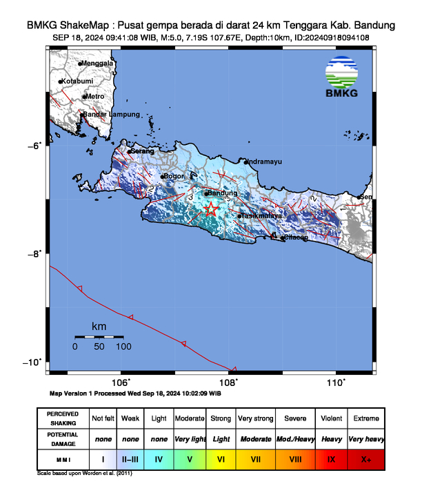
One person killed and two others injured by a falling tree. [51] [52] Fourteen homes and a mosque damaged, and ground cracks appeared in the Subang area. [53] | 1 | 2 |
Strongest magnitude | 6.9 Mw Papua New Guinea |
---|---|
Deadliest | 6.9 Mw Papua New Guinea 5 deaths |
Total fatalities | 6 |
Number by magnitude | |
9.0+ | 0 |
8.0–8.9 | 0 |
7.0–7.9 | 0 |
6.0–6.9 | 9 |
5.0–5.9 | 115 |
4.0–4.9 | 976 |
Date | Country and location | Mw | Depth (km) | MMI | Notes | Casualties | |
---|---|---|---|---|---|---|---|
Dead | Injured | ||||||
3 [54] | Macquarie Island region | 6.8 | 23.2 | - | - | - | - |
4 [55] | Kyrgyzstan, Issyk-Kul, 29 km (18 mi) north-northwest of Cholpon-Ata | 5.3 | 10.0 | VI | One person injured [56] and many buildings damaged in Almaty, Kazakhstan. [57] | - | 1 |
4 [58] | Turkey, Çanakkale, 21 km (13 mi) northeast of Hamdibey | 4.3 | 15.0 | IV | One person killed after jumping from a building in Nilüfer. [59] | 1 | - |
5 [60] | Macquarie Island region | 6.1 | 10.0 | - | Aftershock of the 6.8 earthquake two days prior. | - | - |
8 [61] | Philippines, Davao offshore, 98 km (61 mi) southeast of Pondaguitan | 6.0 | 125.0 | IV | - | - | - |
12 [62] | Peru, Huancavelica, 32 km (20 mi) north northeast of Pampas | 4.0 | 24.0 | - | One home collapsed and 49 structures damaged in the Tayacaja area. [63] | - | - |
13 [64] | Papua New Guinea, West New Britain, 68 km (42 mi) east-southeast of Kimbe | 6.0 | 44.0 | VI | - | - | - |
14 [65] | northern Mid-Atlantic Ridge | 6.0 | 10.0 | - | - | - | - |
21 [66] | India, Maharashtra, 20 km (12 mi) south southwest of Kalamnuri | 4.6 | 10.0 | V | Many homes collapsed and many others damaged in the Nanded area. [67] | - | - |
22 [68] | Indonesia, East Java offshore, 118 km (73 mi) north of Paciran | 5.6 | 10.0 | VII | Ten people hospitalized after suffering panic attacks, another injured by falling debris, two houses and a village hall destroyed, and 35 structures damaged in Bawean. [69] [70] [71] [72] [73] | - | 11 |
22 [74] | Indonesia, East Java offshore, 111 km (69 mi) north of Paciran | 6.4 | 8.5 | VIII | Four people injured, [75] [76] [77] 774 houses destroyed [78] and 4,858 structures damaged in the Bawean-Tuban-Surabaya area. [79] | - | 4 |
23 [80] | Indonesia, Bengkulu offshore, 82 km (51 mi) southwest of Pagar Alam | 5.3 | 60.9 | V | Eight homes collapsed and 110 structures damaged in South Bengkulu Regency. [81] | - | - |
23 [82] | Papua New Guinea, East Sepik, 38 km (24 mi) east-northeast of Ambunti | 6.9 | 40.2 | VIII | 5 | 2+ | |
27 [83] | Vanuatu region | 6.4 | 10.0 | IV | - | - | - |
29 [84] | Greece, Peloponnese offshore, 30 km (19 mi) northwest of Filiatra | 5.8 | 25.5 | V | Several old homes collapsed and many buildings and bridges damaged in the Zacharo area. [85] | - | - |
Strongest magnitude | 7.4 Mw Taiwan |
---|---|
Deadliest | 7.4 Mw Taiwan 18 deaths |
Total fatalities | 18 |
Number by magnitude | |
9.0+ | 0 |
8.0–8.9 | 0 |
7.0–7.9 | 1 |
6.0–6.9 | 13 |
5.0–5.9 | 154 |
4.0–4.9 | 819 |
Date | Country and location | Mw | Depth (km) | MMI | Notes | Casualties | |
---|---|---|---|---|---|---|---|
Dead | Injured | ||||||
1 [86] | Japan, Iwate, 7 km (4.3 mi) southwest of Kuji | 5.9 | 72.9 | V | Two people injured in Aomori Prefecture and several structures damaged in the Kuji area. [87] [88] | - | 2 |
2 [89] | Northern Mariana Islands, Saipan offshore, 136 km (85 mi) east-northeast of Saipan | 6.2 | 10.0 | IV | - | - | - |
2 [90] | Taiwan, Hualien offshore, 16 km (9.9 mi) south of Hualien City | 7.4 | 40.0 | VIII | 18 | 1,145 | |
3 [91] | Taiwan, Hualien offshore, 11 km (6.8 mi) northeast of Hualien City | 6.4 | 12.6 | VII | Aftershock of the 7.4 earthquake 13 minutes prior. | - | - |
4 [92] | Japan, Fukushima, 83 km (52 mi) east of Minami-Sōma | 6.1 | 40.1 | IV | - | - | - |
5 [93] | Northern Mariana Islands, Maug Islands offshore | 6.8 | 222.0 | IV | - | - | - |
6 [94] | China, Yunnan, 25 km (16 mi) west southwest of Zhaotong | 5.0 | 10.0 | IV | Two barns collapsed and rockfalls occurred in Ludian County. [95] | - | - |
9 [96] | Indonesia, West Papua offshore, 35 km (22 mi) east-southeast of Ransiki | 6.0 | 9.1 | VI | - | - | - |
9 [97] | Indonesia, North Maluku offshore, 149 km (93 mi) northwest of Tobelo | 6.4 | 35.0 | IV | - | - | - |
14 [98] | Papua New Guinea, East New Britain, 110 km (68 mi) east-southeast of Kimbe | 6.5 | 49.0 | VI | - | - | - |
17 [99] | Peru, Cusco, 4 km (2.5 mi) east of Oropesa | 4.0 | 15.0 | - | Several homes collapsed, 648 structures damaged and landslides blocked roads in the Lucre area. [100] | - | - |
17 [101] | Japan, Ehime offshore, 17 km (11 mi) west southwest of Uwajima | 6.3 | 25.7 | VIII | Sixteen people injured, 10 homes damaged, power poles toppled, landslides reported and water pipes damaged in Ōita, Ehime, Hiroshima and Kōchi Prefectures. [102] [103] [104] A reactor fitting at the Ikata Nuclear Power Plant fell off. [105] | - | 16 |
18 [106] | Turkey, Tokat, 9 km (5.6 mi) west of Sulusaray | 5.6 | 10.0 | VII | Five people injured, [107] 20 houses and two minarets destroyed [108] and 283 buildings damaged in Tokat Province. [109] One building collapsed [110] and 169 others damaged in Yozgat Province. [111] | - | 5 |
22 [112] | Taiwan, Hualien offshore, 28 km (17 mi) south of Hualien City | 6.1 | 10.7 | VII | Aftershocks of the 2024 Hualien earthquake. Five buildings destroyed in Hualien County; two in Hualien City, [113] two in Ji'an [114] and another in Shoufeng. [115] | - | - |
22 [116] | Taiwan, Hualien offshore, 13 km (8.1 mi) south-southwest of Hualien City | 6.0 | 10.0 | VIII | - | - | |
27 [117] | Mid-Indian Ridge | 6.0 | 10.0 | IV | - | - | - |
27 [118] | Japan, Bonin Islands offshore | 6.5 | 503.2 | II | - | - | - |
27 [119] | Indonesia, West Java offshore, 102 km (63 mi) south of Banjar | 6.1 | 68.3 | V | Six people injured, [120] 131 homes and 18 buildings damaged in Garut Regency; [121] two people injured, one home collapsed and 22 others damaged in Ciamis Regency; [122] [123] one person injured, five houses collapsed, 18 others, two schools, a hospital and two mosques damaged, and power outages in Tasikmalaya; [124] [125] [126] one home destroyed and 17 others damaged in Sukabumi; [125] [127] 24 houses damaged in Bandung. [125] | - | 9 |
The 2017 Java earthquake occurred on 15 December 2017 when a moment magnitude 6.5 earthquake struck the Indonesian island of Java, specifically the city of Tasikmalaya on 23:47:58 West Indonesian Time in West Java, Indonesia. The earthquake struck at a depth of 91 km and was categorized as a strong but deep earthquake. It was initially registered as a 7.3 magnitude earthquake by Indonesian agencies. Widespread damage was reported across Tasikmalaya, the nearest major city to the epicentre. A tsunami warning was immediately issued by the authorities but was subsequently cancelled. Four people have been confirmed dead.
On 23 January 2018, at 13:34:50 Western Indonesian Time, an earthquake struck the Indonesian island of Java near the regency of Lebak. The earthquake, measured 5.9 on the Mww, occurred approximately 40 kilometres south of the village of Binuangeun at a depth of 43.9 kilometres. The earthquake was categorized as a strong and shallow earthquake.
A Mw 6.4 earthquake struck the island of Lombok on the morning of 29 July 2018 at a shallow depth of 14 km (8.7 mi). Widespread damage was reported in the area, and authorities confirmed that 20 people were killed in the earthquake while hundreds were injured.
On 11 October 2018, an earthquake struck off the coast of East Java, Indonesia, with the epicentre located off the coast of Situbondo Regency. The earthquake, which struck at dawn, killing four people in addition to destroying or damaging hundreds of houses, mostly on the small island of Sapudi.
On 17 March 2019, an earthquake measuring Mw 5.6 struck the island of Lombok in West Nusa Tenggara, Indonesia. The earthquake triggered a landslide, killing six and injuring nearly 200 others.
The 2019 North Maluku earthquake, a shallow 7.2 magnitude earthquake, struck the island of Halmahera, North Maluku, Indonesia on 14 July 2019 at 18:10 local time with its epicentre located at South Halmahera. It struck at a shallow depth of 10 km (6.2 mi) near Labuha, a small port town located in Bacan Island. The earthquake produced a non-destructive 20 cm tsunami, which struck Labuha just minutes after the shaking started. 14 people were killed by the earthquake while 129 people were injured, and more than 50,000 people were displaced. The earthquake inflicted a total damage of Rp 238 billion.
The 2019 Sunda Strait earthquake occurred on the night of 2 August 2019, when a magnitude 6.9 earthquake rattled Sunda Strait at a moderate depth of 52.8 kilometres. The epicentre was located 214 km from Bandar Lampung, the capital of Lampung and 147 km west of Sumur, Pandeglang Regency. The earthquake struck with a maximum intensity of VI (Strong). The earthquake prompted a tsunami warning in the area, with authorities urging coastal residents to immediately evacuate to higher grounds.
On 26 September 2019, a strong magnitude 6.5 earthquake struck Seram Island in Maluku, Indonesia, near the provincial capital of Ambon. The earthquake struck at 07:46:44 Eastern Indonesia Time with a shallow depth of 18 km. The tremor could be felt throughout the island, with an intensity of very strong (VII) reportedly felt in the provincial capital of Ambon.
A moment magnitude 6.2 earthquake struck Majene Regency in West Sulawesi, Indonesia, on 15 January 2021, at 02:28 WITA. The reverse faulting shock initiated at 18.0 km (11.2 mi) depth with an epicenter inland, located 32 km (20 mi) south of Mamuju. It was preceded by a Mw 5.7 foreshock several hours prior. Shaking from the mainshock was assigned a maximum Modified Mercalli intensity of VI (Strong) in Majene and Mamuju. Four of the five regencies in West Sulawesi were affected. More than 6,000 structures were damaged or destroyed; damage was estimated at Rp829.1 billion rupiah. At least 105 people were confirmed dead; more than 3,300 were injured and thousands were displaced.
An earthquake occurred on 10 April 2021 at 14:00 local time (UTC+07:00) off the south coast of eastern Java. The epicenter of the earthquake is located 44 km south–southwest of Gondanglegi Kulon in East Java province. Measuring 6.0 or 6.1 on the moment magnitude scale (Mw ) and having a depth of 82.3 km, the earthquake caused moderate shaking measuring V on the Mercalli intensity scale. At least 10 individuals are known to have died from the earthquake and another 104 were seriously injured.
The 2021 Bali earthquake struck at 04:18 local time (UTC+08:00) when people were still sleeping on 15 October 2021. It resulted in 4 deaths and 73 more injured, despite having a moment magnitude of 4.7.
An earthquake occurred 112 km, offshore, north of Maumere in the Flores Sea on 14 December. The quake had a moment magnitude of 7.3 according to the United States Geological Survey (USGS). One person was killed and 173 others suffered injuries.
On 25 February 2022 at 08:39 WIB, a moment magnitude (Mw ) 6.2 earthquake struck West Sumatra, Indonesia at a depth of 4.0 km (2.5 mi). Preceded by one foreshock and followed by over 200 aftershocks, the mainshock had an epicenter at the foot of Mount Talakmau in Pasaman Regency. The mainshock was the result of strike-slip faulting along a previously unidentified segment of the Great Sumatran Fault. At least 27 people died, 457 were injured, and 19,221 others were displaced. It inflicted 780 million Indonesian rupiahs (Rp) worth of damage. The heaviest damage was recorded at three villages around Mount Talakmau. Landslides and flash floods caused additional damage and casualties.
On 21 November 2022, at 13:21 WIB (UTC+07:00), a Mww 5.6 earthquake struck near Cianjur in West Java, Indonesia. The strike-slip earthquake occurred with a focal depth of 11 km (6.8 mi). Between 335 and 635 people died, 7,729 were injured and five remain missing. More than 62,628 homes were damaged across 16 districts in Cianjur Regency and the surrounding region. It is the deadliest earthquake to hit Indonesia since the 2018 Sulawesi earthquake. Damage evaluated after the event earned it a maximum Modified Mercalli intensity of VIII (Severe).
2024 (MMXXIV) is the current year, and is a leap year starting on Monday of the Gregorian calendar, the 2024th year of the Common Era (CE) and Anno Domini (AD) designations, the 24th year of the 3rd millennium and the 21st century, and the 5th year of the 2020s decade.
{{cite news}}
: CS1 maint: unrecognized language (link)