| Pomabamba | |
|---|---|
|   Pomabamba | |
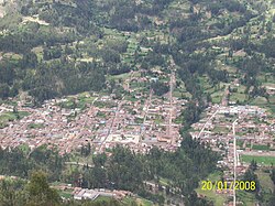
| Location of Pomabamba in the Pomabamba province | |
| Country |  Peru | 
| Region | Ancash | 
| Province | Pomabamba | 
| Founded | February 21, 1861 | 
| Capital | Pumapampa | 
| Government | |
| • Mayor | Julian Watson Cirilo Diestra (2007) | 
| Area | |
|  • Total | 347.92 km2 (134.33 sq mi) | 
| Elevation | 2,948 m (9,672 ft) | 
| Population | |
|  • Total | 14,780 | 
| • Density | 42/km2 (110/sq mi) | 
| Time zone | UTC-5 (PET) | 
| UBIGEO | 021601 | 
| Website | munipomabamba.gob.pe | 
Pomabamba (Quechua Pumaq pampa, pumaq cougar, pampa large plain, [1] "cougar plain") is the largest of 4 districts in the Pomabamba Province of the Ancash Region in Peru. [2]
The people in the district are mainly indigenous citizens of Quechua descent. Quechua is the language which the majority of the population (76.16%) learnt to speak in childhood, 23.62% of the residents started speaking using the Spanish language (2007 Peru Census). [3]
| Climate data for Pomabamba, elevation 2,985 m (9,793 ft), (1991–2020) | |||||||||||||
|---|---|---|---|---|---|---|---|---|---|---|---|---|---|
| Month | Jan | Feb | Mar | Apr | May | Jun | Jul | Aug | Sep | Oct | Nov | Dec | Year | 
| Mean daily maximum °C (°F) | 21.6 (70.9) | 21.3 (70.3) | 20.9 (69.6) | 21.2 (70.2) | 21.9 (71.4) | 21.9 (71.4) | 22.1 (71.8) | 22.5 (72.5) | 22.5 (72.5) | 22.3 (72.1) | 22.7 (72.9) | 21.7 (71.1) | 21.9 (71.4) | 
| Mean daily minimum °C (°F) | 7.3 (45.1) | 7.6 (45.7) | 7.5 (45.5) | 7.4 (45.3) | 6.1 (43.0) | 4.4 (39.9) | 3.9 (39.0) | 4.5 (40.1) | 5.9 (42.6) | 6.8 (44.2) | 7.0 (44.6) | 7.4 (45.3) | 6.3 (43.4) | 
| Average precipitation mm (inches) | 140.9 (5.55) | 133.2 (5.24) | 148.2 (5.83) | 102.7 (4.04) | 40.0 (1.57) | 12.0 (0.47) | 6.8 (0.27) | 10.5 (0.41) | 36.6 (1.44) | 99.7 (3.93) | 91.6 (3.61) | 145.2 (5.72) | 967.4 (38.08) | 
| Source: National Meteorology and Hydrology Service of Peru [4] | |||||||||||||
8°49′59″S77°28′01″W / 8.83306°S 77.46694°W