Ancash is a region of northern Peru. It is bordered by La Libertad Region on the north, Huánuco and Pasco regions on the east, the Lima Region on the south, and the Pacific Ocean on the west. Its capital is the city of Huaraz, and its largest city and port is Chimbote. The name of the region originates from the Quechua word anqash, from anqas (blue) or from anka (eagle).

The Huaylas Province is one of 20 provinces of the Ancash Region in Peru.

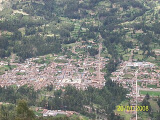
The Pomabamba Province is one of twenty provinces of the Ancash Region in Peru. It was formerly called Pumapampa and today it is also known as "The City of Cedars". It is located at the left bank of the Pomabamba river, at 3,063 meters (10,049 ft) above sea level. It was created by law on February 21, 1861.
Pomabamba is the largest of 4 districts in the Pomabamba Province of the Ancash Region in Peru.

Yuracmarca or Yuraq Marka is one of 10 districts of the Huaylas Province in the Ancash Region of Peru. The capital of the district is the village of Yuracmarca.
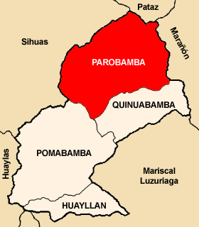
Parobamba District is one of 4 districts in the Pomabamba Province of the Ancash Region in Peru.
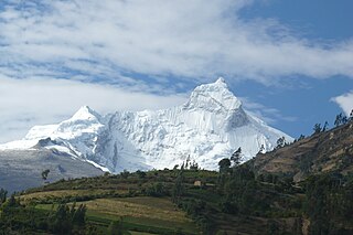
Pucajirca or Pucahirca is a mountain in the Cordillera Blanca in the Andes of Peru, about 6,046 m (19,836 ft) high. It is located in the Ancash Region, Pomabamba Province, Pomabamba District as well as in the Huaylas Province, Yuracmarca District north of Rinrijirca.
Lake Atuncocha, also known as LakeCullicocha (possibly from Quechua kulli a color between blue and carmine is a lake in Peru located in the Ancash Region, Huaylas Province, Santa Cruz District. It is situated at a height of about 4,625 metres, about 1.88 km long and 0.6 km at its widest point. Lake Atuncocha lies in the Cordillera Blanca, northwest of Santa Cruz and Pergarumi, between Lake Rajucocha in the east and Lake Collorcocha in the west.
Lake Ichiccocha or Lake Chica is a lake in the Cordillera Blanca in the Andes of Peru located in Ancash Region, Huaylas Province, Santa Cruz District. It lies within Santa Cruz Creek, between the mountains Pomabamba to the north and Caraz to the south, southwest of the larger lake Jatuncocha.
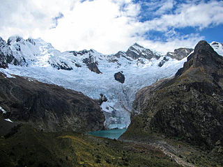
Jatuncocha is a lake in the Cordillera Blanca in the Andes of Peru located in the Ancash Region, Huaylas Province, Santa Cruz District. It is situated at a height of 3,886 m (12,749 ft) comprising an area of 0.486550 km2 (486,550 m2). Jatunccocha lies in the Santa Cruz gorge between the peaks of Quitaraju in the north and Caraz in the south, northeast of a smaller lake named Ichiccocha.
Lauricocha is a lake in the Cordillera Blanca in the Andes of Peru. It is located in the Ancash Region, Asunción Province, Chacas District. Lauricocha lies south-west of the lake Yanacocha, south of Paqarisha Lake and north-east of the mountain Pomabamba.

Carhuascancha or Tumarinaraju is a mountain in the Cordillera Blanca in the Andes of Peru with an elevation of 5,648 metres (18,530 ft) or 5,668 metres (18,596 ft) above sea level. It is situated in the Ancash Region, Huari Province, Huantar District, and in the Huaraz Province, Huaraz District. Carhuascancha lies north-west of Huantsán.

Tuctubamba or Tuqtubamba is a 5,240-metre-high (17,192 ft) mountain in the Cordillera Blanca in the Andes of Peru. It is situated in the Ancash Region, at the border of the Mariscal Luzuriaga Province, Lucma District, the Pomabamba Province, Huayllán District, and the Yungay Province, Yanama District. Tuctubamba lies southeast of Taulliraju.
Pukarahu or Puka Rahu may refer to:
Puka Hirka or Pukahirka may refer to:
Kita Raqsa is a mountain in the Cordillera Blanca in the Andes of Peru which reaches a height of approximately 4,200 m (13,780 ft). It is located in the Ancash Region, Huaylas Province, Yuracmarca District. Kita Raqsa lies northwest of Pilanku.
Hatun Kunka is a mountain in the Cordillera Negra in the Andes of Peru which reaches a height of approximately 4,400 m (14,436 ft). It is located in the Ancash Region, Huaylas Province, Pamparomas District, and in the Yungay Province, Quillo District.
Rocotopunta is a mountain in the Cordillera Blanca in the Andes of Peru which reaches a height of approximately 5,400 m (17,717 ft). It is located in the Ancash Region, Huaylas Province, Caraz District, and in the Yungay Province, Yungay District. Rocotopunta lies west of Huandoy.
Hatun Hirka is a mountain in the Cordillera Negra in the Andes of Peru which reaches a height of approximately 3,400 m (11,200 ft). It is located in the Ancash Region, Huaylas Province, Pamparomas District, and in the Santa Province, Cáceres del Perú District, northwest of Pamparomas.