Caraz District

Last updated
Caraz
Caraz Plaza.jpg
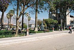
Central plaza of Caraz
Flag of Caraz.svg
Flag
Caras escudo.jpg
Coat of arms
Location of the district Caraz in Huaylas.png
Location of Caraz in the Huaylas province
Country Flag of Peru.svg  Peru
Region Ancash
Province Huaylas
Founded29 December 1856
Capital Caraz
Subdivisions 13
Government
   Mayor Esteban Florentino
Area
  Total246.52 km2 (95.18 sq mi)
Elevation
2,285 m (7,497 ft)
Population
 (2017)
  Total24,128
  Density98/km2 (250/sq mi)
Time zone UTC-5 (PET)
UBIGEO 021201
Website municaraz.gob.pe

The Caraz District (Spanish : Distrito de Caraz) is one of 10 districts of the Huaylas Province in the Ancash Region of Peru. The capital of the district is Caraz. [1] Its elevation is 2,285 m. In Caraz, the paved road comes from Pativilca.

Contents

The snow-capped mountains of Tullparahu (6,356 m), Pukarahu (6,259 m), Allpamayu (6,120 m) and others, constitute a splendid frame for the city. Near Parun Lake the snow summits are reflected. There are also mineral-medicinal springs like Colca and Shongor.

The settlers produce wool textiles, carpets, ponchos, straw fabrics and the renowned fruit and manjarblanco sweets known as cuarteados.

Departing from Caraz to the north, the Santa River is crossed to arrive to the Cañón del Pato. The Callejón de Huaylas has become narrow between the highest and vertical walls of rock, without any vegetation and, in this stretch, the rocks of the Cordillera Blanca and Cordillera Negra come closer (less than 5 m of distance).

To arrive to Huallanca, at the north end of the Callejón de Huaylas, 33 tunnels must be passed in a trip of 25 km, in which the Santa River breaks, roaring, the Cordillera Negra, to flow to the sea.

In Huallanca, 1,410 msnm, the hydroelectric power station of the Cañón del Pato is located. In this place, the highway that goes up to Chimbote began. This highway is planned over the ancient embankment of the railroad Chimbote-Huallanca that was destroyed by a cataclysm in 1970. In this place, it also began the highway that leads to the Callejón de Conchucos.

Geography

The district is located in the south-eastern part of the province at an elevation of 2,285m, 67 km from the regions capital Huaraz.

The Cordillera Blanca traverses the district. Some of the highest mountains of the district are listed below: [2]

History

The district was founded by Don Simón Bolívar on December 29, 1856.

Political division

The Caraz District is divided into 13 hamlets (Spanish : caseríos, singular: caserío) and 6 (Spanish : anexos, singular: anexo):

Hamlets

Annexes

Related Research Articles

Chimbote Place in Ancash, Peru

Chimbote[tʃimˈbote](listen) is the largest city in the Ancash Region of Peru, and the capital of both Santa Province and Chimbote District.

Department of Ancash Departments of Peru

Ancash is a department of northern Peru. It is bordered by the departments of La Libertad on the north, Huánuco and Pasco on the east, Lima on the south, and the Pacific Ocean on the west. Its capital is the city of Huaraz, and its largest city and port is Chimbote. The name of the region originates from the Quechua word anqash, from anqas (blue) or from anka (eagle).

Huaraz City in Ancash, Peru

Huaraz, founded as San Sebastián de Huaraz, is a city in Peru. It is the capital of the Ancash Region and the seat of government of Huaraz Province. The urban area's population is distributed over the districts of Huaraz and Independencia. The city is located in the middle of the Callejon de Huaylas Valley and on the right side of the river Santa. The city has an elevation of approximately 3050 metres above sea level. The built-up area covers 8 km2 and has a population of 120,000 inhabitants, making it the second largest city in the central Peruvian Andes after the city of Huancayo. It is the 22nd largest city in Peru. Huaraz is the seat of the province's Roman Catholic Bishop and the site of the cathedral.

The Santa Valley is an inter-andean valley in the Ancash Region in the north-central highlands of Peru. Due to its location between two mountain ranges, it is known as Callejón de Huaylas, the Alley of Huaylas, whereas "Huaylas" refers to the territorial division's name during the Viceroyalty of Peru.

Santa River river in Peru

The Santa River is a river in the South American Andes mountain range in the Ancash Region of northwest central Peru.

Caraz Town in Ancash, Peru

Caraz is a town in the Caraz District in the southeastern part of Huaylas Province of the Ancash Region in Peru.

Huaraz Province Province in Ancash, Peru

The Huaraz Province is one of twenty provinces of the Ancash Region in Peru. It was created on August 5, 1857 during the presidency of Ramón Castilla. Geographically, the province is located over the Callejón de Huaylas and the western slopes of the Cordillera Negra.

Huaylas Province Province in Ancash, Peru

The Huaylas Province is one of 20 provinces of the Ancash Region in Peru.

Santa Province Province in Ancash, Peru

The Santa Province is one of twenty provinces of the Ancash Region in Peru.

Huata District, Huaylas District in Ancash, Peru

The Huata District is the smallest of the 10 districts of the Huaylas Province in the Ancash Region of Peru. The capital of the district is the village of Huata.

Mato District District in Ancash, Peru

The Mato District is one of 10 districts of the Huaylas Province in the Ancash Region of Peru. The capital of the district is the village of Villa Sucre.

Pamparomas District District in Ancash, Peru

The Pamparomas District is one of 10 districts of the Huaylas Province in the Ancash Region of Peru. The capital of the district is the village of Pamparomas. The district was founded on January 2, 1857.

Pamparomas is a village in the Pamparomas District of the Huaylas Province in the Ancash Region of Peru. It is the capital of the district with the same name: Pamparomas District. According to the Pamparomas research center, the name comes from the "Roma" profile of the surrounding hillsides.

Yuracmarca District District in Ancash, Peru

Yuracmarca or Yuraq Marka is one of 10 districts of the Huaylas Province in the Ancash Region of Peru. The capital of the district is the village of Yuracmarca.

Huallanca District, Huaylas District in Ancash, Peru

The Huallanca District or Wallanka is the most northeastern of the 10 districts that comprise Huaylas Province in the Ancash Region of Peru. It is in the high mountain range known as Cordillera Negra. The district capital is Huallanca. The district was founded in 1950 by separating it from the Huaylas District.

Yungay District District in Ancash, Peru

Yungay district is a district in the Province of Yungay in the Ancash region, Peru. It was created by law on October 28, 1904.

Santa Cruz District, Ancash District in Ancash, Peru

The Santa Cruz District is one of 10 districts of the Huaylas Province in the Ancash Region of Peru. The capital of the district is Huaripampa.

Cañón del Pato is on the Rio Santa at the north end of the Callejón de Huaylas in north-central Peru. The mostly rocky canyon walls are too steep and arid for cultivation, and in only a few places are the slopes of the imposingly rugged canyon suitable even for grazing domestic animals. The canyon was formed by the river where the north end of the Cordillera Negra range converges with the Cordillera Blanca mountain range. These two Andean ridges run generally parallel for nearly 140 km from south of the city of Huaraz northward to the Cañón; the Cordillera Blanca continues northward for another hundred kilometers or more. The Callejón de Huaylas is the valley between the two cordilleras averaging about 16 km in width but in places as much as 25 km in width.

Coñocranra mountain in Peru

Coñocranra is a mountain of Peru located in the Ancash Region, Santa Province. It is the highest mountain in the Cordillera Negra at.

Carhuascancha mountain in Peru

Carhuascancha or Tumarinaraju is a mountain in the Cordillera Blanca in the Andes of Peru with an elevation of 5,648 metres (18,530 ft) or 5,668 metres (18,596 ft) above sea level. It is situated in the Ancash Region, Huari Province, Huantar District, and in the Huaraz Province, Huaraz District. Carhuascancha lies north-west of Huantsán.

References

  1. Official web site of the Huaylas province
  2. escale.minedu.gob.pe - UGEL map of the Huaylas Province (Ancash Region)

Caraz Peru

Coordinates: 9°03′00″S77°48′36″W / 9.05000°S 77.81000°W / -9.05000; -77.81000