Ancash is a region of northern Peru. It is bordered by La Libertad Region on the north, Huánuco and Pasco regions on the east, the Lima Region on the south, and the Pacific Ocean on the west. Its capital is the city of Huaraz, and its largest city and port is Chimbote. The name of the region originates from the Quechua word anqash, from anqas (blue) or from anka (eagle).

The Huaylas Province is one of 20 provinces of the Ancash Region in Peru.
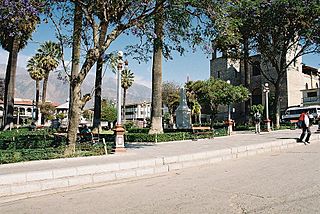
The Caraz District is one of 10 districts of the Huaylas Province in the Ancash Region of Peru. The capital of the district is Caraz. It's elevation is 2,285 m. In Caraz, the paved road comes from Pativilca.

The Santa Cruz District is one of 10 districts of the Huaylas Province in the Ancash Region of Peru. The capital of the district is Huaripampa.
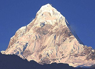
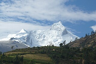
Santa Cruz, Pucaraju, Pukaraju or Pico de Huaylas is a mountain in the Cordillera Blanca in the Andes of Peru; within Santa Cruz District, Huaylas Province, Ancash. It has a height of 6,259 metres (20,535 ft), although other maps cite a height of 6,241 metres (20,476 ft).
Rinrijirca is a mountain in the Cordillera Blanca in the Andes of Peru, about 5,810 m (19,836 ft) high. It is located in the Ancash Region, Huaylas Province, Santa Cruz District south of Pucajirca.
Sentilo is a 5,100-metre-high (16,700 ft) mountain in the Cordillera Blanca in the Andes of Peru. It is located in Ancash Region, Huaylas Province, Santa Cruz District. Sentilo lies at the Punta Unión pass, the highest point of the Santa Cruz valley, south of the mountains Rinrijirca and Pucajirca, southwest of Taulliraju, and northeast of mountains Artesonraju and Parón.

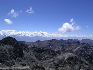
Caraz or Carás is a mountain in the Cordillera Blanca in the Andes of Peru, about 6,025 metres (19,767 ft) high. It is located in the Ancash Region, Huaylas Province, in the districts Caraz and Santa Cruz District. This peak is inside Huascarán National Park, most precisely southwest of Artesonraju, northwest of Pirámide, north of Lake Parón and south of Santa Cruz Creek.
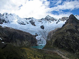
Lake Ichiccocha or Lake Chica is a lake in the Cordillera Blanca in the Andes of Peru located in Ancash Region, Huaylas Province, Santa Cruz District. It lies within Santa Cruz Creek, between the mountains Pomabamba to the north and Caraz to the south, southwest of the larger lake Jatuncocha.
Jatuncocha is a lake in the Cordillera Blanca in the Andes of Peru located in the Ancash Region, Huaylas Province, Santa Cruz District. It is situated at a height of 3,886 m (12,749 ft) comprising an area of 0.486550 km2 (486,550 m2). Jatunccocha lies in the Santa Cruz gorge between the peaks of Quitaraju in the north and Caraz in the south, northeast of a smaller lake named Ichiccocha.

Pilanco is a mountain in the north of the Cordillera Blanca in the Andes of Peru, about 5,286 metres (17,343 ft) high. It is located in Yuracmarca District, Huaylas Province, Ancash. Pilanco lies northeast of Santa Cruz, northwest of Alpamayo and east of Millwaqucha. Los Cedros Creek flows along its southern slopes, receiving the name Alpamayo in that section.
Quitaraju or Kitaraju is a mountain in the Cordillera Blanca in the Andes of Peru, about 6,040 metres (19,816 ft) high. It is situated in the Ancash Region, Huaylas Province, Santa Cruz District. Quitaraju lies north of the Santa Cruz Creek and the lakes named Ichiccocha, Jatuncocha and Quitacocha, between Santa Cruz in the west and Alpamayo in the northeast.
Taullicocha or Tawlliqucha is a lake in the Cordillera Blanca in the Andes of Peru located in the Ancash Region, Huaylas Province, Santa Cruz District. It is situated at a height of 4,426 m (14,521 ft) comprising an area of 0.133766 km2 (133,766 m2). Taullicocha lies southeast of Pucajirca and southwest of Taulliraju.
Kushuru is a mountain in the northern part of the Cordillera Negra in the Andes of Peru, about 5,000 m (16,000 ft) high. It is situated in the Ancash Region, Huaylas Province, Santo Toribio District, and in the Santa Province, Cáceres del Perú District. Kushuru lies between Yana Yaku in the southeast and Quñuqranra in the northwest, east of Ichik Wiri.
Pergarumi or Pirqa Rumi is a mountain in the northern part of the Cordillera Blanca in the Andes of Peru which reaches a height of approximately 5,000 m (16,404 ft). It is located in the Ancash Region, Huaylas Province, Santa Cruz District. Pergarumi lies northwest of Santa Cruz, south of the lakes Atuncocha and Rajucocha.
Tawlli Qaqa is a mountain in the Cordillera Blanca in the Andes of Peru which reaches a height of approximately 4,800 m (15,700 ft). It is located in the Ancash Region, Huaylas Province, Santa Cruz District. Tawlli Qaqa lies at the Yuraqmayu valley south of Kitarahu, southwest of Kitaqucha and northwest of Hatunqucha.
Santa Cruz Norte is a mountain in the Cordillera Blanca in the Andes of Peru; within Santa Cruz District, Huaylas Province, Ancash. It has a height of 5,829 metres (19,124 ft).
Santa Cruz Chico, is a mountain in the Cordillera Blanca in the Andes of Peru; within Santa Cruz District, Huaylas Province, Ancash. It has a height of 5,800 metres (19,029 ft).
Yuraqqucha is a lake in the Cordillera Blanca in the Andes of Peru. It is situated at a height of 4,618 m (15,151 ft) comprising an area of 0.287268 km2 (287,268 m2). Pukaqucha is located in the Ancash Region, Huaylas Province, Santa Cruz District, northwest of the peak of Pukarahu.