Alpamayo

Last updated
Alpamayo
Alpamayo 12.jpg
Highest point
Elevation 5,947 m (19,511 ft)
Prominence 447 m (1,467 ft) [1]
Parent peak Quitaraju
Coordinates 08°52.75′S77°39.22′W / 8.87917°S 77.65367°W / -8.87917; -77.65367
Naming
Native nameShuyturaju (Quechua)
Geography
Peru physical map.svg
Red triangle with thick white border.svg
Alpamayo
Peru
Location Ancash, Peru
Parent range Cordillera Blanca
Climbing
First ascent June 20, 1957, by Günter Hauser, Berhard Huhn and Horst Wiedmann.
Easiest route Difficult snow/ice climb on SW face

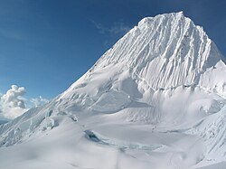
Alpamayo [2] [3] (possibly from Quechua allpa earth, mayu river, [4] "earth river") or Shuyturaju [3] (possibly from Ancash Quechua huytu, shuytu oblong, slim and long, Quechua rahu snow, ice, mountain covered in snow) [5] [6] is one of the most conspicuous peaks in the Cordillera Blanca of the Peruvian Andes. Alpamayo Creek originates northwest of it. [2]

Contents

The Alpamayo lies next to the slightly higher Quitaraju.

In July 1966, the German magazine "Alpinismus", published a photo of Alpamayo taken by American photographer Leigh Ortenburger accompanied by an article on a survey among mountaineering experts, who chose Alpamayo as "The Most Beautiful Mountain in the World". [7]

Climbing history and routes

Climbers on Alpamayo in 2003 Alpamayo.jpg
Climbers on Alpamayo in 2003

Most popular routes start from the village of Caraz, on the north of the Cordillera Blanca. A French-Belgian expedition including George and Claude Kogan claimed to have made the first ascent in 1951. After studying the photos in George Kogan's book The Ascent of Alpamayo, the German team of G. Hauser, F. Knauss, B. Huhn & H. Wiedmann came to the conclusion that the 1951 team did not reach the actual summit, thereby making their ascent via the north ridge in 1957 the first.

The most common climbing route, known as the Ferrari route, is situated on the southwest face of the mountain. It was opened in 1975 by a group of Italian alpinists led by Casimiro Ferrari. It is considered a difficult climb, demanding good crampon and ice climbing technique. There are incomparable views of steep ice faces, penitentes, gigantic white walls and ridges like those of Huandoy Norte, Artesonraju and Huascaran Norte, similar to the finest of the Himalayan scenery. There are also at least six other alternative climbing routes, the second most popular being the Vasque-French route.

Related Research Articles

<span class="mw-page-title-main">Department of Ancash</span> Departments of Peru

Ancash is a department and region in western Peru. It is bordered by the departments of La Libertad on the north, Huánuco and Pasco on the east, Lima on the south, and the Pacific Ocean on the west. Its capital is the city of Huaraz, and its largest city and port is Chimbote. The name of the region originates from the Quechua word anqash, from anqas ('blue') or from anka ('eagle').

<span class="mw-page-title-main">Huascarán</span> Mountain in Peru

Huascarán, Nevado Huascarán or Mataraju is a mountain in the Peruvian province of Yungay, situated in the Cordillera Blanca range of the western Andes. The southern summit of Huascarán, which reaches 6,768 metres (22,205 ft), is the highest point in Peru, the northern Andes, and in all of the earth's Tropics. Huascarán is the 4th highest mountain in the Western Hemisphere and South America after Aconcagua, Ojos del Salado, and Monte Pissis, respectively. Huascarán is ranked 25th by topographic isolation.

<span class="mw-page-title-main">Illimani</span> Mountain in Bolivia

Illimani is the highest mountain in the Cordillera Real of western Bolivia. It lies near the cities of El Alto and La Paz at the eastern edge of the Altiplano. It is the second highest peak in Bolivia, after Nevado Sajama, and the eighteenth highest peak in South America. The snow line lies at about 4,570 metres (15,000 ft) above sea level, and glaciers are found on the northern face at 4,983 m (16,350 ft). The mountain has four main peaks; the highest is the south summit, Nevado Illimani, which is a popular ascent for mountain climbers.

<span class="mw-page-title-main">Palcaraju</span> Mountain in Peru

Palcaraju is a mountain in the Cordillera Blanca mountain range in the region of Ancash within the Peruvian Andes. It has an elevation of 6,274 metres (20,584 ft) on its main summit.

<span class="mw-page-title-main">Pisco (mountain)</span> Mountain in Peru

Pisco is a mountain in Peru, located in the Cordillera Blanca about 60 km north of Huaraz. It was first climbed on July 12, 1951 by C. Kogan, G. Kogan, R.Leininger and M. Lenoir.

<span class="mw-page-title-main">Salcantay</span> Mountain in Peru

Salcantay, Salkantay or Sallqantay is the highest peak in the Vilcabamba mountain range, part of the Peruvian Andes. It is located in the Cusco Region, about 60 km (40 mi) west-northwest of the city of Cusco. It is the 38th-highest peak in the Andes and the twelfth-highest in Peru. However, as a range highpoint in deeply incised terrain, it is the second most topographically prominent peak in the country, after Huascarán.

<span class="mw-page-title-main">Chopicalqui</span> Mountain in Peru

Chopicalqui or Chopicallqui is a mountain in the Cordillera Blanca area in the Andes of Peru. With a summit elevation of 6,354 metres (20,846 ft) above sea level it is one of the highest peaks of the Cordillera Blanca. It lies in Yungay Province, Ancash, between the mountains Huascarán and Contrahierbas.

<span class="mw-page-title-main">Huandoy</span> Mountain in Peru

Huandoy or Tullparaju is a mountain located inside Huascarán National Park in Ancash, Peru. It is the second-tallest peak of the Cordillera Blanca section of the Andes, after Huascarán. These two peaks are rather nearby, separated only by the Llanganuco glacial valley at 3,846 m asl.

<span class="mw-page-title-main">Huantsán</span> Mountain in Peru

Huantsán,Huantsan or Tunsho is a mountain in the Andes of Peru. It is located in Ancash Region and is part of the Cordillera Blanca mountain range, a sub-range of the Andes. It has four peaks, with a maximum elevation of 6,369 metres (20,896 ft) above sea level.

<span class="mw-page-title-main">Copa (mountain)</span> Mountain in Peru

Nevado Copa is a mountain in the Andes of Peru whose summit reaches about 6,188 metres (20,302 ft) above sea level. It is situated in the Ancash Region, Asunción Province, Chacas District, and in the Carhuaz Province, Marcará District, south-east of Hualcán. Its territory is within the Peruvian protection area of Huascarán National Park and is part of the Cordillera Blanca.

<span class="mw-page-title-main">Rasac</span> Mountain in Peru

Rasac is a mountain in the Huayhuash mountain range in west central Peru, part of the Andes. It has a summit elevation of 6,017 metres (19,741 ft), although other sources cite a height of 6,040 metres (19,816 ft). Rasac is a long, relatively squat mountain on the western edge of the Huayhuash range, across the glacier from the tallest peak in the range, Yerupajá. Although it is a 6,000 metre mountain, Rasac's broad profile is dwarfed by Yerupajá.

<span class="mw-page-title-main">Tuco (mountain)</span> Mountain in Peru

Tuco,Tuku,Tucu or Huanaco Punta is a mountain in the Andes in South America. Its summit is 5,479 m (17,976 ft)) high and it is one of the southernmost peaks in the snow-capped Cordillera Blanca in northwestern central Peru. Tuco is located in the Ancash Region, Bolognesi Province, Aquia District and in the Recuay Province, Catac District. It is situated northeast of Caullaraju, between Challhua in the west and Pastoruri in the east.

<span class="mw-page-title-main">Chacraraju</span> Mountain in the Andes of Peru

Chacraraju or Chakraraju is a mountain in the Cordillera Blanca range in the Andes of Peru. The mountain has two distinctive peaks: Chacraraju Oeste and Chacraraju Este. Chacraraju is located in Huaylas Province, Ancash; south and southeast of Pirámide and east of Lake Parón. The peak is accessible from the Pisco base camp at Cebollapampa.

<span class="mw-page-title-main">Pucajirca</span> Mountain in Peru

Pucajirca or Pucahirca is a mountain in the Cordillera Blanca in the Andes of Peru, about 6,046 m (19,836 ft) high. It is located in the Ancash Region, Pomabamba Province, Pomabamba District as well as in the Huaylas Province, Yuracmarca District north of Rinrijirca. Its slopes are within Huascarán National Park.

<span class="mw-page-title-main">Ranrapalca</span> Mountain in Peru

Ranrapalca is a mountain in the Cordillera Blanca range in the Andes of Peru. It has an elevation of 6,162 m (20,217 ft). It is located in the region of Ancash, east of Ocshapalca. Its territory is within Huascarán National Park, province of Huaraz, within the territory of the local communes Independencia and Tarica.

<span class="mw-page-title-main">Tocllaraju</span> Mountain in Peru

Tocllaraju is a mountain in the Cordillera Blanca in the Andes of Peru, about 6,034 m (19,797 ft) high. It is situated in the Ancash Region, Carhuaz Province, Aco District, and in the Huaraz Province, Tarica District. Its territory is within the Peruvian protection area of Huascarán National Park. Tocllaraju lies north-west of the mountains Pukaranra and Palcaraju.

<span class="mw-page-title-main">Pirámide (mountain)</span> Mountain in Peru

Pirámide, also called Pirámide de Garcilaso or Pirámide de Garcilazo, is a mountain in the Cordillera Blanca in the Andes of Peru, about 5,885 metres (19,308 ft) high. It is located in the Ancash Region, Huaylas Province, Caraz District as well as in the Yungay Province, Yanama District. Pirámide lies inside Huascarán National Park, southeast of Caraz and Artesonraju and north of Chacraraju, at the very end of the Lake Parón valley.

Pilanco is a mountain in the north of the Cordillera Blanca in the Andes of Peru, about 5,286 metres (17,343 ft) high. It is located in Yuracmarca District, Huaylas Province, Ancash. Pilanco lies northeast of Santa Cruz, northwest of Alpamayo and east of Millwaqucha. Los Cedros Creek flows along its southern slopes, receiving the name Alpamayo in that section.

Pucaraju or Pukaraju is a mountain in the Cordillera Blanca in the Andes of Peru, about 5,025 metres (16,486 ft) high. It is situated in the Ancash Region, Mariscal Luzuriaga Province, Lucma District, in the Pomabamba Province, Llumpa District, and in the Yungay Province, Yanama District. Pucaraju lies southeast of Taulliraju and west of the lakes named Wiqruqucha and Orgoncocha.

<span class="mw-page-title-main">Quitaraju</span> Mountain in Peru

Quitaraju or Kitaraju is a mountain in the Cordillera Blanca in the Andes of Peru, about 6,036 metres (19,803 ft) high. It is situated in the Ancash Region, Huaylas Province, Santa Cruz District. Quitaraju lies north of the Santa Cruz Creek and the lakes named Ichiccocha, Jatuncocha and Quitacocha, between Santa Cruz in the west and Alpamayo in the northeast. Its slopes are within the Huascarán National Park.

References

  1. Peakbagger - Alpamayo
  2. 1 2 Peru 1:100 000, Corongo (18-h). IGN (Instituto Geográfico Nacional - Perú). Nevado Alpamayo
  3. 1 2 "Nevado Alpamayo". Inventario Turístico del Perú (in Spanish). MINCETUR. Archived from the original on 10 June 2016. Retrieved 25 May 2016.
  4. Teofilo Laime Ajacopa, Diccionario Bilingüe Iskay simipi yuyayk'ancha, La Paz, 2007 (Quechua-Spanish dictionary)
  5. homepage.ntlworld.com/robert_beer Archived 2016-03-04 at the Wayback Machine Robert Beér, Armando Muyolema, Dr. Hernán S. Aguilar, Vocabulario comparativo, quechua ecuatoriano - quechua ancashino - castellano - English, Brighton 2006
  6. "babylon.com". Archived from the original on 2014-12-29. Retrieved 2013-09-16.
  7. Hibbert, Ian (2015). Alpamayo to Everest: It's Not About the Summit. Lulu Press. ISBN   9781483440736.