| Pamparomas Pamparumas | |
|---|---|
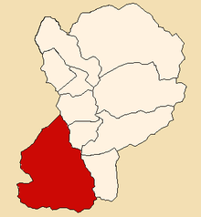
|   Location of Pamparomas in the Huaylas province | |
| Country |  Peru | 
| Region | Ancash | 
| Province | Huaylas | 
| Founded | January 2, 1857 | 
| Capital | Pamparomas | 
| Subdivisions | 43 hamlets | 
| Government | |
| • Mayor | Adrián Palmadera Milla (2012) | 
| Area | |
|  • Total | 496.35 km2 (191.64 sq mi) | 
| Elevation | 2,862 m (9,390 ft) | 
| Population  (2002 est.) | |
|  • Total | 9,484 | 
| • Density | 19/km2 (49/sq mi) | 
| Time zone | UTC-5 (PET) | 
| UBIGEO | 021206 | 
| Website | munipamparomas.gob.pe | 
The Pamparomas District is one of 10 districts of the Huaylas Province in the Ancash Region of Peru. The capital of the district is the village of Pamparomas. [1] The district was founded on January 2, 1857.
The district is located in the south-western part of the province at an elevation of 2,862m in the Cordillera Negra (Spanish for black mountain range). The capital of the province, Caraz, is located at a distance of 80 km. The nearest large city is Chimbote, located on the pacific coast at a distance of 140 km from Pamparomas.
One of the highest peaks of the district is Simiyuq Wank'a at approximately 4,600 m (15,100 ft). Other mountains are listed below: [2]
The district is divided into 43 hamlets (Spanish : caseríos, singular: caserío):
| Pamparomas Valley
 | Chaclancayo Valley
 | Pisha Valley
 | 
The people in the district are mainly indigenous citizens of Quechua descent. Quechua is the language which the majority of the population (81.62%) learnt to speak in childhood, 18.19% of the residents started speaking using the Spanish language (2007 Peru Census). [3]
9°04′12″S77°58′48″W / 9.07000°S 77.98000°W