
Alibag, also known as Alibaug, is a coastal city and a municipal council in Raigad district of Maharashtra, India. It is the headquarters of the Raigad district and is south of the city of Mumbai. Alibag is part of the Mumbai Metropolitan Region and is situated at a distance of about 96 km from Mumbai and 143 km from Pune.

Bhandara District is an administrative district in the state of Maharashtra in India. The name Bhandara is a corruption of Bhanara. Reference to Bhanara is found in an inscription of 1100 A.D. traced at Ratanpur. The district headquarters are located at Bhandara. The district occupies an area of 3717 km2 and has a population of 1,200,334, of which 19.48% are urban as of 2011. The growth rate of Bhandara is 5.56% Bhandara has a mixed economy with agriculture, industries and forest resources. Bhandara is known for its large production of rice. Tumsar, a tahsil town, is a noted rice market. Bhandara town is also known as "Brass City" owing to the presence of a large brass products industry. Bhandara has several tourist destinations, like Ambagad Fort, Brahmi, Chinchgad, and Dighori.
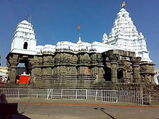
Hingoli district is an administrative district in the state of Maharashtra in India. The district is headquartered at Hingoli. The district occupies an area of 4,526 km2 and has a population of 11,77,345 of which 15.60% were urban. Hingoli was actually known as the Nizams military base as it was bordered with Vidharbha. In that era military troops, hospitals, veterinary hospital were in operation from Hingoli. Being a military base the city was one of the important and famous places of the Hyderabad state. One of the twelve Jyotirlinga shrines, the Aundha Nagnath is located in Hingoli district about 25 km south-west from district headquarter.

Nayagarh district is one of the 30 districts of Odisha state in eastern India. It was created in 1st April 1993 when the erstwhile Puri District was split into three distinct districts, namely Khordha, Nayagarh and Puri.

Chandauli district is a district of Uttar Pradesh state of India, and Chandauli town is the district headquarters. Chandauli district, a part of Varanasi Division, became a separate district on 20 May 1997.

Jalpaiguri district is a district of the Indian state of West Bengal. The district was established in 1869 during British Raj. The headquarters of the district are in the city of Jalpaiguri, which is also the divisional headquarters of Jalpaiguri division.

Vellore district is one of the 38 districts in the Tamil Nadu state of India. It is one of the eleven districts that form the north region of Tamil Nadu. Vellore city is the headquarters of this district. As of 2011, the district had a population of 1,614,242 with a sex ratio of 1,007 females for every 1,000 males. In 2017 Vellore district ranked eleventh in list of districts in Tamil Nadu by Human Development Index.

Wardha District is in the state of Maharashtra in western India. This district is a part of Nagpur Division. The city of Wardha is the administrative headquarter of the district. Hinganghat, Pulgaon, Arvi and Wardha are the major cities in the District. The District had a population of 1,300,774, of which 26.28% were urban as of 2011.
Jalgaon district is a district in Maharashtra, India. Its headquarters is the Jalgaon city.

Sangli district is a district of Maharashtra state in India. Sangli city is the district headquarters. It is bordered by Satara district, Solapur district to the North, Karnataka state to the South-East, by Kolhapur district to South-West and by narrow portion on the East side to Ratnagiri district. It is present on the southern tip of Maharashtra.
Ajara is a census town and the headquarters of Ajara Taluka in the Kolhapur district of Maharashtra, India. It is a developing city with a Nagar Panchayat.

Kantilo is a town and Notified Area Council in Nayagarh district in the Indian state of Odisha. It is a holy place famous for "Lord Nilamadhab". It is an important commercial place in district of Nayagarh. It is also famous for its hand crafted utensils and other materials.
Lasalgaon is a census town in Nashik District in the Indian state of Maharashtra.
Kuttiattoor is a census town in Taliparamba taluk of Kannur district in the Indian state of Kerala. Kuttiattoor is located 26 km (16 mi) north east of District headquarters Kannur and 6.5 km (4.0 mi) south east of Mayyil.

Basmath is one of the 288 constituencies of the Maharashtra Legislative Assembly, in Maharashtra, India.
Alibag taluka is a subdistrict/upazila/tehsil in Raigad district of the Indian state of Maharashtra.
Sirarakhong also called as Kampha is a village located west of Ukhrul in Ukhrul district, Manipur state, India. As per 2011 census, the village has a total of 202 households with 1243 persons of which 620 are male while 623 are female. Of the total population, 10.86% are in the age group of 0–6 years. The average sex ratio of the village is 1015 female per 1000 male which is higher than the state's average of 930. The literacy rate of the village is 95.22%.
Waigaon Turmeric is a variety of Turmeric mainly grown in the Indian state of Maharashtra. It is a common and widely cultivated crop in the village of Waigaon located in Samudrapur taluka of Wardha district. It is also grown in other villages of Samudrapur taluka, including Muradpur, Pawangaon, Mangrul, and Dongargaon.
Sangli turmeric is a variety of turmeric mainly grown in the Indian state of Maharashtra. It is a common and widely cultivated crop in Sangli district. Turmeric cultivation is prominent in the southern region of Sangli, specifically in the areas of Miraj, Tasgaon, Palus, Kadegaon, Walwa, Vita, Khanapur, and Chinchali. Sangli accounts for nearly 70 per cent of the state’s total production and stands as the premier trading hub for turmeric in Asia, and possibly globally. The district has garnered the nickname "Saffron City" due to its strong association with turmeric.
Vasmat Haldi is a variety of turmeric mainly grown in the Indian state of Maharashtra. It is a common and widely cultivated crop in Hingoli district of the Marathwada region of Maharashtra. Turmeric cultivation is prominent in the districts of Hingoli, Parbhani, Nanded, Washim and Akola. Hingoli district has the largest area under turmeric cultivation in this region.

