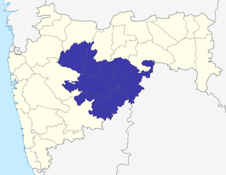
Marathwada is a proposed state and geographical region of the Indian state of Maharashtra. It was formed during the Nizam's rule and was part of the then Hyderabad State. The region coincides with the Aurangabad division of Maharashtra. It borders the states of Karnataka and Telangana, and it lies to the west of the Vidarbha and east of Uttar Maharashtra regions of Maharashtra. The largest city of Marathwada is Aurangabad. Its people speak Marathi and Deccani Urdu.

Buldhana district is located in the Amravati division of Maharashtra, India. It is situated at the western border of Vidarbha region and is 500 km away from the state capital, Mumbai. The district has towns and cities like deulghat, dhad, mehakar, Shegaon, Malkapur, Khamgaon, Lonar and Chikhli. It is surrounded by Madhya Pradesh in the north, Akola, Washim, and Amravati districts on the east, Jalna district on the south, and Jalgaon and Aurangabad districts on the west. Khamgaon is the largest city in the district.

Nanded is a city in Maharashtra state, India. It is the tenth largest city in the state and the seventy-ninth most populated city in India. It is the second largest city in Marathwada region. It is the district headquarters of Nanded district.
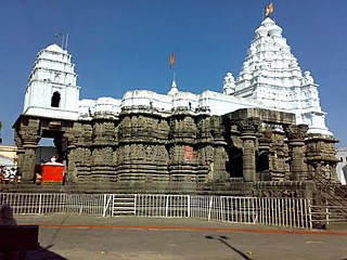
Hingoli district is an administrative district in the state of Maharashtra in India. The district is headquartered at Hingoli. The district occupies an area of 4,526 km2 and has a population of 11,77,345 of which 15.60% were urban. Hingoli was actually known as the Nizams military base as it was bordered with Vidharbha. In that era military troops, hospitals, veterinary hospital were in operation from Hingoli. Being a military base the city was one of the important and famous places of the Hyderabad state. One of the twelve Jyotirlinga shrines, the Aundha Nagnath is located in Hingoli district about 25 km south-west from district headquarter.

Osmanabad District, officially known as Dharashiv District, is an administrative district in the Marathwada region in the Indian state of Maharashtra. The district headquarter is located at Osmanabad. The District of Osmanabad derives its name from the last ruler of Hyderabad, the 7th Nizam, Mir Osman Ali Khan, of which the region was a part till 1947. This region was earlier part of The Hyderabad State until Independence.This primarily rural district occupies an area of 7,569 km2 (2,922 sq mi) of which 241.4 km2 (93.2 sq mi) is urban and has a population of 1,657,576 of which 16.96% were urban.
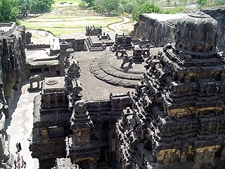
Aurangabad district, officially known as Chhatrapati Sambhaji Nagar district, is one of the 36 districts of the state of Maharashtra in western India. It borders the districts of Nashik to the west, Jalgaon to the north, Jalna to the east, and Ahmednagar to the south. The city of Aurangabad houses the district's administrative headquarters. The district has an area of 10,100 km2, of which 37.55% is urban and the rest is rural. Aurangabad District is a major tourism region in Marathwada, with attractions including the Ajanta Caves and Ellora Caves.

Hingoli is a city and a municipal council in Hingoli district in the Indian state of Maharashtra
Nanded district is a district of Maharashtra state in central India. The city of Nanded is the district headquarters.

Parbhani is a city in Maharashtra state of India. It is the administrative headquarters of Parbhani District. Parbhani is one of the largest cities in Marathwada region. Parbhani is around 200 kilometres (120 mi) away from regional headquarters of Aurangabad while it is 491 km (305 mi) away from the state capital Mumbai.
Pusad is a city in the Yavatmal district located in Vidarbha region of Maharashtra state of India. It is named after the Pus river. Its ancient name was 'Pushpawanti'. Pusad is second largest city of Yavatmal district. For last 20 years Pusad is being tried to be promoted to the stature of district but due to lack of administration of governing bodies it is only a dream of the people.
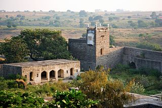
Udgir, is largest city and municipal council in Latur District of the Indian state of Maharashtra. It is located in the Marathwada division of the state. The city is located very close to the borders of Karnataka and Telangana states. Udgir is home to the historical Udgir Fort. The town and nearby villages rely mainly on agriculture, which serves as a major source of income for the population. Udgir city is proposed to be become district.
Morshi is the second largest town in the Amravati district of Maharashtra, India. It is located 55 km north-east of Amravati, situated very close to the border with Madhya Pradesh, in the scenic southern foothills of the Satpura ranges. Morshi and the surrounding region is also known for the cultivation of Nagpur oranges and the prominent Nal Damayanti Dam. Salbardi is very near from morshi.
Partur is a town with municipal council in Jalna district in the Indian state of Maharashtra.
Risod is a city and a municipal council in Washim district in the Indian state of Maharashtra. Risod is also a major market place for the people from Hingoli district as well as Risod tahsil.
Selu also known as Sailu is a city and a municipal council in Parbhani district in the Indian state of Maharashtra.
Mantha is a town in Jalna district in the state of Maharashtra, India.
Siddheshwar Dam is an earth-fill dam on Purna River, which is a tributary of River Godavari. This dam is located in the north-western part of Aundha Nagnath, in the Hingoli district of Maharashtra, India.
Sonkhed is a village in Loha taluka of Nanded district in Maharashtra state of India.

Tourism in Marathwada refers to tourism in the Marathwada region of Maharashtra state in India. Aurangabad is a regional headquarters in Marathwada, and the tourism capital of Maharashtra state. Out of the four UNESCO World Heritage Sites in Maharashtra, two are in the Marathwada region. There are also 110 monuments in Marathwada which are protected by Government of Maharashtra and recognized by Archaeological Survey of India.
Jawala Bazar is a major town in Aundha Nagnath tehsil of Hingoli district in Maharashtra state of India.


