List of earthquakes in 2007

Last updated

Earthquakes in 2007
World location map (equirectangular 180).svg
Green pog.svg
Green pog.svg
Green pog.svg
Green pog.svg
Green pog.svg
Yellow pog.svg
Yellow pog.svg
Yellow pog.svg
Yellow pog.svg
Yellow pog.svg
Yellow pog.svg
Yellow pog.svg
Yellow pog.svg
Yellow pog.svg
Yellow pog.svg
Yellow pog.svg
Yellow pog.svg
Yellow pog.svg
Yellow pog.svg
Yellow pog.svg
Yellow pog.svg
Yellow pog.svg
Yellow pog.svg
Yellow pog.svg
Yellow pog.svg
Yellow pog.svg
Yellow pog.svg
Yellow pog.svg
Yellow pog.svg
Yellow pog.svg
Yellow pog.svg
Yellow pog.svg
Yellow pog.svg
Yellow pog.svg
Yellow pog.svg
Yellow pog.svg
Yellow pog.svg
Yellow pog.svg
Yellow pog.svg
Yellow pog.svg
Yellow pog.svg
Yellow pog.svg
Yellow pog.svg
Yellow pog.svg
Yellow pog.svg
Yellow pog.svg
Yellow pog.svg
Yellow pog.svg
Yellow pog.svg
Yellow pog.svg
Yellow pog.svg
Yellow pog.svg
Yellow pog.svg
Yellow pog.svg
Yellow pog.svg
Yellow pog.svg
Yellow pog.svg
Yellow pog.svg
Yellow pog.svg
Yellow pog.svg
Yellow pog.svg
Yellow pog.svg
Yellow pog.svg
Yellow pog.svg
Yellow pog.svg
Yellow pog.svg
Yellow pog.svg
Yellow pog.svg
Yellow pog.svg
Yellow pog.svg
Yellow pog.svg
Yellow pog.svg
Yellow pog.svg
Yellow pog.svg
Yellow pog.svg
Yellow pog.svg
Yellow pog.svg
Yellow pog.svg
Yellow pog.svg
Yellow pog.svg
Yellow pog.svg
Yellow pog.svg
Yellow pog.svg
Yellow pog.svg
Yellow pog.svg
Yellow pog.svg
Yellow pog.svg
Yellow pog.svg
Yellow pog.svg
Yellow pog.svg
Yellow pog.svg
Yellow pog.svg
Yellow pog.svg
Yellow pog.svg
Yellow pog.svg
Yellow pog.svg
Yellow pog.svg
Yellow pog.svg
Yellow pog.svg
Yellow pog.svg
Yellow pog.svg
Yellow pog.svg
Yellow pog.svg
Yellow pog.svg
Yellow pog.svg
Yellow pog.svg
Yellow pog.svg
Yellow pog.svg
Yellow pog.svg
Yellow pog.svg
Yellow pog.svg
Yellow pog.svg
Yellow pog.svg
Yellow pog.svg
Yellow pog.svg
Yellow pog.svg
Yellow pog.svg
Yellow pog.svg
Yellow pog.svg
Yellow pog.svg
Yellow pog.svg
Yellow pog.svg
Yellow pog.svg
Yellow pog.svg
Yellow pog.svg
Yellow pog.svg
Yellow pog.svg
Yellow pog.svg
Yellow pog.svg
Yellow pog.svg
Yellow pog.svg
Yellow pog.svg
Yellow pog.svg
Yellow pog.svg
Yellow pog.svg
Yellow pog.svg
Yellow pog.svg
Yellow pog.svg
Yellow pog.svg
Yellow pog.svg
Yellow pog.svg
Yellow pog.svg
Yellow pog.svg
Yellow pog.svg
Yellow pog.svg
Yellow pog.svg
Yellow pog.svg
Yellow pog.svg
Yellow pog.svg
Yellow pog.svg
Yellow pog.svg
Yellow pog.svg
Orange pog.svg
Orange pog.svg
Orange pog.svg
Orange pog.svg
Orange pog.svg
Orange pog.svg
Orange pog.svg
Orange pog.svg
Orange pog.svg
Orange pog.svg
Orange pog.svg
Orange pog.svg
Orange pog.svg
Orange pog.svg
Red pog.svg
Red pog.svg
Red pog.svg
Red pog.svg
Approximate epicenters of the earthquakes in 2007
Strongest magnitude8.4 Mw Flag of Indonesia.svg Indonesia
Deadliest8.0 Mw Flag of Peru.svg Peru
595 deaths
Total fatalities795
Number by magnitude
9.0+0
  2006
2008  

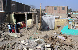
Earthquakes in 2007 resulted in many fatalities. The 2007 Peru earthquake was the deadliest with 595 fatalities. The September 2007 Sumatra earthquake was the largest in 2007 with an 8.4 on the moment magnitude scale. The 2007 Solomon Islands earthquake caused a significant tsunami that killed 52 people. There were four 8.0+ earthquakes in 2007 which is the most ever recorded for a single year. Other significant earthquakes in 2007 struck Chile and Japan.

Contents

Compared to other years

Number of Earthquakes Worldwide for 19992009
[ Worldwide ]
Magnitude Ranging Between 1999 2000 2001 2002 2003 2004 2005 2006 2007 2008 2009 2010 2011 2012 2013 2014 2015
8−9.9 0 1 1 0 1 2 1 2 4 1 1 1 1 2 2 1 1
7−7.9 18 14 15 13 14 14 10 9 13 12 16 21 19 15 17 11 18
6−6.9 118 145 121 126 140 141 140 142 178 168 144 151 204 129 125 144 124
5−5.9 1057 1335 1215 1171 1203 1515 1693 1712 2074 1768 1896 1963 2271 1412 1402 1577 1413
Total 1193 1495 1352 1310 1358 1672 1844 1865 2270 1948 2057 2136 2495 1558 1546 1733 1556

Note that an increase in detected earthquake numbers does not necessarily represent an increase in earthquakes per se. Population increase, habitation spread, and advances in earthquake detection technology all contribute to higher earthquake numbers being recorded over time. USGS's Website has more information.

For exact dates and live earthquakes please visit USGS's Global Earthquake Search Page and Real-time Earthquake Map or EMSC's Real-time Seismicity.

Overall

By death toll

RankDeath tollMagnitudeLocation MMI Depth (km)Date
15958.0 Flag of Peru.svg Peru, Pisco IX (Violent) 39.0August 15
2686.4 Flag of Indonesia.svg Indonesia, Sumatra VIII (Severe) 10.0March 6
3528.1 Flag of the Solomon Islands.svg Solomon Islands VIII (Severe) 10.0April 2
4238.4 Flag of Indonesia.svg Indonesia, Sumatra VI (Strong) 10.0September 12
5125.2 Flag of Tajikistan.svg Tajikistan VI (Strong) 10.0July 21
6116.6 Flag of Japan.svg Japan, Niigata IX (Violent) 10.0July 16
7106.2 Flag of Chile.svg Chile, Aysén VII (Very strong) 25.0April 21

By magnitude

RankMagnitudeDeath tollLocation MMI Depth (km)Date
18.423 Flag of Indonesia.svg Indonesia, Bengkulu offshoreVI (Strong) 10.0September 12
28.152 Flag of the Solomon Islands.svg Solomon Islands offshoreVIII (Severe) 10.0April 1
28.10 Flag of Russia.svg Russia, Kuril Islands offshoreVI (Strong) 5.6January 13
48.0595 Flag of Peru.svg Peru, Ica offshoreIX (Violent) 39.0August 15
57.90 Flag of Indonesia.svg Indonesia, Mentawai Islands VII (Very strong) 35.0September 12
67.80Flag of New Zealand.svg New Zealand, Kermadec Islands VII (Very strong) 152.0December 9
77.72 Flag of Chile.svg Chile, Tarapacá VIII (Severe) 40.0November 14
87.50 Flag of Indonesia.svg Indonesia, Jakarta offshoreV (Moderate) 280.0August 8
87.50 Flag of Japan.svg Japan, Volcano Islands offshoreVI (Strong) 20.0September 28
87.54 Flag of Indonesia.svg Indonesia, offshore Molucca Sea IX (Violent) 20.0January 21
117.40 Flag of New Zealand.svg New Zealand, Auckland Islands offshoreV (Moderate) 15.0September 30
117.41 Flag of France.svg France, Martinique offshoreVII (Very strong) 10.0November 29
137.20 Flag of Vanuatu.svg Vanuatu, Santo offshoreVII (Very strong) 20.0August 1
137.20 Flag of the Solomon Islands.svg Solomon Islands, Santa Cruz Islands offshoreVI (Strong) 20.0September 2
137.20 Flag of the Northern Mariana Islands.svg Mariana Islands offshoreIII (Weak) 30.0October 31
137.20 Flag of the United States.svg United States, Andreanof Islands offshoreVII (Very strong) 34.0December 19
177.10 Flag of Vanuatu.svg Vanuatu, Tanna offshoreVI (Strong) 30.0March 25
187.00 Flag of Indonesia.svg Indonesia, Mentawai Islands offshoreVII (Very strong) 10.0September 13

By month

January

January
Strongest magnitude8.1 Mw Flag of Russia.svg Russia
Deadliest7.5 Mw Flag of Indonesia.svg Indonesia
4 deaths
Total fatalities4
Number by magnitude
8.0–8.91
7.0–7.91
6.0–6.911
  • Flag of India.svg A magnitude 6.1 earthquake struck the Nicobar Islands, India on January 8 at a depth of 11.0 km (6.8 mi). [1]
  • Flag of Tajikistan.svg A magnitude 6.0 earthquake struck Vorukh, Tajikistan on January 8 at a depth of 16.0 km (9.9 mi). About 130 houses were destroyed and a mining complex were damaged in Isfana. At least 57 buildings were damaged in Vorukh. [2]
  • Flag of Fiji.svg A magnitude 6.3 earthquake struck Fiji on January 8 at a depth of 406.8 km (252.8 mi). [3]
  • Flag of the People's Republic of China.svg A magnitude 4.5 earthquake struck Gansu, China on January 9 at a depth of 20.0 km (12.4 mi). Around 2,000 buildings were damaged in the epicenter area. [4]
  • Flag of the People's Republic of China.svg A magnitude 4.7 earthquake struck Jilin, China on January 11 at a depth of 23.1 km (14.4 mi). Several buildings collapsed in the epicentral area. [5]
  • Flag of Indonesia.svg A magnitude 6.0 earthquake struck Ambon, Indonesia on January 11 at a depth of 13.0 km (8.1 mi).
  • Flag of Russia.svg A magnitude 8.1 earthquake struck the Kuril Islands, Russia on January 13 at a depth of 5.7 km (3.5 mi). This was a doublet of the 2006 Kuril Islands earthquake.
  • Flag of Indonesia.svg A magnitude 6.0 earthquake struck Papua, Indonesia on January 17 at a depth of 100.8 km (62.6 mi).
  • A Magnitude 6.2 earthquake struck the Carlsberg Ridge on January 17 at a depth of 8.0 km (5.0 mi).
  • Flag of South Georgia and the South Sandwich Islands.svg A magnitude 6.2 earthquake the South Sandwich Islands On January 20 at a depth of 10.0 km (6.2 mi).
  • Flag of Indonesia.svg A magnitude 7.5 earthquake struck Ternate, Indonesia on January 21 at a depth of 20.0 km (12.4 mi). Four people were killed and minor damage was caused in Manado.
  • Flag of Turkey.svg A magnitude 5.2 earthquake struck Ağrı, Turkey on January 21 at a depth of 3.1 km (1.9 mi). Two people were injured and some damage to old buildings was reported in Ağrı. [6]
  • Flag of the Republic of China.svg A magnitude 6.0 earthquake struck Hengchun, Taiwan on January 25 at a depth of 36.2 km (22.5 mi).
  • Flag of Australia (converted).svg A magnitude 6.9 earthquake struck Macquarie Island on January 30 at a depth of 11.0 km (6.8 mi).
  • Flag of the Northern Mariana Islands.svg A magnitude 6.6 earthquake struck The Northern Mariana Islands on January 30 at a depth of 20.0 km (12.4 mi).
  • Flag of New Zealand.svg A magnitude 6.5 earthquake struck The Kermadec Islands on January 31 at a depth of 34.0 km (21.1 mi).

February

February
Strongest magnitude6.7 Mw Flag of Indonesia.svg Indonesia
Number by magnitude
8.0–8.90
7.0–7.90
6.0–6.95
  • Flag of Jamaica.svg A magnitude 6.2 earthquake struck Lucea, Jamaica on February 4 at a depth of 10.0 km (6.2 mi).
  • Flag of Portugal (official).svg A magnitude 6.2 earthquake struck the Iberian Peninsula, Portugal on February 12 at a depth of 20.0 km (12.4 mi).
  • Flag of the Philippines.svg A magnitude 4.9 earthquake struck Davao, Philippines on February 16 at a depth of 78.9 km (49.0 mi). Minor damage was caused to an apartment in Davao City. [7]
  • Flag of Japan.svg A magnitude 6.0 earthquake struck Hokkaido, Japan on February 17 at a depth of 31.0 km (19.3 mi).
  • Flag of Indonesia.svg A magnitude 6.7 earthquake struck Sofifi, Indonesia on February 20 at a depth of 12.0 km (7.5 mi).
  • Flag of Turkey.svg A magnitude 5.7 earthquake struck Elazığ, Turkey on February 22 at a depth of 6.0 km (3.7 mi). Some buildings were damaged in Elazığ, and Pütürge. [8]
  • Flag of Peru.svg A magnitude 6.3 earthquake struck Pimentel, Peru on February 24 at a depth of 23.0 km (14.3 mi).

March

March
Strongest magnitude7.2 Mw Flag of Vanuatu.svg Vanuatu
Deadliest6.4 Mw Flag of Indonesia.svg Indonesia
68 deaths
Total fatalities69
Number by magnitude
8.0–8.90
7.0–7.91
6.0–6.99
  • Flag of Indonesia.svg Two events with magnitudes 6.4 and 6.2 struck Sumatra, Indonesia on March 6 at a depth of 11.0 km (6.8 mi), 68 people were killed and 460 People were Injured.
  • Flag of Colombia.svg A magnitude 5.2 earthquake struck Caqueta, Colombia on March 6 at a depth of 43.1 km (26.8 mi). Nine people were injured, eight buildings were destroyed and 63 damaged in Caqueta. [9]
  • Flag of Japan.svg A magnitude 6.1 earthquake struck the Izu Islands, Japan on March 8 at a depth of 139.6 km (86.7 mi).
  • Flag of South Georgia and the South Sandwich Islands.svg A magnitude 6.2 earthquake struck the South Sandwich Islands on March 8 at a depth of 10.0 km (6.2 mi).
  • Flag of Russia.svg A magnitude 6.0 earthquake struck Sergeyevka, Primorsky Krai, Russia [10] on March 9 at a depth of 441.2 km (274.1 mi).
  • Flag of Mexico.svg A magnitude 6.0 earthquake struck The Gulf of California on March 13 at a depth of 26.1 km (16.2 mi).
  • Flag of Colombia.svg A magnitude 6.2 earthquake struck Buenaventura, Colombia on March 18 at a depth of 7.0 km (4.3 mi).
  • Flag of Vanuatu.svg A magnitude 7.2 earthquake struck Isangel, Vanuatu on March 25 at a depth of 34.0 km (21.1 mi). A tsunami up to 16 cm Was Observed.
  • Flag of Japan.svg A magnitude 6.9 earthquake struck Noto, Japan on March 25 at a depth of 8.0 km (5.0 mi). One person was killed, 359 people were injured, and 13,556 buildings damaged or destroyed, as well as a tsunami up to 22 cm high.
  • Flag of Vanuatu.svg A magnitude 6.9 earthquake struck Vanuatu on March 25 at a depth of 35.0 km (21.7 mi).
  • Flag of Greece.svg A magnitude 5.7 earthquake struck Ionian Islands, Greece on March 6 at a depth of 15.0 km (9.3 mi). Some buildings were damaged and rockslides occurred in Argostolion. [11]

April

April
Strongest magnitude8.1 Mw Flag of the Solomon Islands.svg Solomon Islands
Deadliest8.1 Mw Flag of the Solomon Islands.svg Solomon Islands
52 deaths
Total fatalities62
Number by magnitude
8.0–8.91
7.0–7.90
6.0–6.913

May

May
Strongest magnitude6.5 Mw Flag of Fiji.svg Fiji
Number by magnitude
8.0–8.90
7.0–7.90
6.0–6.96
  • Flag of the People's Republic of China.svg A magnitude 6.1 earthquake struck Tibet, China on May 5 at a depth of 9.0 km (5.6 mi). Some buildings were damaged in Tibet.
  • Flag of Fiji.svg A magnitude 6.5 earthquake struck Levuka, Fiji on May 6 at a depth of 676.4 km (420.3 mi).
  • Flag of Chile.svg A magnitude 6.1 earthquake struck Aisen, Chile on May 7 at a depth of 10.0 km (6.2 mi).
  • Flag of Montana.svg A magnitude 4.4 earthquake struck Alder, Montana on May 8 at a depth of 13.5 km (8.4 mi). Some buildings were slightly damaged in Sheridan. [13]
  • Flag of Laos.svg A magnitude 6.3 earthquake struck Huay Xai, Laos on May 16 at a depth of 9.0 km (5.6 mi). Several buildings were damaged as far away as Thailand.
  • Flag of New Zealand.svg A magnitude 6.0 earthquake struck The Kermadec Islands, New Zealand on May 17 at a depth of 40.7 km (25.3 mi).
  • Flag of Russia.svg A magnitude 6.4 earthquake struck Kamchatka, Russia on May 30 at a depth of 116.0 km (72.1 mi).

June

June
Strongest magnitude6.7 Mw Flag of Guatemala.svg Guatemala
Deadliest6.1 Mw Flag of the People's Republic of China.svg China
3 deaths
Total fatalities3
Number by magnitude
8.0–8.90
7.0–7.90
6.0–6.95
  • Flag of the People's Republic of China.svg A magnitude 6.1 earthquake struck Jinghong, China on June 2 at a depth of 5.0 km (3.1 mi), 3 people were killed and 329 were injured.
  • Flag of Papua New Guinea.svg A magnitude 6.2 earthquake struck Lorengau, Papua New Guinea on June 7 at a depth of 4.7 km (2.9 mi).
  • Flag of Guatemala.svg A magnitude 6.7 earthquake struck Iztapa, Guatemala on June 13 at a depth of 16.0 km (9.9 mi). Some buildings were damaged in Guatemala City.
  • Flag of Iran.svg A magnitude 5.5 earthquake struck Qom, Iran on June 18 at a depth of 5.0 km (3.1 mi). Some buildings were damaged slightly in Qom. [14]
  • A magnitude 6.5 earthquake struck the Mid-Atlantic Ridge on June 24 at a depth of 10.0 km (6.2 mi).
  • Flag of Papua New Guinea.svg A magnitude 6.6 earthquake struck Panguna, Papua New Guinea on June 28 at a depth of 18.0 km (11.2 mi).

July

July
Strongest magnitude6.9 Mw Flag of Indonesia.svg Indonesia
Deadliest5.2 Mw Flag of Tajikistan.svg Tajikistan
12 deaths
Total fatalities23
Number by magnitude
8.0–8.90
7.0–7.90
6.0–6.97
Damaged pavement tiles in Higashi-honcho, Kashiwazaki, Japan by the earthquake. Sidewalk of Higashi-honcho, Kashiwazaki City 001.jpg
Damaged pavement tiles in Higashi-honcho, Kashiwazaki, Japan by the earthquake.
  • Flag of Peru.svg A magnitude 6.1 earthquake struck Pucallpa, Peru on July 13 at a depth of 152.1 km (94.5 mi).
  • Flag of Ecuador (1900-2009).svg A magnitude 4.5 earthquake struck Loja, Ecuador on July 12 at a depth of 49.9 km (31.0 mi). Some damage to houses was caused in Zaruma. [15]
  • Flag of the United States.svg A magnitude 6.1 earthquake struck Nikolski, Alaska on July 15 at a depth of 15.0 km (9.3 mi).
  • Flag of Japan.svg A magnitude 6.6 earthquake struck Chūetsu, Japan on July 16 at a depth of 10.0 km (6.2 mi). Eleven people were killed, more than 1,000 were injured and a minor tsunami was triggered.
  • Flag of Japan.svg A magnitude 6.8 earthquake struck Mikuni, Japan on July 15 at a depth of 350.4 km (217.7 mi).
  • Flag of the People's Republic of China.svg A magnitude 5.6 earthquake struck Xinjiang, China on July 20 at a depth of 10.0 km (6.2 mi). At least 2,120 houses and four bridges were damaged or destroyed. [16]
  • Flag of Brazil.svg A magnitude 6.1 earthquake struck Tarauacá, Brazil on July 21 at a depth of 644.9 km (400.7 mi).
  • Flag of Tajikistan.svg A magnitude 5.2 earthquake struck Rasht, Tajikistan on July 21 at a depth of 10.0 km (6.2 mi). 12 people were killed, three by falling debris, nine by a landslide.
  • Flag of Argentina.svg Flag of Bolivia.svg A magnitude 6.4 Earthquake struck near the Argentina-Bolivia border on July 21 at a depth of 289.5 km (179.9 mi).
  • Flag of India.svg A magnitude 5.1 earthquake struck Uttarkhand, India on July 22 at a depth of 19 km (12 mi). Three people were injured and several buildings were damaged. Rockslides also occurred. [17]
  • Flag of Indonesia.svg A magnitude 6.9 earthquake struck Tobelo, Indonesia on July 26 at a depth of 25.0 km (15.5 mi). Around 5 people were injured.

August

August
Strongest magnitude8.0 Mw Flag of Peru.svg Peru
Deadliest8.0 Mw Flag of Peru.svg Peru
595 deaths
Total fatalities621
Number by magnitude
8.0–8.91
7.0–7.92
6.0–6.94
A pile of rubble after the earthquake in Peru. 40 - Tremblement de terre - Aout 2007.JPG
A pile of rubble after the earthquake in Peru.
  • Flag of Vanuatu.svg A magnitude 7.2 earthquake struck Luganville, Vanuatu on August 1 at a depth of 120.0 km (74.6 mi). Some roads, buildings and a bridge were damaged in Luganville. A policeman suffered injuries while evacuating. [18]
  • Flag of Russia.svg A magnitude 6.2 earthquake struck Kholmsk, Russia on August 2 at a depth of 5.0 km (3.1 mi). Two people were killed, twelve people were injured and a 1 ft (0.30 m) tsunami was observed in Hokkaido, Japan. A magnitude 4.9 aftershock injured two more people. [19]
  • Flag of Alaska.svg A magnitude 6.7 earthquake struck Adak, Alaska on August 2 at a depth of 21.0 km (13.0 mi).
  • Flag of Indonesia.svg A magnitude 7.5 earthquake struck Java, Indonesia on August 8 at a depth of 280.0 km (174.0 mi). Some damage was caused in Sukabumi, such as cracks on walls. In the same regency, the walls of two schools collapsed. [20]
  • Flag of Peru.svg A devastating magnitude 8.0 earthquake struck Pisco, Peru on August 15 at a depth of 39.0 km (24.2 mi), 595 people were killed, 2,291 people were injured, and a 5 metre high tsunami was observed. [21]
  • Flag of the Philippines.svg A magnitude 6.4 earthquake struck Mindanao, Philippines, on August 20 at a depth of 8.0 km (5.0 mi).
  • Flag of India.svg A magnitude 4.4 earthquake struck Maharashtra, India on August 21 at a depth of 5.0 km (3.1 mi). Slight damage was observed in Satara. [22]
  • Flag of Iran.svg A magnitude 5.0 earthquake struck Hormozgan, Iran on August 25 at a depth of 10.0 km (6.2 mi). Four people were injured in Bandar Abbas. [23]
  • Flag of Tonga.svg A magnitude 6.1 earthquake struck Neiafu, Tonga, on August 26 at a depth of 127.4 km (79.2 mi).

September

September
Strongest magnitude8.4 Mw Flag of Indonesia.svg Indonesia
Deadliest8.4 Mw, Flag of Indonesia.svg Indonesia
25 deaths
Total fatalities25
Number by magnitude
8.0–8.91
7.0–7.95
6.0–6.94
  • Flag of the Solomon Islands.svg A magnitude 7.2 earthquake struck Lata, Solomon Islands on September 2 at a depth of 35.0 km (21.7 mi). [24]
  • Flag of the Republic of China.svg A magnitude 6.2 earthquake struck Yilan, Taiwan on September 6 at a depth of 53.0 km (32.9 mi). At least one building was damaged in Lotung. [25]
  • Flag of Colombia.svg A magnitude 6.8 earthquake struck Timbiquí, Colombia on September 10 at a depth of 15.0 km (9.3 mi). Five people were injured.
  • Flag of Indonesia.svg A magnitude 8.4 earthquake struck Sumatra, Indonesia on September 12 at a depth of 34 km (21 mi). 25 people were killed, 161 people were injured and a 7.5 foot (2.27 metres) tsunami was generated. [26]
  • Flag of Indonesia.svg A magnitude 7.9 earthquake struck Sumatra, Indonesia on September 13 at a depth of 35.0 km (21.7 mi). This was an aftershock of the 8.4 earthquake the day before.
  • Flag of Indonesia.svg A magnitude 7.0 earthquake struck Padang, Indonesia on September 13 at a depth of 22.0 km (13.7 mi). This was an aftershock of the 8.4 earthquake the day before.
  • Flag of Honduras (2022-present).svg A magnitude 5.3 earthquake struck Yoro Department, Honduras on September 15 at a depth of 32.8 km (20.4 mi). Eighteen people injured, 175 structures destroyed and 401 others damaged in the Marale-Yorito area. [27] [28]
  • Flag of Indonesia.svg A magnitude 6.7 earthquake struck Padang, Indonesia on September 20 at a depth of 30.0 km (18.6 mi). This Was an Aftershock of the 8.4 earthquake 8 days prior.
  • Flag of Papua New Guinea.svg A magnitude 6.8 earthquake struck Kokopo, Papua New Guinea on September 26 at a depth of 40.0 km (24.9 mi).
  • Flag of Japan.svg A magnitude 7.5 earthquake struck the Volcano Islands on September 28 at a depth of 120.0 km (74.6 mi).
  • Flag of the Northern Mariana Islands.svg A magnitude 6.9 earthquake struck the Northern Mariana Islands on September 30 at a depth of 14.0 km (8.7 mi).
  • Flag of New Zealand.svg A magnitude 7.4 earthquake struck the Auckland Islands on September 30 at a depth of 10.0 km (6.2 mi).

October

October
Strongest magnitude7.2 Mw Flag of the Northern Mariana Islands.svg Northern Mariana Islands
Number by magnitude
8.0–8.90
7.0–7.91
6.0–6.93
  • Flag of Fiji.svg A magnitude 6.5 earthquake struck Fiji on October 5 at a depth of 509.4 km (316.5 mi).
  • Flag of New Zealand.svg A magnitude 6.8 earthquake struck Te Anau, New Zealand on October 15 at a depth of 18.0 km (11.2 mi).
  • Flag of Fiji.svg A magnitude 6.6 earthquake struck Fiji on October 16 at a depth of 509.3 km (316.5 mi).
  • Flag of California.svg A magnitude 5.6 earthquake struck Alum Rock, California on October 30 at a depth of 9.7 km (6.0 mi). Minor damage occurred at San Jose. [29]
  • Flag of the Northern Mariana Islands.svg A magnitude 7.2 earthquake struck The Northern Mariana Islands on October 31 at a depth of 207.0 km (128.6 mi).

November

November
Strongest magnitude7.7 Mw Flag of Chile.svg Chile
Deadliest7.4 Mw Flag-of-Martinique.svg Martinique
6 deaths
Total fatalities14
Number by magnitude
8.0–8.90
7.0–7.92
6.0–6.94
  • Flag of India.svg A magnitude 5.1 earthquake struck Gujarat, India on November 6 at a depth of 10.0 km (6.2 mi). One person died, five were injured and several buildings were damaged or collapsed in Talala. [30]
  • Flag of the Philippines.svg A magnitude 5.3 earthquake struck Bohol, Philippines on November 7 at a depth of 71.6 km (44.5 mi). One person died in Mabini. [31]
  • Flag of Bangladesh.svg A magnitude 5.5 earthquake struck Chittagong, Bangladesh on November 7 at a depth of 28.7 km (17.8 mi). Ten people were injured and minor damage was caused. [32] One person was also killed in neighboring Myanmar. [33]
  • Flag of Chile.svg A magnitude 7.7 earthquake struck Tocopilla, Chile on November 14 at a depth of 40.0 km (24.9 mi). Two people were killed and 20 people were injured. A tsunami up to 25.5 cm was also triggered. [34]
  • Flag of Chile.svg A magnitude 6.9 earthquake struck Tocopilla, Chile on November 15 at a depth of 26.0 km (16.2 mi).
  • Flag of Ecuador (1900-2009).svg A magnitude 6.8 earthquake struck Macas, Ecuador on November 16 at a depth of 122.9 km (76.4 mi). Slight damage was caused in Guayaquil.
  • Flag of Iran.svg . A magnitude 4.8 earthquake struck Khuzestan, Iran on November 20 at a depth of 7.0 km (4.3 mi). Thirty people were injured and slight damage was caused. [35]
  • Flag of Papua New Guinea.svg A magnitude 6.8 earthquake struck Lae, Papua New Guinea on November 22 at a depth of 53.0 km (32.9 mi). A water tower was damaged and power was knocked out in Lae.
  • Flag of Indonesia.svg A magnitude 6.5 earthquake struck Dompu, Indonesia on November 25 at a depth of 20.0 km (12.4 mi), 3 people were killed and hundreds were injured.
  • Flag of the Philippines.svg A magnitude 5.9 earthquake struck Luzon, Philippines on November 27 at a depth of 35.0 km (21.7 mi). Electricity and communications were disrupted at Baguio. [36]
  • Flag of France (lighter variant).svg A magnitude 7.4 earthquake struck Martinique in November 29 at a depth of 156 km (97 mi). 6 people were killed and over 100 were injured.

December

December
Strongest magnitude7.8 Mw Flag of New Zealand.svg New Zealand
Deadliest6.6 Mw Flag of New Zealand.svg New Zealand
1 death
4.9 Mw Flag of Brazil.svg Brazil
1 death
Total fatalities2
Number by magnitude
8.0–8.90
7.0–7.92
6.0–6.92
Damage in New Zealand from the earthquake. 2007 Gisborne Earthquake Health2000.jpg
Damage in New Zealand from the earthquake.
  • Flag of Brazil.svg A magnitude 4.9 earthquake struck Minas Gerais, on December 9 at a depth of 10.0 km (6.2 mi). One person died and 6 others were injured.
  • Flag of New Zealand.svg A magnitude 7.8 earthquake struck the Kermadec Islands, south of the Fiji Islands on December 9 at a depth of 152.5 km (94.8 mi).
  • Flag of Samoa.svg A magnitude 6.2 earthquake struck Samoa on December 13 at a depth of 17.0 km (10.6 mi).
  • Flag of Chile.svg A magnitude 5.9 earthquake struck Valparaiso, Chile on December 15 at a depth of 25.0 km (15.5 mi). Four people were injured at Viña del Mar and several buildings damaged in Valparaíso. [37]
  • Flag of Chile.svg A magnitude 6.7 earthquake struck Antofagasta, Chile on December 16 at a depth of 45.0 km (28.0 mi). Power and communications were disrupted throughout the epicentral area from Antofagasta to Iquique. [38]
  • Flag of Alaska.svg A magnitude 7.2 earthquake struck Adak, Alaska on December 19 at a depth of 34.0 km (21.1 mi).
  • Flag of New Zealand.svg A magnitude 6.6 earthquake struck Gisborne, New Zealand on December 20 at a depth of 20.0 km (12.4 mi). One person died of a heart attack and 11 others were injured. [39]
  • Flag of Turkey.svg A magnitude 5.7 earthquake struck Ankara, Turkey on December 20 at a depth of 10.0 km (6.2 mi). A minaret and other buildings collapsed at Yeniyapan and a mosque and animal shelters were damaged at Abazlar. Mud brick houses and masonry structures were damaged at Sırapınar. Shelters collapsed at Suyugüzel and killed about 100 animals. Slight damage occurred in Ankara. [40]
  • Flag of Turkey.svg A magnitude 5.6 earthquake struck Ankara, Turkey on December 26 at a depth of 8.3 km (5.2 mi). 2,214 buildings were damaged in Ankara. [41]

See also

References

  1. "M 6.1 – Andaman Islands, India region". United States Geological Survey. Retrieved 5 January 2022.
  2. "M 6.0 – 23 km WSW of Vorukh, Tajikistan". United States Geological Survey. Retrieved 5 January 2022.
  3. "M 6.3 – Fiji region". United States Geological Survey. Retrieved 5 January 2022.
  4. "M 4.5 – 57 km NNW of Baiyin, China". United States Geological Survey. Retrieved 3 March 2022.
  5. "M 4.7 – 130 km S of Mawu, China". United States Geological Survey.
  6. "M 5.2 – 10 km W of Hamur, Turkey". United States Geological Survey. Retrieved 3 March 2022.
  7. "M 4.9 – 15 km E of Tibanbang, Philippines". United States Geological Survey.
  8. "M 5.7 – 12 km N of Çüngü?, Turkey". United States Geological Survey.
  9. "M 5.2 – 23 km SE of Paispamba, Colombia". United States Geological Survey.
  10. "6.2 quake near Primorye, Russia". Broadband Seismic Data Collection Center (ANZA): eqinfo. Institute of Geophysics and Planetary Physics, Scripps Institution of Oceanography, University of California, San Diego.
  11. "M 5.7 – 15 km N of Lixoúri, Greece". United States Geological Survey.
  12. "M 5.1 – 11 km ENE of Ueno-ebisumachi, Japan". United States Geological Survey.
  13. "M 4.4 – 8 km NNW of Alder, Montana". United States Geological Survey.
  14. "M 5.5 – 22 km S of Qom, Iran". United States Geological Survey.
  15. "M 4.5 – 18 km NE of Celica, Ecuador". United States Geological Survey.
  16. "M 5.6 – 90 km SW of Xinyuan, China". United States Geological Survey.
  17. "M 5.1 – Uttaranchal, India". United States Geological Survey.
  18. "Powerful earthquake damages Luganville on Vanuatu island of Santo". Radio New Zealand. 2007-08-02. Retrieved 2022-03-03.
  19. "M 4.9 – 6 km WSW of Nevel'sk, Russia". United States Geological Survey.
  20. "14 Tahun Lalu, Gempa Merusak M7,5 Guncang Bandung, Jakarta, Semarang dan Yogyakarta". Sindonews (in Indonesian). 2021-08-09. Retrieved 2022-03-08.
  21. "Hoy, hace seis años, Pisco fue sacudido por un terremoto de 7.9 grados" (in Spanish). 15 August 2013. Archived from the original on 2 January 2017.
  22. "M 4.4 – 22 km ESE of M?khjan, India". United States Geological Survey.
  23. "M 5.0 – 113 km NNE of Bandar Abbas, Iran". United States Geological Survey.
  24. "M 7.2 – 97 km S of Lata, Solomon Islands". United States Geological Survey.
  25. "M 6.2 – 66 km SE of Yilan, Taiwan". United States Geological Survey.
  26. Lorito, Stefano; Romano, Fabrizio; Piatanesi, Alessio; Boschi, Enzo (2008). "Source process of the September 12, 2007, MW 8.4 southern Sumatra earthquake from tsunami tide gauge record inversion". Geophysical Research Letters. 35 (2). Bibcode:2008GeoRL..35.2310L. doi: 10.1029/2007GL032661 .
  27. "M 5.3 - 6 km SSE of Marale, Honduras". United States Geological Survey.
  28. "Unas 19 replicas han sacudido Honduras tras sismo del sábado". Proceso. September 16, 2007.
  29. "M 5.5 – 6 km NNE of East Foothills, California". United States Geological Survey.
  30. "M 5.1 – 17 km S of V?s?vadar, India". United States Geological Survey.
  31. "M 5.3 – 8 km ESE of Bacong, Philippines". United States Geological Survey.
  32. "M 5.5 – 18 km ESE of Bandarban, Bangladesh". United States Geological Survey.
  33. "ASC :: 7 November 2007, M5.1 Roninpara Earthquake (Chittagong Hill Tracts), Bangladesh". asc-india.org.
  34. "M 7.7 – 36 km ESE of Tocopilla, Chile". United States Geological Survey.
  35. "M 4.8 – 54 km NE of Ramhormoz, Iran". United States Geological Survey.
  36. "M 5.9 – 5 km S of Bangan-Oda, Philippines". United States Geological Survey.
  37. "M 5.9 – 38 km N of Valparaíso, Chile". United States Geological Survey.
  38. "M 6.7 – 80 km NNE of Antofagasta, Chile". United States Geological Survey.
  39. "M 6.6 – 46 km SSE of Gisborne, New Zealand". United States Geological Survey.
  40. "M 5.7 – 24 km SW of Karakeçili, Turkey". United States Geological Survey.
  41. "M 5.6 – 24 km SW of Karakeçili, Turkey". United States Geological Survey.