Zaruma

Last updated
Zaruma
Town
Villa Real De San Antonio del Cerro de Oro de Zaruma
Bandera zaruma 2.jpg
Escudo Zaruma.jpg
Nickname: 
Sultana de El Oro
Ecuador location map.svg
Red pog.svg
Zaruma
Location of Zaruma within Ecuador
Coordinates: 03°41′00″S79°36′00″W / 3.68333°S 79.60000°W / -3.68333; -79.60000
Country Ecuador
Province El Oro Province
Canton Zaruma Canton
FoundationDecember 8, 1595
Founded by Damian Meneses
Named for zara and huma
Government
  TypeMayor and council
   Mayor Carlos Aguilar
Area
  Town2.6 km2 (1.0 sq mi)
Elevation
1,200 m (3,900 ft)
Population
 (2022 census) [1]
  Town10,005
  Density3,800/km2 (10,000/sq mi)
Demonym Zarumeño(-a)
Time zone UTC-5 (ECT)
Postal code
EC071150 (new format)
Area code(s) (0)72972, (0)72973
Website http://www.zaruma.gob.ec

Zaruma, officially Villa Real de San Antonio del Cerro de Oro de Zaruma is a town in the south of Ecuador, El Oro Province. It is located in the south-east of this province, at an altitude of 1200 metres above sea level, on an inter-Andes route where the Vizcaya mountain range branches off from the Chilla mountain range. It is the seat of Zaruma Canton, one of the oldest cantons in the province.

Contents

Zaruma is known for its republic-era architecture, gold mines, culture and traditions, art and coffee and for having been founded by Spanish explorer Alonso de Mercadillo. These attributes have led to its receiving various titles celebrating both its tangible and intangible aspects, and in 1998 the Ecuadorian Institute for Cultural Heritage submitted it as a candidate UNESCO World Heritage Site.

Zaruma was named a Pueblo Mágico (magical town) by the Ecuadorian Ministry of Tourism (MINTUR) in 2019. It is one of five communities across the country that inaugurated the programme that year. [2]

View of Zaruma Vista de Zaruma.jpg
View of Zaruma

Etymology

The word Zaruma is formed from two quichua words: sara, which means corn, and uma, which means head. That is to say, Zaruma to translates to "corn head", a name attributed to the existing corn and to the gold mined here, which is similar in colour to a corncob. It is not known why the spelling was altered from "Saruma" to "Zaruma". However, historian Jorge Núñez claims that Zaruma means "small mountain peak".

History

First settlers

Petroglyphs Petroglifos Zaruma.jpg
Petroglyphs

It is believed that one of the few states existing among early settlers was Zarzas, which contained eleven tribes: the Cariamangas, Catacochas, Catamayus, Gonzanamaes, Guachanamaes, Malacatos, Piscobambas, Vilcabambas, Yanganas and Zarumas. [3]

Integration

It is believed that the Cañari settled in what is now Zaruma canton between 500 and 1400 CE. This is supported by the existence of important archeological sites such as Guayquichuma, Chepel, Payama, Trencilla, San Antonio, Chiva Turco, Tocto Shuqin, Guartiguro, among others, all of which have been attributed to the Cañari.

Inca invasion

In the 1480s, the Cañari settled in Zaruma were overpowered by the Incas who were then under the command of Huayna Capac. After ordering his subordinates to explore the north, they invaded the Zaruma basin, enslaving the indigenous Cañari for 50 years.

The Inca, now settled in Zaruma, felt compelled to contribute to the ransom of Atahualpa when he was taken prisoner by the Spanish. In 1533, their chief Quinará decided to take a lot of gold in order to pay this ransom. Records say that he crossed the river Pisco Bamba, Catamayo Canton, but on learning of Atahualpa's execution he buried the gold in deep galleries close to the Guatuchi Hacienda in Loja Province.

Conquest and foundation

In 1549, the first Spanish towns were established in this region by the Spanish caudillo Alonso de Mercadillo. Zaruma became very important because of its rich gold deposits, for which reason Philip II of Spain granted it the title of "Villa de Sant Antonio del Zerro de Oro de Zaruma" (Villa Real de San Antonio del Cerro de Oro de Zaruma on October 17, 1593.

On 8 December 1595, Captain Damián Meneses (under the orders of García Hurtado de Mendoza, Viceroy of Peru) fulfilled the royal edict and definitively founded Zaruma. This foundation had much significance for the area, including the loss of its cultural identity due to the imposition of a dominant culture, as well as the formation of rigid structures of injustice against indigenous rights.

On 20 January 1749, the city and the majority of its mines were destroyed by an earthquake. To the misfortune of the Spanish, a large indigenous rebellion erupted and resulted in a mass exodus and the ruin of the city. After this, Zaruma entered into a deep economic depression, but with the efforts of some miners and official aid from the Crown allowed the importation of native peoples to work in the mines, which allowed the improvement of the city's circumstances. Research suggests that between 1536 and 1820, Spain benefited from approximately 2,700 tonnes of Zaruman gold.

Independence

On 26 November 1820, Zaruma declared its independence from Spain. Following the examples of Quito, Guayaquil and Cuenca, a group of Zaruman patriots supported by Cuencan intellectuals declared their independence despite the fierce opposition of the government of Loja. The architects of its freedom were Fray Justo Gaona and Francisco Barnuevo, together with Ambrosio Maldonado, Bonifacio de los Reyes, Antonio Barzallo, José María Gálvez and José Gusmán y Román, citizens who signed a document at the Loja council house, now considered as its independence act.

After independence, the area fell into a state of deep depression. However, its mining industry never completely disappeared.

Gran Colombia and Zaruma's Gold

On 25 June 1824, Zaruma was raised to the level of canton according to the Colombian territorial division law, which named it as part of the province of Loja, department of Azuay. The Liberator Simón Bolivar, trying to reenergise mining production and find resources for administering the state, passed the Mining Laws in 1829 and named Sr Manuel Astudillo Samaniego as the Mining Magistrate for this canton.

Restarting the economy

The newly formed state invited technicians and businesses from throughout the world to invest in mining, especially in Zaruma. In 1862, García Moreno created a tax on mining in order to benefit Zaruma municipality. In 1876, Ignacio de Veintimilla hired the German geologist Teodoro Wolf to study Zaruma's mines. Later, in 1860, the Great Zaruma Gold Mining Company Limited was formed with the help of English investments and a total capital of £250,000.

El Oro Province

On 29 November 1882, Zaruma, Machala and Santa Rosa provinces declared the creation of a new province named El Oro, in honour of the region's gold, of which Zaruma was capital until 1884. On 23 April 1884, with the New Law of Territorial Division, the province was recognised but with its capital in Machala.

Crypto-Judaism

It has been widely reported for many years that Zaruma and its neighboring city Loja, Ecuador has been a safe-haven place for Crypto-Jews. Evidence includes customs and a Ladino dialect. [4] [5]

In December 2013, Israeli Ambassador Eliyahu Yerushalmi officially visited the governor of El Oro, hosting several councillors in the presence of the mayor Danilo Astudillo Mora, the main local authorities, representatives of institutions, schools and student delegations symbolically handing over the keys of the city. The mayor also announced that this would establish some points of cooperation that would affect the development of the region. Jose Reyes Aguilar, head of the University of Quevedo, also presented some views on the reality of the livestock sector and the future agreements established with Israel. The Israeli Ambassador took the floor to congratulate the authorities and its people for preserving a wonderful, pleasant and unique city, which identifies its Sephardic descent, and offered to build international relations in the areas of technology and education. [6]

Other dates

In 1990, the Ecuadorian Ministry for Education and Culture declared Zaruma as an Ecuatorian Cultural Heritage site. Since 1998, Zaruma has been on Unesco's list of candidates for World Heritage Site. In 2022, arachnologists named a large new species of tarantula from Zaruma after the town: Pamphobeteus zaruma Sherwood et al., 2022 [7]

Related Research Articles

<span class="mw-page-title-main">Machala</span> City in El Oro, Ecuador

Machala is a city in south-west Ecuador. It is the capital of the El Oro Province, and is located near the Gulf of Guayaquil on fertile lowlands. Machala has a population of 288,072 ; it is the sixth-biggest city in the country, and the second-most important port. It has been referred to as the Banana Capital of the World.
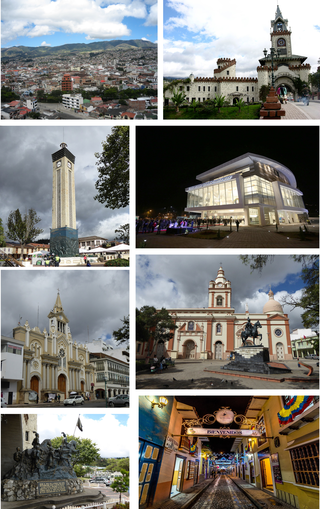
<span class="mw-page-title-main">Cuenca, Ecuador</span> City in Azuay, Ecuador

Santa Ana de los Cuatro Ríos de Cuenca, commonly referred to as Cuenca, is the capital and largest city of the Azuay Province of Ecuador. Cuenca is located in the highlands of Ecuador at about 2,560 metres above sea level, with an urban population of 361,524 and a population of 596,101 in the Cuenca Canton.

Ecuador is a multicultural and multiethnic nation, with the majority of its population is descended from a mixture of both European and Amerindian ancestry. The other 10% of Ecuador's population originate east of the Atlantic Ocean, predominantly from Spain, Italy, Lebanon, France and Germany. Around the Esmeraldas and Chota regions, the African influence would be strong among the small population of Afro-Ecuadorians that account for no more than 10%. Close to 80% of Ecuadorians are Roman Catholic, although the indigenous population blend Christian beliefs with ancient indigenous customs. The racial makeup of Ecuador is 70% mestizo, 7% Amerindian 7%, 12% White, and 11% Black.

<span class="mw-page-title-main">El Oro Province</span> Province of Ecuador

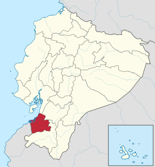
El Oro is the southernmost of Ecuador's coastal provinces. It was named for its historically important gold production. Today it is one of the world's major exporters of bananas. The capital is Machala.

<span class="mw-page-title-main">Loja Province</span> Province of Ecuador

Loja Province is one of 24 provinces in Ecuador and shares its southern border on the west with El Oro Province, on the north with El Azuay, and on the east with Zamora-Chinchipe. Founded on its present site in 1548 by Captain Alonso de Mercadillo (Spanish), the site had been previously moved and rebuilt from La Toma due to earthquakes. It also is named as "Cuxibamba Valley", from the Quichua language, which means the "Smiley Valley".

<span class="mw-page-title-main">Zamora-Chinchipe Province</span> Province of Ecuador

Zamora Chinchipe, Province of Zamora Chinchipe is a province of the Republic of Ecuador, located at the southeastern end of the Amazon Basin, which shares borders with the Ecuadorian provinces of Azuay and Morona Santiago to the north, Loja and Azuay to the west, and with Peru to the east and south. The province comprises an area of approximately 10,559 km² and is covered with a uniquely mountainous topography which markedly distinguishes it from the surrounding Amazonian provinces. Zamora-Chinchipe is characterized and largely identified by its mining industry; indigenous ethnic groups with a rich archaeological legacy; its biodiversity; and its niche and tourist attractions, which include a number of waterfalls well-noted for their beauty. The province takes its name from the bureaucratic fusion of the Zamora and Chinchipe cantons. The provincial capital is the city of Zamora.

<span class="mw-page-title-main">Loja, Ecuador</span> City in Loja, Ecuador

Loja, formerly Loxa and fully City of the Immaculate Conception of Loja, is the capital of Ecuador's Loja Province. It is located in the Cuxibamba valley in the south of the country, sharing borders with the provinces of Zamora-Chinchipe and other cantons of the province of Loja. Loja holds a rich tradition in the arts, and for this reason is known as the Music and Cultural Capital of Ecuador. The city is home to two major universities.

<span class="mw-page-title-main">Ecuadorian–Peruvian War</span> 1941 South American border conflict

The Ecuadorian–Peruvian War, known locally as the War of '41, was a South American border war fought between 5–31 July 1941. It was the first of three military conflicts between Ecuador and Peru during the 20th century.
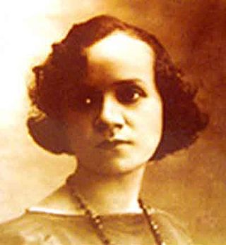
<span class="mw-page-title-main">Matilde Hidalgo</span> Ecuadorian physician and sufragist

Matilde Hidalgo de Procel was an Ecuadorian physician, poet, and activist. Matilde Hidalgo was the first woman to exercise the right to vote in Ecuador, and also the first to receive a Doctorate in Medicine. Hidalgo fought for the recognition of women's rights and is now known as one of the most important women in Ecuadorian history. At her young age, She mastered reading and writing skills as well as the piano. In 1973 she was paralyzed by a stroke, and she died in Guayaquil on February 20, 1974.

Piñas is a canton in the El Oro Province, Ecuador. Its seat is Piñas. It is also known as the "Orchid of The Andes" because of the many orchids grown nearby. The town was named Piñas by Juan de Loayza, in honor of his homeland Piñas in Spain. It is located 1,126 metres (3,694 ft) above sea level.

<span class="mw-page-title-main">Gualaceo Canton</span> Canton in Azuay, Ecuador

Gualaceo, nicknamed “El Jardin del Azuay”, is a canton in the sierra region of Ecuador in the Azuay Province. It is located 35 km east from the city of Cuenca and is one of the biggest cities in Azuay.

<span class="mw-page-title-main">Alamor</span> Place in Loja Province, Ecuador

Alamor is the head of the Puyango canton, province of Loja, Ecuador.

<span class="mw-page-title-main">El Guabo Canton</span> Canton in El Oro Province, Ecuador

The Guabo is a canton in the province of El Oro in Ecuador. Its capital is the city cantonal Guabo. Its population in the 2010 census was 50,009 inhabitants. The date of canton of El Guabo was September 7, 1978. The mayor for the period 2009-2014 was John Franco Aguilar.

<span class="mw-page-title-main">Machala Canton</span> Canton in El Oro Province, Ecuador

Machala Canton is a canton of Ecuador, located in the El Oro Province. Its capital is the town of Machala. Its population at the 2001 census was 217,696.

<span class="mw-page-title-main">Zaruma Canton</span> Canton in El Oro Province, Ecuador

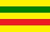
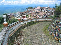
Zaruma Canton is a canton of Ecuador, located in the El Oro Province. Its capital is the town of Zaruma. Its population at the 2001 census was 23,407.

<span class="mw-page-title-main">Marcel Jacobo Laniado de Wind</span> Ecuadorian agricultural engineer and banker

Marcel Jacobo Laniado de Wind was an Ecuadorian agricultural engineer and banker who held a number of important public and private positions in Ecuador. He was a humanist, and a public figure in Ecuador for his efforts to improve the country.

<span class="mw-page-title-main">History of the Jews in Ecuador</span>

The history of the Jews in Ecuador dates back to the 16th and 17th centuries, when Sephardic Jews began arriving from Spain and Portugal as a result of the Spanish Inquisition. Ecuadorian Jews are members of a small Jewish community in the territory of today's Ecuador, and they form one of the smallest Jewish communities in South America.

<span class="mw-page-title-main">Octavio Cordero Palacios (writer)</span>

Octavio Cordero Palacios was an Ecuadorian writer, playwright, poet, mathematician, lawyer, professor and inventor.

<span class="mw-page-title-main">Battle of Zarumilla</span> Battle of the 1941 Ecuadorian–Peruvian War

The Battle of Zarumilla was a military confrontation between Peru and Ecuador that took place from July 23 to 31 during the 1941 Ecuadorian–Peruvian War.

References

  1. Citypopulation.de
  2. "Zaruma declarada Pueblo Mágico de Ecuador – Ministerio de Turismo" (in Spanish). Retrieved 2021-04-02.
  3. Mora, Luis F. Ecuador Austral.
  4. The Lost Sephardic Tribes of Latin America
  5. El Rostro de una Presencia
  6. Israel Ambassador visited Zaruma. Archived April 30, 2014, at the Wayback Machine
  7. Sherwood, D., Gabriel, R., Brescovit, A. D. & Lucas, S. M. (2022). On the species of Pamphobeteus Pocock, 1901 deposited in the Natural History Museum, London, with redescriptions of type material, the first record of P. grandis Bertani, Fukushima & Silva, 2008 from Peru, and the description of four new species. Arachnology 19(3): 650-674. Online at: https://www.researchgate.net/publication/364738566_On_the_species_of_Pamphobeteus_Pocock_1901_deposited_in_the_Natural_History_Museum_London_with_redescriptions_of_type_material_the_first_record_of_P_grandis_Bertani_Fukushima_Silva_2008_from_Peru_and_