2007 Solomon Islands earthquake

Last updated

2007 Solomon Islands earthquake
Oceania laea relief location map.jpg
Bullseye1.png
Relief map of Solomon Islands.png
Bullseye1.png
UTC  time2007-04-01 20:39:56
ISC  event 11912481
USGS-ANSS ComCat
Local date2 April 2007 (2007-04-02)
Local time7:39:56 a.m. (UTC+11)
Magnitude8.1 Mw , 7.8 Ms
Depth10 km (6.2 mi)
Epicenter 8°29′S156°58′E / 8.48°S 156.97°E / -8.48; 156.97
Areas affectedSolomon Islands
Papua New Guinea
Max. intensity VIII (Severe)
TsunamiYes
Casualties52 dead, 60 missing

The 2007 Solomon Islands earthquake took place on 2 April 2007, near the provincial capital of Gizo on Ghizo Island, in the Solomon Islands. Its magnitude was estimated at 8.1 on the Mw scale, and 7.8 on the Ms scale. The tsunami that followed the earthquake killed 52 people. According to the USGS, the earthquake was recorded around 7:39:56 a.m. local time (UTC+11). The focus was 10 km (6 mi) deep and 40 km (25 mi) south southeast of Gizo township on New Georgia Islands in Western Province. [1] There were numerous aftershocks, the largest of which had a magnitude of 6.2.

Contents

Tectonic setting

The Australia, Woodlark, and Solomon Sea plates converge to the east-northeast or northeast against the Pacific plate with velocities of 90–105 millimetres/year. [1] Along much of the plate boundary between the Pacific plate and the Australia/Woodlark/Solomon Sea plates, relative plate-motion is accomplished principally by subduction of the Australia/Woodlark/Solomon Sea plates beneath the Pacific plate.

Earthquake

ShakeMap showing the mainshock intensity April 2 2007 earthquake (1).jpg
ShakeMap showing the mainshock intensity

The earthquake's location and focal mechanism are consistent with the earthquake having occurred as underthrusting of the Australia/Woodlark/Solomon Sea plate beneath the Pacific plate, as part of the broader northeast-directed subduction process. The length of faulting was estimated to be about 260±50 km. [2] The Solomon Islands arc as a whole experiences a very high level of earthquake activity, and many shocks of magnitude 7 and larger have been recorded since the early decades of the twentieth century. The 2 April earthquake, however, nucleated in a 250 kilometre-long segment of the arc that had produced no shocks of magnitude 7 or larger since the early 20th century. [1]

Warnings

A tsunami warning was issued for the South Pacific Ocean, and advisories issued for Japan and Hawaii. The Australian Bureau of Meteorology issued a warning for Australia's eastern coast, from Queensland's Barrier Reef to Tasmania, and beaches along the coast were closed, while many evacuated to higher ground. [3] [4] However, as the epicenter was close to the Solomon Islands, the tsunami hit before the Hawaiian Pacific Tsunami Warning Center released the warning. [5]

As high-magnitude ocean waves propagate at high speeds close to 25 meters per second, they traversed the 55-kilometer distance from the epicenter to Gavo in less than 20 minutes. The S-waves from the earthquake shook the ground and alerted the population, allowing many to flee to high ground before the wave struck.

From Honiara, one of the first warnings came from the People First Network's Simbo email station, situated close to the epicentre. PFnet's Technical Advisor David Leeming relates that 20 minutes after the earthquake, Nickson Sioni from Simbo came on the (HF) radio and announced the arrival of a huge wave that had washed away several houses and come inland about 200m. This information was passed on by telephone to the Hawaii-based Pacific Tsunami Warning Center who then upgraded their warning to an "expanding regional alert". This was achieved before the 35-minute arrival time of the wave for the capital Honiara, which in the event proved non-destructive.

Tsunami

Coastal damage in the Solomon Islands as a result of the tsunami. Tsunami, Solomon Islands 2007. Photo- AusAID (10731015253).jpg
Coastal damage in the Solomon Islands as a result of the tsunami.

At least fifty-two people were reported to have been killed and sixty reported missing when a tsunami triggered by the earthquake struck the Solomon Islands, wiping out thirteen or more villages. [6] [7] Thousands were left homeless, and damage is estimated in the millions. The largest waves were reported on the northern tip of Simbo Island, where maximum tsunami run-ups were 12 m (39 ft), completely washing away two villages, Tapurai and Riquru, and killing 10 people. [8] In South Choiseul, waves 10 m (33 ft) high swept away villages, gardens and a hospital. [9] About 900 homes were destroyed. [10]

The tsunami reached Papua New Guinea, with a family of five reportedly missing from a remote island in Milne Bay Province, which was in the tsunami's path. Beaches and ferry services in Sydney were closed due to a tsunami alert. [11]

Aid workers reported that an outbreak of diarrhoea emerged among the survivors. [12] However, the UN reported that the outbreak and other diseases were under control as of 12 April. [13] On 18 April, a measles outbreak was reported and an immunisation program was underway. [14]

The island of Ranongga in the New Georgia Group was lifted three meters by the earthquake, causing its beaches to shift outwards of up to 70 meters. [15] [16] Large coral reefs in the area are now largely above the surface and local fishermen are worried that the fishing grounds have been destroyed. [17] However, Australian scientists said the exposure of the reefs are a normal part of island building and that careful wildlife management can preserve the reefs that remain. [18]

Response

Taiwanese fishing vessel aground on a reef while participating in relief operations US Navy 070413-N-4790M-013 HS-10 rescues crew of stranded fishing vessel delivering aid to Solomon Islands.jpg
Taiwanese fishing vessel aground on a reef while participating in relief operations

Australia committed to contribute an initial 3 million AUD in emergency aid, later increased to 5.7 million as of June 2007. [19] New Zealand gave 950,000 NZD during the initial relief period, and committed 7.5 million NZD over two years to reconstruction, as of July 2007. [20] The United States contributed US$250,000 in aid. [21] Taiwan contributed US$214,000 and shipment of 1,000 kg of rice. [22] France has also airlifted supplies via New Caledonia. [23]

The United Nations established a field hospital in Gizo, with a total of eight planned for the entire country, and also established three camps for internally displaced persons. [24] Australian and Canadian medical teams have also been deployed across the islands. [25] Papua New Guinea, itself affected by the tsunami, has contributed US$340,000 and a light plane that can better access smaller, more remote airstrips. [26] UNICEF issued an appeal for US$500,000 for both the Solomon Islands and Papua New Guinea. [27] Separately, the Red Cross has issued an appeal for US$800,000. [28] The remoteness of some villages meant that aid did not reach them until several days after the tsunami occurred. [29] However, the Associated Press reported on 6 April that Gizo's airport had reopened, easing the delivery of supplies. [30] A Taiwanese fishing boat ran aground on coral reefs while delivering supplies, but it was successfully evacuated by a United States Navy helicopter. [31] The boat's crew managed to free the vessel from the rocks a few days later. [32]

Aftermath

Tsunami warning buoys to be deployed by the Australian Government Tsunami Warning System.JPG
Tsunami warning buoys to be deployed by the Australian Government

Francis Billy Hilly, the MP for Simbo Island where 10 people died, said on 8 April that those who had previously resisted resettlement away from the island's active volcano were reconsidering their options. [33] The national government may also relocate islanders away from low-lying areas pending a review of long-term rehabilitation and disaster preparedness plans. [34] The Australian government announced that a network of five tsunami warning buoys will be deployed along its Pacific coast, with two buoys stationed in the Papua New Guinea/Solomon Islands area. [35]

See also

Related Research Articles

The 2005 Nias–Simeulue earthquake occurred on 28 March off the west coast of northern Sumatra, Indonesia. At least 915 people were killed, mostly on the island of Nias. The event caused panic in the region, which had already been devastated by the massive tsunami triggered by the 2004 Indian Ocean earthquake, but this earthquake generated a relatively small tsunami that caused limited damage. It was the third most powerful earthquake since 1965 in Indonesia.

<span class="mw-page-title-main">Western Province (Solomon Islands)</span> Province in Gizo, Solomon Islands

<span class="mw-page-title-main">Gizo, Solomon Islands</span>

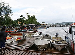
Gizo is the capital of the Western Province in Solomon Islands. With a population of 7,177, it is the third largest town in the country. It is situated on Ghizo Island approximately 380 kilometres west-northwest of the capital, Honiara, and is just southwest of the larger island of Kolombangara.

<span class="mw-page-title-main">Ranongga</span>

Ranongga is an island located in the New Georgia Islands group of Western Province, Solomon Islands.

<span class="mw-page-title-main">September 2007 Sumatra earthquakes</span> Earthquakes affecting Indonesia

The September 2007 Sumatra earthquakes were a series of megathrust earthquakes that struck the Sunda Trench off the coast of Sumatra, Indonesia, with three of magnitude 7 or greater. A series of tsunami bulletins was issued for the area. The most powerful of the series had a magnitude of 8.5, which makes it in the top 20 of the largest earthquakes ever recorded on a seismograph.

The 2009 Samoa earthquake and tsunami took place on 29 September 2009 in the southern Pacific Ocean adjacent to the Kermadec-Tonga subduction zone. The submarine earthquake occurred in an extensional environment and had a moment magnitude of 8.1 and a maximum Mercalli intensity of VI (Strong). It was the largest earthquake of 2009. The earthquake initiated with a normal-faulting event with a magnitude of 8.1. Within two minutes of the earthquake rupture, two large magnitude 7.8 earthquakes occurred on the subduction zone interface. The two magnitude 7.8 earthquakes had a combined magnitude equivalent to 8.0. The event can be considered a doublet earthquake.

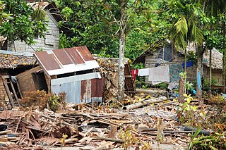
The 2010 Solomon Islands earthquake occurred with a moment magnitude of 7.1 on January 3 at 22:36:28 (UTC). A tsunami measuring approximately 10 feet affected some parts of the islands, while a maximum run-up height of 23.0 feet was recorded. The earthquake was the largest in a series of quakes to strike the Solomon Islands over the preceding days. The 7.1 mainshock was preceded by a 6.6 magnitude foreshock some 48 minutes previous. As many as 1,000 people were left homeless on the island of Rendova after the earthquake and tsunami destroyed approximately 200 homes.

<span class="mw-page-title-main">2010 Chile earthquake</span> Magnitude 8.8 earthquake in Chile on 27 February 2010

The 2010 Chile earthquake and tsunami occurred off the coast of central Chile on Saturday, 27 February at 03:34 local time, having a magnitude of 8.8 on the moment magnitude scale, with intense shaking lasting for about three minutes. It was felt strongly in six Chilean regions that together make up about 80 percent of the country's population. According to the United States Geological Survey (USGS) the cities experiencing the strongest shaking—VIII (Severe) on the Mercalli intensity scale (MM)—were Concepción, Arauco, and Coronel. According to Chile's Seismological Service, Concepción experienced the strongest shaking at MM IX (Violent). The earthquake was felt in the capital Santiago at MM VII or MM VIII. Tremors were felt in many Argentine cities, including Buenos Aires, Córdoba, Mendoza, and La Rioja. Tremors were felt as far north as the city of Ica in southern Peru.

The 1996 Biak earthquake, or the Irian Jaya earthquake, occurred on 17 February at 14:59:30 local time near Biak Island, Indonesia. The earthquake, which occurred on the New Guinea Trench, had a moment magnitude of 8.2 and a maximum Mercalli intensity of IX (Violent). The run-up height of the generated tsunami reached 7.7 m (25 ft). The disaster left at least 108 people dead, 423 injured, and 58 missing. It damaged or destroyed 5,043 houses which subsequently made another 10,000 homeless. At Korim, 187 houses were destroyed. Various countries and organizations provided aid and relief in the aftermath of the earthquake.

<span class="mw-page-title-main">2010 Mentawai earthquake and tsunami</span> 2010 Indonesian earthquake and tsunami

The 2010 Mentawai earthquake occurred with a moment magnitude of 7.8 on 25 October off the western coast of Sumatra at 21:42 local time. The earthquake occurred on the same fault that produced the 2004 Indian Ocean earthquake. It was widely felt across the provinces of Bengkulu and West Sumatra and resulted in a substantial localized tsunami that struck the Mentawai Islands.

The 2012 Indian Ocean earthquakes were magnitude 8.6 and 8.2 Mw  undersea earthquakes that struck near the Indonesian province of Aceh on 11 April at 15:38 local time. Initially, authorities feared that the initial earthquake would cause a tsunami and warnings were issued across the Indian Ocean; however, these warnings were subsequently cancelled. These were unusually strong intraplate earthquakes and the largest strike-slip earthquake ever recorded.

An earthquake off the coast of Samar occurred on August 31, 2012, at 20:47 local time in the Philippines. The populated islands of Visayas were struck by an earthquake of magnitude Mw 7.6. The earthquake occurred at a depth of 45 km. A tsunami warning was announced within the Pacific area and was lifted after two hours. The Philippine archipelago is located in the Pacific Ring of Fire, where earthquakes and volcanic activity are common.

The 2012 Haida Gwaii earthquake occurred just after 8:04 p.m. PDT on October 27. The shock had a moment magnitude of 7.8 and a maximum Mercalli Intensity of V (Moderate). The earthquake's epicentre was on Moresby Island of the Haida Gwaii archipelago. This was the second largest Canadian earthquake ever recorded by a seismometer, after the 1949 Queen Charlotte Islands earthquake, about 135 kilometres (84 mi) away. One person died due to a car crash related to the tsunami in Oahu, Hawaii.

<span class="mw-page-title-main">2013 Solomon Islands earthquake</span> Megathrust earthquake and tsunami in Solomon Islands

The 2013 Solomon Islands earthquake struck Temotu Province within Solomon Islands on 6 February with a moment magnitude of 8.0 and a maximum Mercalli intensity of VIII (Severe). The epicentre was close to the Santa Cruz Islands within Temotu Province at the boundaries of the Indo-Australian and Pacific tectonic plates, causing local evacuations, a tsunami of 11 m (36 ft) and killing at least ten people.

The 2014 Iquique earthquake struck off the coast of Chile on 1 April, with a moment magnitude of 8.2, at 20:46 local time. The epicenter of the earthquake was approximately 95 kilometres (59 mi) northwest of Iquique. The mainshock was preceded by a number of moderate to large shocks and was followed by a large number of moderate to very large aftershocks, including a M7.7 event on 3 April. The megathrust earthquake triggered a tsunami of up to 2.11 metres (6.9 ft) that hit Iquique at 21:05 local time. Similar-sized tsunamis were also reported to have hit the coasts of Pisagua and Arica.

<span class="mw-page-title-main">2016 Solomon Islands earthquakes</span> Seismic events

On 9 December 2016 at 4:38 a.m. local time, the Solomon Islands region was rocked by an Mww 7.8 earthquake, centered 30 km off San Cristobal Island, about 61 km southwest of Kirakira, the capital of Makira-Ulawa Province. Initially registering magnitude 8.0, later downgraded to 7.8, the temblor prompted tsunami warnings that kept countries surrounding the Coral, Tasman and Solomon Sea on high alert, but was later cancelled. A large aftershock of magnitude 6.9 occurred shortly afterwards. This earthquake was largely felt, waking many residents who later ran to high ground for fears of a potential tsunami. The earthquake killed a child and affected some 34,000 people in Makira, South Malaita and Guadalcanal Island where many had lost their homes or had no access to basic needs. Earthquakes are common in this region, with little or no fatalities. This earthquake is tied with three other magnitude 7.8 earthquakes for the second largest earthquake of 2016. On 17 December, the Solomon Islands would be rattled again by a 7.9 magnitude earthquake, this time 54 km east of Taron, Papua New Guinea.

The 2018 Fiji earthquakes occurred on August 19, at 00:19:40 UTC and on September 6 15:49 UTC. The epicenters were located close to the Fijian island Lakeba, and around 270 km from the small town of Levuka on Ovalau. The first earthquake registered a magnitude of Mww  8.2, and is the largest earthquake of 2018. It had a focal depth of 600 km, making it the second largest earthquake ever recorded at a depth greater than 300 km; a tie with the 1994 Bolivia earthquake, and behind the 2013 Okhotsk Sea earthquake. The initial earthquake was caused by a normal fault below the South Pacific Ocean. An Mww  7.9 event struck the islands again on September 6 at a depth of 670 km; this earthquake was a mainshock of its own. Both earthquakes may be considered a doublet event.

The 2021 Kermadec Islands earthquakes were a series of earthquakes with magnitudes of 8.1 and 7.4 that occurred at 19:28:31 UTC on 4 March 2021. The epicentres were located southeast of Raoul Island in the Kermadec Islands, part of the New Zealand outlying islands. The main magnitude 8.1 earthquake was preceded by a magnitude 7.4 foreshock and followed by a magnitude 6.1 aftershock. A separate, unrelated magnitude 7.3 earthquake occurred off the coast of the North Island of New Zealand, approximately 900 km to the south, several hours before the main quakes. More than a dozen aftershocks exceeded magnitude 6.

<span class="mw-page-title-main">2021 Chignik earthquake</span> 7th largest earthquake in the US

An earthquake occurred off the coast of the Alaska Peninsula on July 28, 2021, at 10:15 p.m. local time. The large megathrust earthquake had a moment magnitude of 8.2 according to the United States Geological Survey (USGS). A tsunami warning was issued by the National Oceanic and Atmospheric Administration (NOAA) but later cancelled. The mainshock was followed by a number of aftershocks, including three that were of magnitude 5.9, 6.1 and 6.9 respectively.

References

  1. 1 2 3 "Magnitude 8.1 - SOLOMON ISLANDS - Summary". USGS Earthquake Hazards Program. USGS. Archived from the original on 6 April 2007. Retrieved 2 April 2007.
  2. Furlong, K. P.; Lay, T.; Ammon, C. J. (2009). "A Great Earthquake Rupture Across a Rapidly Evolving Three-Plate Boundary". Science . 324 (5924): 226–229. Bibcode:2009Sci...324..226F. doi:10.1126/science.1167476. PMID   19359581. S2CID   7454410.
  3. "Deadly tsunami strikes Solomons". News Limited. 2 April 2007. Archived from the original on 3 September 2012. Retrieved 2 April 2007.
  4. "Towns evacuated amid tsunami panic". News Limited. 2 April 2007. Archived from the original on 9 February 2008. Retrieved 2 April 2007.
  5. Christopher Joyce (2 April 2007). "Tsunami Moved Too Quickly for Warning System". National Public Radio. Archived from the original on 6 April 2007. Retrieved 3 April 2007.
  6. Solomons quake and tsunami death toll reaches 52, Radio New Zealand, 16 April 2007
  7. "Report: Tsunami leaves thousands homeless in the hills". News Limited. 2 April 2007. Archived from the original on 4 September 2012. Retrieved 3 April 2007.
  8. Fritz, Hermann; Kalligeris, Nikos (2008). "Ancestral heritage saves tribes during 1 April 2007 Solomon Islands tsunami". Geophysical Research Letters. 35 (L01607): L01607. Bibcode:2008GeoRL..35.1607F. doi: 10.1029/2007GL031654 .
  9. "Report: Death toll in Solomons at 15". News Limited. 2 April 2007. Archived from the original on 9 February 2008. Retrieved 2 April 2007.
  10. "Report: Solomons tsunami aid stepped up". BBC News . 2 April 2007. Archived from the original on 7 April 2007. Retrieved 2 April 2007.
  11. "Houses float in sea of devastation". News Limited. 2 April 2007. Archived from the original on 3 December 2012. Retrieved 2 April 2007.
  12. Disease breaking out after Solomon Islands quake, Reuters, 5 April 2007
  13. Communicable diseases under control in Solomon Islands, ReliefWeb, 12 April 2007
  14. Measles immunization campaign begins in Solomon Islands, People's Daily Online, 18 April 2007
  15. Taylor, Frederick; Richard W. Briggs; Cliff Frohlich; Abel Brown; Matt Hornbach; Alison K. Papabatu; Aron J. Meltzner; Douglas Billy (2008). "Rupture across arc segment and plate boundaries in the 1 April 2007 Solomons earthquake". Nature Geoscience. 1 (4): 253–257. Bibcode:2008NatGe...1..253T. doi:10.1038/ngeo159.
  16. Sands, Neil. "Quake lifts Solomons island out of the sea". Yahoo! News. Yahoo! Inc. Archived from the original on 9 April 2007. Retrieved 9 April 2007.
  17. "Quake lifts Solomons island metres from the sea". Daily News & Analysis. 7 April 2007. Retrieved 7 April 2007.
  18. Indonesian coral reef exposed by 2005 earthquake, Associated Press, 14 April 2007
  19. "Australia provides $2.7 million for Solomon Islands post-tsunami reconstruction". 19 June 2007. Retrieved 11 November 2008.
  20. "Tsunami recovery package for Solomon Islands". 9 July 2007. Retrieved 11 November 2008.
  21. United States Pledges Assistance After Solomon Islands Tsunami Archived 28 November 2010 at the Wayback Machine , United States Department of State, 4 April 2007
  22. Solomon Islands: Taiwan boosts assistance to tsunami victims, ReliefWeb, 5 April 2007
  23. Solomon Islands Tsunami Aid Effort Gathers Pace [ permanent dead link ], Associated Press via ABC/KGO-TV, 6 April 2007
  24. Solomon Islands: UN aid workers start recovery efforts after tsunami, United Nations, 4 April 2007
  25. Tsunami relief bolstered for disease crisis Archived 9 February 2008 at the Wayback Machine , The Australian, 9 April 2007
  26. PNG joins in sending aid to Solomons, Radio Australia, 11 April 2007
  27. UNICEF: Urgent appeal for funds for hard hit Solomon Islands Archived 10 April 2007 at the Wayback Machine , UNICEF, 4 April 2007
  28. International Response to Solomon Islands Tsunami Victims Gathers Momentum Archived 11 April 2007 at the Wayback Machine , Voice of America News, 6 April 2007
  29. Aid still days away for Solomons homeless, Reuters, 4 April 2007
  30. More aid supplies are starting to reach Solomon Islands tsunami victims Archived 28 September 2007 at the Wayback Machine , Associated Press via WSTM-TV, 6 April 2007
  31. Shipwrecked aid workers rescued, Melbourne Herald Sun, 13 April 2007
  32. Taiwanese tsunami aid ship in Solomon Islands freed from reef where it ran aground, Associated Press, 14 April 2007
  33. Shift Simbo tsunami victims: Solomons MP, Australian Associated Press, 8 April 2007
  34. Solomons PM seeks tsunami assistance Archived 13 July 2012 at archive.today , Australian Associated Press, 16 April 2007
  35. Tsunami beacon to protect coast Archived 30 April 2007 at the Wayback Machine , The Australian, 13 April 2007

Further reading

PD-icon.svg This article incorporates public domain material from websites or documents of the United States Geological Survey .