
Ranongga is an island located in the New Georgia Islands group of Western Province, Solomon Islands.
Ranongga is an island located in the New Georgia Islands group of Western Province, Solomon Islands.
Ranongga was sighted in 1787 by sailors Read and Dale. [1]
On August 18, 1959, a seismic sea wave was generated off the west coast of Ranongga Island, at 08 hr 05 min. Soon after, large waves were observed in Vori, on the northern coast of the island. The sea receded by 15m and then returned to its original position. [2] In May 2007 there was another large earthquake, and tsunami, and the whole Island lifted out of the sea by 3 metres, and stayed there, exposing all of the reefs around the Island, making life very hard for the locals for some time after.
Ranongga is a 28 km (17 mi) long, narrow island, located 8 km (5 mi) north-east of Simbo Island and south-west of Gizo, the capital of Western Province. The highest point is Mt. Kela (869m) [1]
In April 2007, an earthquake rocked Ranongga Island, along with many parts of Solomon Islands. [3] Land thrust from the quake extended out the shoreline of Ranongga Island by up to 70 metres (230 ft) according to local residents. [4] This has left many once pristine coral reefs exposed on the newly formed beaches.
Most of the villages are situated on the eastern side of the island. The Ghanongga language is spoken by about 2,500 people on Ranongga Island.

Solomon Islands is an island country in the South Pacific Ocean, that lies east of Papua New Guinea.

The Andaman Sea is a marginal sea of the northeastern Indian Ocean bounded by the coastlines of Myanmar and Thailand along the Gulf of Martaban and the west side of the Malay Peninsula, and separated from the Bay of Bengal to its west by the Andaman Islands and the Nicobar Islands. Its southern end is at Breueh Island just north of Sumatra, with the Strait of Malacca further southeast.

A megatsunami is a very large wave created by a large, sudden displacement of material into a body of water.

The New Georgia Islands are part of the Western Province of Solomon Islands. They are located to the northwest of Guadalcanal. The larger islands are mountainous and covered in rain forest. The main islands are New Georgia, Vella Lavella, Kolombangara, Ghizo, Vangunu, Rendova and Tetepare. They are surrounded by coral reefs and include the Marovo Lagoon.
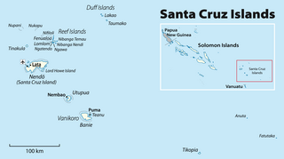
The Santa Cruz Islands is an archipelago in the Pacific Ocean, part of Temotu Province of the Solomon Islands. They lie approximately 250 miles to the southeast of the Solomon Islands archipelago. The Santa Cruz Islands lie just north of the archipelago of Vanuatu, and are considered part of the Vanuatu rain forests ecoregion.

On 26 December 2004, at 07:58:53 local time (UTC+7), a major earthquake with a magnitude of 9.2–9.3 Mw struck with an epicentre off the west coast of northern Sumatra, Indonesia. The undersea megathrust earthquake, known by the scientific community as the Sumatra–Andaman earthquake, was caused by a rupture along the fault between the Burma Plate and the Indian Plate, and reached a Mercalli intensity up to IX in some areas.
The 1929 Grand Banks earthquake occurred on November 18, 1929. The shock had a moment magnitude of 7.2 and a maximum Rossi–Forel intensity of VI and was centered in the Atlantic Ocean off the south coast of Newfoundland in the Laurentian Slope Seismic Zone.

Western Province is the largest of the nine provinces of Solomon Islands. The area is renowned for its beautiful tropical islands, excellent diving and snorkelling, coral reefs and World War II wrecks, ecotourism lodges, and head-hunting shrines. The province contains many small lagoons and most of the country's tourist trade outside Honiara.

An earthquake occurred on July 17, 2006 at 15:19:27 local time along a subduction zone off the coast of west and central Java, a large and densely populated island in the Indonesian archipelago. The shock had a moment magnitude of 7.7 and a maximum perceived intensity of IV (Light) in Jakarta, the capital and largest city of Indonesia. There were no direct effects of the earthquake's shaking due to its low intensity, and the large loss of life from the event was due to the resulting tsunami, which inundated a 300 km (190 mi) portion of the Java coast that had been unaffected by the earlier 2004 Indian Ocean earthquake and tsunami that was off the coast of Sumatra. The July 2006 earthquake was also centered in the Indian Ocean, 180 kilometers (110 mi) from the coast of Java, and had a duration of more than three minutes.
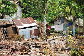
The 2007 Solomon Islands earthquake took place on 2 April 2007, near the provincial capital of Gizo on Ghizo Island, in the Solomon Islands. Its magnitude was estimated at 8.1 on the Mw scale, and 7.8 on the Ms scale. The tsunami that followed the earthquake killed 52 people. According to the USGS, the earthquake was recorded around 7:39:56 a.m. local time (UTC+11). The focus was 10 km (6 mi) deep and 40 km (25 mi) south southeast of Gizo township on New Georgia Islands in Western Province. There were numerous aftershocks, the largest of which had a magnitude of 6.2.

The September 2007 Sumatra earthquakes were a series of megathrust earthquakes that struck the Sunda Trench off the coast of Sumatra, Indonesia, with three of magnitude 7 or greater. A series of tsunami bulletins was issued for the area. The most powerful of the series had a magnitude of 8.4, which makes it in the top 20 of the largest earthquakes ever recorded on a seismograph.

The 2010 Chile earthquake and tsunami occurred off the coast of central Chile on Saturday, 27 February at 03:34:12 local time, having a magnitude of 8.8 on the moment magnitude scale, with intense shaking lasting for about three minutes. It was felt strongly in six Chilean regions that together make up about 80 percent of the country's population. According to the United States Geological Survey (USGS) the cities experiencing the strongest shaking—VIII (Severe) on the Mercalli intensity scale (MM)—were Concepción, Arauco, and Coronel. According to Chile's Seismological Service, Concepción experienced the strongest shaking at MM IX (Violent). The earthquake was felt in the capital Santiago at MM VII or MM VIII. Tremors were felt in many Argentine cities, including Buenos Aires, Córdoba, Mendoza, and La Rioja. Tremors were felt as far north as the city of Ica in southern Peru. It is the largest earthquake to hit Chile since the 1960 Valdivia earthquake.
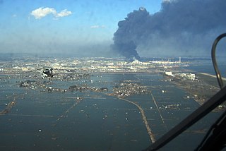
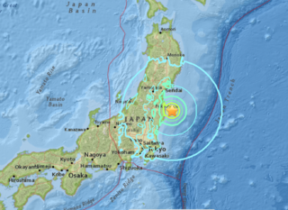
On 11 March 2011, at 14:46 JST, a Mw 9.0–9.1 undersea megathrust earthquake occurred in the Pacific Ocean, 72 km (45 mi) east of the Oshika Peninsula of the Tōhoku region. It lasted approximately six minutes and caused a tsunami. It is sometimes known in Japan as the "Great East Japan Earthquake", among other names. The disaster is often referred to by its numerical date, 3.11.
The 2012 Indian Ocean earthquakes were magnitude 8.6 and 8.2 Mw undersea earthquakes that struck near the Indonesian province of Aceh on 11 April at 15:38 local time. Initially, authorities feared that the initial earthquake would cause a tsunami and warnings were issued across the Indian Ocean; however, these warnings were subsequently cancelled. These were unusually strong intraplate earthquakes and the largest strike-slip earthquake ever recorded.
An earthquake off the coast of Samar occurred on August 31, 2012, at 20:47 local time in the Philippines. The populated islands of Visayas were struck by an earthquake of magnitude Mw 7.6. The earthquake occurred at a depth of 45 km. A tsunami warning was announced within the Pacific area and was lifted after two hours. The Philippine archipelago is located in the Pacific Ring of Fire, where earthquakes and volcanic activity are common.
The 2013 Solomon Islands earthquake struck Temotu Province within Solomon Islands on 6 February with a moment magnitude of 8.0 and a maximum Mercalli intensity of VIII (Severe). The epicentre was close to the Santa Cruz Islands within Temotu Province at the boundaries of the Indo-Australian and Pacific tectonic plates, causing local evacuations, a tsunami of 11 m (36 ft) and killing at least ten people.
The 2016 Fukushima earthquake struck Japan east-southeast of Namie, Fukushima Prefecture at 05:59 JST on November 22 with depth of 11.4 km (7.1 mi). The shock had a maximum intensity of VII (Very strong) on the Mercalli scale. The earthquake was initially reported as a 7.3 magnitude by Japan Meteorological Agency, and was later revised to 7.4, while the United States Geological Survey and GFZ Potsdam determined a magnitude of 6.9.
On the morning of March 13, 1888, an explosion took place on Ritter Island, a small volcanic island in the Bismarck and Solomon Seas, between New Britain and Umboi Island. The explosion resulted in the collapse of most of the island and generated a tsunami with runups of up to 15 meters (49 ft) that caused damage more than 700 kilometers (430 mi) away and killed anywhere between 500 and 3,000 on neighboring islands, including scientists and explorers. This event is the largest volcanic island sector collapse in recent history.
The 2021 Kermadec Islands earthquakes were a series of earthquakes with magnitudes of 8.1 and 7.4 that occurred at 19:28:31 UTC on 4 March 2021. The epicentres were located southeast of Raoul Island in the Kermadec Islands, part of the New Zealand outlying islands. The main magnitude 8.1 earthquake was preceded by a magnitude 7.4 foreshock and followed by a magnitude 6.1 aftershock. A separate, unrelated magnitude 7.3 earthquake occurred off the coast of the North Island of New Zealand, approximately 900 km to the south, several hours before the main quakes. More than a dozen aftershocks exceeded magnitude 6.
8°03′43″S156°34′05″E / 8.062°S 156.568°E
| | This Solomon Islands location article is a stub. You can help Wikipedia by expanding it. |