Rob Roy Island

Last updated
Location of Rob Roy Island (Bottom Right) and neighbouring islands Choiseulandneighbourhood.png
Location of Rob Roy Island (Bottom Right) and neighbouring islands

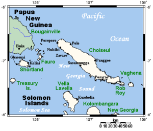
Rob Roy Island, native name Velaviru, is an island in Solomon Islands located off the South East coast of Choiseul Island; it is located in Choiseul Province. [1] [2]

Geography

The island is covered with coconut plantation and jungle. The island is 20 km long and has a summit elevation of 150 m. [3]

Nagosele Passage divides Rob Roy Island from Choiseul Island [4] [5] [6] [7]

Related Research Articles

<span class="mw-page-title-main">Baffin Bay</span> Marginal sea between Greenland and Baffin Island, Canada

Baffin Bay, located between Baffin Island and the west coast of Greenland, is defined by the International Hydrographic Organization as a marginal sea of the Arctic Ocean. It is sometimes considered a sea of the North Atlantic Ocean. It is connected to the Atlantic via Davis Strait and the Labrador Sea. The narrower Nares Strait connects Baffin Bay with the Arctic Ocean. The bay is not navigable most of the year because of the ice cover and high density of floating ice and icebergs in the open areas. However, a polynya of about 80,000 km2 (31,000 sq mi), known as the North Water, opens in summer on the north near Smith Sound. Most of the aquatic life of the bay is concentrated near that region.

<span class="mw-page-title-main">Solomon Islands rain forests</span>

The Solomon Islands rain forests are a terrestrial ecoregion covering the Solomon Islands archipelago.

<span class="mw-page-title-main">Matukituki River</span> River in the South Island of New Zealand

The Matukituki River is a short braided river in the Southern Alps of New Zealand's South Island. Both its West Branch and East Branch originate from the Main Divide mountain ranges near Mount Aspiring / Tititea. Their largely glacier-fed waters each flow for approximately 20 kilometres (12 mi) before joining near Camerons Flat. After this confluence, the Matukituki River leaves the boundaries of Mount Aspiring National Park and continues for another 30 kilometres (19 mi) to exit into Lake Wānaka at the lake's southwestern edge.

<span class="mw-page-title-main">Byrd Glacier</span> Glacier in Antarctica

The Byrd Glacier is a major glacier in Antarctica, about 136 km (85 mi) long and 24 km (15 mi) wide. It drains an extensive area of the Antarctic plateau, and flows eastward to discharge into the Ross Ice Shelf.

North Reef is a shallow reef south of Rennell Island. It is one of the three atolls that make up the Indispensable Reefs in the Rennell and Bellona Province of Solomon Islands.

<span class="mw-page-title-main">Choiseul Province</span> Province in Taro Island, Solomon Islands

Choiseul Province is one of the nine provinces of Solomon Islands. It lies southeast of Bougainville, west of Santa Isabel Island, and north of Vella la Vella, Kolombangra & New Georgia. It has a population of 36,719

<span class="mw-page-title-main">Choiseul pigeon</span> An extinct bird from the Solomon Islands

The Choiseul pigeon is an extinct species of bird in the pigeon and dove family, Columbidae. It was endemic to the island of Choiseul in the Solomon Islands, although there are unsubstantiated reports that it may once have lived on several nearby islands. The last confirmed sighting was in 1904. Other common names were Solomons crested pigeon, Solomon Islands crowned-pigeon and Kuvojo.

<span class="mw-page-title-main">Cape Horn</span> Headland of the Tierra del Fuego archipelago located in Chile

Cape Horn is the southernmost headland of the Tierra del Fuego archipelago of southern Chile, and is located on the small Hornos Island. Although not the most southerly point of South America, Cape Horn marks the northern boundary of the Drake Passage and marks where the Atlantic and Pacific Oceans meet.

<span class="mw-page-title-main">Choiseul Island</span> Island in the Solomon Islands

Choiseul Island, native name Lauru, is the largest island of the Choiseul Province, Solomon Islands, at 7.08°S 157°E. The administrative headquarters of Choiseul Province is situated in the town of Taro, on Taro Island.

<span class="mw-page-title-main">Arundel Island</span> Island in the Solomon Islands

Arundel Island is an island of the New Georgia Islands archipelago in the Western Province of Solomon Islands. Its indigenous names are Kohinggo and Ndokulu.

Cyprian Bridge Island is a small island located in Solomon Islands. The island lies at a latitude of -6.85S and a longitude of 156.18333E. It is an uninhabited volcanic island that lies between the islands of Fauro and Choiseul. The island lies within Choiseul Province.

<span class="mw-page-title-main">Solomon Archipelago</span> A marine ecoregion of the Pacific Ocean

The Solomon Archipelago is a terrestrial ecoregion and marine ecoregion in the Pacific Ocean. It includes the tropical ocean waters surrounding most of the Solomon Islands archipelago, and includes Bougainville Island and Buka Island of Papua New Guinea and their surrounding waters.

<span class="mw-page-title-main">Indispensable Reefs</span> Three atolls in Rennell and Bellona Province, Solomon Islands

The Indispensable Reefs are a chain of three large coral atolls in the Coral Sea. They are located about 50 km (30 mi) south of Rennell Island. The chain stretches over a length of 114 km (71 mi) and its average width is 18 km (11 mi).

Fenualoa is the second largest island in the Reef Islands, administratively located in the Solomon Islands province of Temotu.

Logha is an island of the Solomon Islands, that is located within the Western Province. The estimated terrain elevation above sea level is some 28 metres.

Vulelua is an island in Solomon Islands; it is located in Guadalcanal Province. There is a hotel in the island.

Arnarvon Islands are a group of islands in Solomon Islands. They are located in Isabel Province and nearby to Wagina Island in Choiseul Province.

Sikopo is an island in Solomon Islands; part of the Arnarvon Islands in Isabel Province. It lies in Manning Strait, which is between Choiseul Island and Santa Isabel Island, and which connects New Georgia Sound to the Pacific. The strait is named for Captain Edward Manning, of Pitt, who was the first European to sail through the straits and chart it in 1792.

Masamasa is an island of the Shortland Islands Archipelago, located in the Western Province of the Solomon Islands in the Pacific Ocean. The estimated terrain elevation above sea level is some 97 meters. To the east lies Fauro Island, to the south lies Piedu Island (Piru), and to the east lies the northern tip of Choiseul Island.

Tahua is a Duff Islands archipelago, located in the Temotu Province of the Solomon Islands in the Pacific Ocean. The estimated terrain elevation above sea level is some 23 metres. The island is inhabited.

References

  1. "Rob Roy Island: Solomon Islands". Geographic Names. Retrieved 4 August 2018.
  2. "Traveling Luck for Rob Roy Island". Traveling Luck. Retrieved 4 August 2018.
  3. http://www.solomonislands.com.sb/robroy.html googlecached version of website
  4. Excursion to Choiseul - Chapter Six — Page 53, Nagosele Passage, dividing Rob Roy Island from Choiseul, is in places less than 70 yards wide. Rob Roy rises steep from its waters, inaccessibly steep generally, but on the Choiseul side of the channel merges into shallow mangroved waters, providing hundreds of natural hideouts for small craft., Stepping Stones to the Solomons: the unofficial history of the 29th Battalion with the Second New Zealand Expeditionary Force in the Pacific., NZETC
  5. Nggosele Passage between Choiseul and Rob Roy Island experiences strong currents depending on the tides. Archived 2008-09-19 at the Wayback Machine , South East Choiseul and Vaghena, choiseul, Exploring Solomons
  6. Going through the passage between Rob Roy Island and Choiseul, May 12, 2009, by alan70, Panoramio
  7. "Going through the passage between Rob Roy Island and Choiseul". Geoview. Retrieved 4 August 2018.
Notes

7°25′S157°35′E / 7.417°S 157.583°E / -7.417; 157.583