
The Marshall Islands, officially the Republic of the Marshall Islands, is an island country west of the International Date Line and north of the equator in the Micronesia region in the Northwestern Pacific Ocean. The territory consists of 29 coral atolls and five islands, divided across two island chains: Ratak in the east and Ralik in the west. 97.87% of its territory is water, the largest proportion of water to land of any sovereign state. The country shares maritime boundaries with Wake Island to the north, Kiribati to the southeast, Nauru to the south, and the Federated States of Micronesia to the west. The capital and largest city is Majuro, home to approximately half of the country's population.

Solomon Islands is an island country in the South Pacific Ocean, that lies east of Papua New Guinea.

The United States Minor Outlying Islands is a statistical designation defined by the International Organization for Standardization's ISO 3166-1 code. The entry code is ISO 3166-2:UM. The minor outlying islands and groups of islands consist of eight United States insular areas in the Pacific Ocean and one in the Caribbean Sea.

Melanesia is a subregion of Oceania in the southwestern Pacific Ocean. It extends from New Guinea in the west to the Fiji Islands in the east, and includes the Arafura Sea.
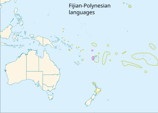
The Polynesian languages form a genealogical group of languages, itself part of the Oceanic branch of the Austronesian family.

Solomon Islands is a country consisting of six major islands and over 900 smaller islands in Melanesia, part of Oceania, to the northeast of Australia. It is directly adjacent to Papua New Guinea to the northwest, Australia to the southwest, New Caledonia and Vanuatu to the southeast, Fiji, Wallis and Futuna and Tuvalu to the east, Nauru and the Federated States of Micronesia to the north. It has a total area of 29,000 square kilometres, and a population of approximately 700,000. Its capital, Honiara, is located on the largest island, Guadalcanal. The country takes its name from the wider area of the Solomon Islands (archipelago), which is a collection of Melanesian islands that also includes the Autonomous Region of Bougainville, but excludes the Santa Cruz Islands.

Polynesian outliers are a number of culturally Polynesian societies that geographically lie outside the main region of Polynesian influence, known as the Polynesian Triangle; instead, Polynesian outliers are scattered in the two other Pacific subregions: Melanesia and Micronesia. Based on archaeological and linguistic analysis, these islands are considered to have been colonized by seafaring Polynesians, mostly from the area of Tonga, Samoa and Tuvalu.

The British Western Pacific Territories (BWPT) was a colonial entity created in 1877 for the administration of a series of Pacific islands in Oceania under a single representative of the British Crown, styled the High Commissioner for the Western Pacific. Except for Fiji and the Solomon Islands, most of these colonial possessions were relatively minor.
Sikaiana is a Polynesian language, spoken by about 730 people on Sikaiana in the Solomon Islands.
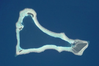
Ontong Java is a Polynesian language located on the Ontong Java Atoll, also known as the Luangiua Atoll or Lord Howe island, in the Solomon Islands. Two dialects, Luangiua and Pelau, are also spoken on the island. Ontong Java is commonly used by all speakers, young and old. There is approximately 2,370 residents of Ontong Java Atoll and has approximately 2,400 (estimated) speakers living on the atoll.

Severe Tropical Cyclone Namu was considered to be one of the worst tropical cyclones to impact the Solomon Islands on record, after it caused over 100 deaths within the island nations. It was first noted as a weak tropical depression to the north of the Solomon Islands during May 15, 1986. Over the next couple of days, the storm steadily intensified while meandering. After briefly moving west, the storm attained Category 2 intensity on the Australian intensity scale on May 18, as it moved through the island chain on the next day. Cyclone Namu attained peak intensity of 150 km/h (90 mph). After retaining its peak intensity for a day, Namu turned south and weakened steadily. By May 21, the winds of Cyclone Namu had been reduced to only 80 km/h (50 mph). Continuing to weaken, Namu turned east and dissipated on May 22, away from the island chain.
Faore is an island of the Sikaiana atoll in the Malaita Province, Solomon Islands in the South Pacific. The local name is Matuiloto.
Matuavi is an island of the Sikaiana atoll in the Malaita Province, Solomon Islands in the South Pacific.

The Coral reefs of the Solomon Islands consists of six major islands and over 986 smaller islands, in Oceania, to the east of Papua New Guinea and northwest of Vanuatu. The Solomon Islands lie between latitudes 5° and 13°S, and longitudes 155° and 169°E. The distance between the westernmost and easternmost islands is about 1,500 km (930 mi). The Santa Cruz Islands are situated north of Vanuatu and are especially isolated at more than 200 km (120 mi) from the other islands. The Solomon Islands has the 22nd largest Exclusive Economic Zone of 1,589,477 km2 (613,701 sq mi) of the Pacific Ocean.


