
Solomon Islands is an island country in the South Pacific Ocean, that lies east of Papua New Guinea.

Solomon Islands, also known simply as the Solomons, is a country consisting of six major islands and over 900 smaller islands in Melanesia, part of Oceania, to the northeast of Australia. It is directly adjacent to Papua New Guinea to the northwest, Australia to the southwest, New Caledonia and Vanuatu to the southeast, Fiji, Wallis and Futuna, and Tuvalu to the east, and Nauru and the Federated States of Micronesia to the north. It has a total area of 28,896 square kilometres, and a population of 734,887 according to the official estimates for mid 2023. Its capital, Honiara, is located on the largest island, Guadalcanal. The country takes its name from the wider area of the Solomon Islands archipelago, which is a collection of Melanesian islands that also includes the Autonomous Region of Bougainville, but excludes the Santa Cruz Islands.
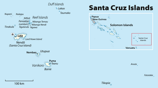
The Santa Cruz Islands are a group of islands in the Pacific Ocean, part of Temotu Province of the nation of Solomon Islands. They lie approximately 250 miles to the southeast of the Solomon Islands archipelago. The Santa Cruz Islands lie just north of the archipelago of Vanuatu, and are considered part of the Vanuatu rain forests ecoregion.

Polynesian outliers are a number of culturally Polynesian societies that geographically lie outside the main region of Polynesian influence, known as the Polynesian Triangle; instead, Polynesian outliers are scattered in the two other Pacific subregions: Melanesia and Micronesia. Based on archaeological and linguistic analysis, these islands are considered to have been colonized by seafaring Polynesians, mostly from the area of Tonga, Samoa and Tuvalu.
The Duff Islands are a small island group lying to the northeast of the Santa Cruz Islands in province of Temotu Province, in the nation of Solomon Islands. They are also sometimes known as the Wilson Islands.

Taumako is the largest of the Duff Islands, in the nation of Solomon Islands in the Pacific Ocean. This 5.7-kilometre-long (3.5-mile) island has steep sides and rises to a height of 400 metres above sea level. It is composed of basaltic lavas and pyroclastics like the other islands in the Duffs.

The Reef Islands are a loose collection of 16 islands in the in Temotu Province, in the independent nation of Solomon Islands. These islands have historically also been known by the names of Swallow Islands and Matema Islands.
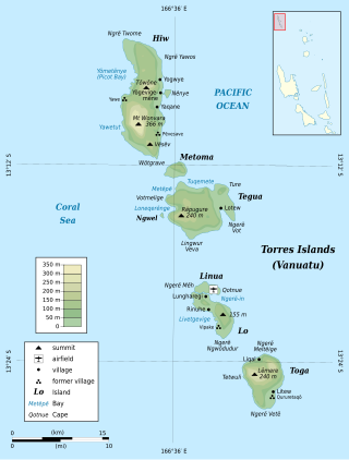
The Torres Islands are an island chain in the Torba Province of the country of Vanuatu, and is that country’s the northernmost island group. The chain of islands that make up this micro-archipelago straddles the broader cultural boundary between Island Melanesia and several Polynesian outliers located in the neighbouring Solomon Islands. To the island chain’s north is Temotu Province of the Solomon Islands, to its south is Espiritu Santo, and to its southeast are the Banks Islands. To the west, beneath the ocean surface, is the deep Torres Trench, which is the subduction zone between the Australian and Pacific plates.

A tepukei, tepuke or TePuke is a Polynesian boat type, characterized by its elaborate decking, its submerged hulls and symmetrical "crab claw" sail slender foil or radically extended tips claw sail. Tepukei boats are produced primarily by the Polynesian-speaking inhabitants of Taumako, and have been occasionally borrowed by other Polynesian and Melanesian societies.
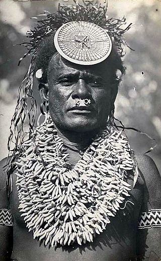
The culture of the Solomon Islands reflects the extent of the differentiation and diversity among the groups living within the Solomon Islands archipelago, which lies within Melanesia in the Pacific Ocean, with the peoples distinguished by island, language, topography, and geography. The cultural area includes the nation state of Solomon Islands and the Bougainville Island, which is a part of Papua New Guinea.

Temotu is the easternmost province of Solomon Islands. The province was formerly known as Santa Cruz Islands Province. It consists, essentially, of two chains of islands which run parallel to each other from the northwest to the southeast. Its area is 895 square kilometres.

The Temotu flying fox is a species of flying fox in the family Pteropodidae. It is endemic to the Solomon Islands. It is threatened by habitat destruction due to subsistence agricultural practices, as well as natural disasters such as tropical cyclones. Due to its imperiled status, it is identified by the Alliance for Zero Extinction as a species in danger of imminent extinction. In 2013, Bat Conservation International listed this species as one of the 35 species of its worldwide priority list of conservation.

Nukapu is one of the islands of the nation of Solomon Islands. It is in the Reef Islands group in Temotu Province; the easternmost province of the Solomons. The estimated terrain elevation above sea level is 15 metres.

Vanikoro is an island in the Santa Cruz group, located 118 kilometres to the Southeast of the main Santa Cruz group. It is part of the Temotu Province of Solomon Islands.
Nifiloli is an island in the Reef Islands, in Temotu Province, in the independent nation of Solomon Islands. The estimated terrain elevation above sea level is 19 metres. Despite its location in Melanesia, the population of the islands is Polynesian.
Matema Island or Matema is of one of the Reef Islands in Temotu Province, of the independent nation of Solomon Islands.

Nendö is the largest of the Santa Cruz Islands, located in the Temotu province of Solomon Islands. The island is also known as Santa Cruz, Nendo, Ndeni, Nitendi or Ndende. The name Santa Cruz was given to the island in 1595 by the Spanish navigator Álvaro de Mendaña, who started a colony there. Historically, the island has also been called New Guernsey and Lord Egmont's Island, after John Perceval, 2nd Earl of Egmont, First Lord of the Admiralty.
Bible translations into Oceanic languages have a relatively closely related and recent history.
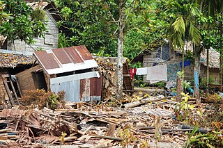
The 2013 Solomon Islands earthquake struck Temotu Province within Solomon Islands on 6 February with a moment magnitude of 8.0 and a maximum Mercalli intensity of VIII (Severe). The epicentre was close to the Santa Cruz Islands within Temotu Province at the boundaries of the Indo-Australian and Pacific tectonic plates, causing local evacuations, a tsunami of 11 m (36 ft) and killing at least ten people.
Tahua is one of the Duff Islands, of Temotu Province, in the independent nation of Solomon Islands. The estimated terrain elevation above sea level is some 23 metres. The island is inhabited.


