Related Research Articles

The Java Sea is an extensive shallow sea on the Sunda Shelf, between the Indonesian islands of Borneo to the north, Java to the south, Sumatra to the west, and Sulawesi to the east. Karimata Strait to its northwest links it to the South China Sea. It is a part of the western Pacific Ocean.
The Geologists Range is a mountain range about 55 km (34 mi) long, standing between the heads of Lucy and Nimrod Glaciers in Antarctica. Seen by the northern party of the New Zealand Geological Survey Antarctic Expedition (NZGSAE) (1961–62) and named to commemorate the work of geologists in Antarctic exploration. The Churchill Mountains are to the north, the Queen Elizabeth Range to the east and the Miller Range to the southeast

The Miller Range is a mountain range extending south from Nimrod Glacier for 80 km (50 mi) along the western edge of the Marsh Glacier in Antarctica.

The Byrd Glacier is a major glacier in Antarctica, about 136 km (85 mi) long and 24 km (15 mi) wide. It drains an extensive area of the Antarctic plateau, and flows eastward to discharge into the Ross Ice Shelf.

The Darwin Glacier is a large glacier in Antarctica. It flows from the polar plateau eastward between the Darwin Mountains and the Cook Mountains to the Ross Ice Shelf. The Darwin and its major tributary the Hatherton are often treated as one system, the Darwin–Hatherton.
The Darwin Mountains are a group of mountains between the Darwin Glacier and Hatherton Glacier in Antarctica. They were discovered by the British National Antarctic Expedition (1901–04) and named for Major Leonard Darwin, at that time Honorary Secretary of the Royal Geographical Society. They are south of the Cook Mountains and north of the Britannia Range

Koettlitz Glacier is a large Antarctic glacier lying west of Mount Morning and Mount Discovery in the Royal Society Range, flowing from the vicinity of Mount Cocks northeastward between Brown Peninsula and the mainland into the ice shelf of McMurdo Sound.

The Martin 156, referred to in the press variously as the "Russian Clipper", "Moscow Clipper", or "Soviet Clipper" was a very large flying boat aircraft intended for trans-Pacific service. The single example of the M-156 was designed and built in response to a request from Pan American World Airways to provide a longer-range replacement for the Martin M-130.

Coulman Island is an island 18 nautical miles long and 8 nautical miles wide, lying 9 nautical miles southeast of Cape Jones, Victoria Land, Antarctica, in the western Ross Sea. It was discovered in 1841 by Sir James Clark Ross who named it for his father-in-law, Thomas Coulman.
Scott Glacier is a glacier, 7 miles (11.3 km) wide and over 20 miles (32 km) long, flowing north-northwest to the Antarctic coast between Denman Glacier and Mill Island. It was discovered by the Western Base Party of the Australasian Antarctic Expedition (1911-1914) under Mawson and named for Capt. Robert F. Scott.
Carondelet Reef is a horseshoe-shaped reef, presumably a submerged atoll formation, of the Phoenix Islands, also known as the Rawaki Islands, in the Republic of Kiribati. It is located 106 kilometres southeast of Nikumaroro, at 05°34′S173°51′W, and has a least depth of 1.8 metres (5.9 ft). It is reported to be approximately 1.5 kilometres (0.9 mi) in length. The sea occasionally breaks over it.

Fauro Island is an island of the Shortland Islands archipelago, located in the Western Province of Solomon Islands, located at 6°55′S156°4′E. Along the center spine of the island are Mount Pauboleala with an elevation of 574 metres, Mount Lalauka with an elevation of 517 m, and Sharp Peak with an elevation of 484 m.

Ranongga is an island located in the New Georgia Islands group of Western Province, Solomon Islands.
Cyprian Bridge Island is a small island located in Solomon Islands. The island lies at a latitude of -6.85S and a longitude of 156.18333E. It is an uninhabited volcanic island that lies between the islands of Fauro and Choiseul. The island lies within Choiseul Province.
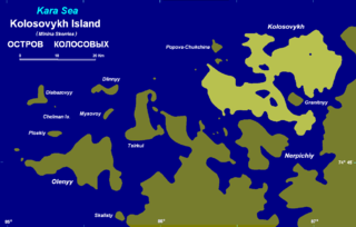
Kolosovykh Island is an island, in the Kara Sea off the coast of Siberia.

Harilaid Peninsula is a peninsula on the northwest coast of the island of Saaremaa in Estonia. It should not be confused with the islet of Harilaid which lies between the islands of Vormsi and Hiiumaa.
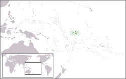
Liapari is an island in Western Province, in the independent nation of Solomon Islands..
The Song River is a river located in the Morobe Province of Papua New Guinea.
The Siki River is a river located in the Morobe Province of Papua New Guinea.
References
7°51′S156°29′E / 7.850°S 156.483°E
| | This Solomon Islands location article is a stub. You can help Wikipedia by expanding it. |