Related Research Articles

Solomon Islands, also known simply as the Solomons, is a country consisting of six major islands and over 900 smaller islands in Melanesia, part of Oceania, to the northeast of Australia. It is directly adjacent to Papua New Guinea to the northwest, Australia to the southwest, New Caledonia and Vanuatu to the southeast, Fiji, Wallis and Futuna, and Tuvalu to the east, and Nauru and the Federated States of Micronesia to the north. It has a total area of 28,896 square kilometres, and a population of 734,887 according to the official estimates for mid 2023. Its capital, Honiara, is located on the largest island, Guadalcanal. The country takes its name from the wider area of the Solomon Islands archipelago, which is a collection of Melanesian islands that also includes the Autonomous Region of Bougainville, but excludes the Santa Cruz Islands.

New Georgia Sound is the sound in the New Georgia Islands region that runs approximately southeast–northwest through the middle of the Solomon Islands archipelago in the Southern Pacific Ocean and Melanesia.

The Solomon Sea is a sea located within the Pacific Ocean. It lies between Papua New Guinea and Solomon Islands. Many major battles were fought there during World War II.
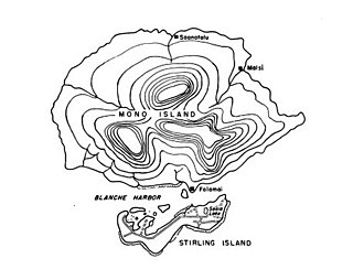
Treasury Islands are a small group of islands a few kilometres to the south of Bougainville and 24 kilometres from the Shortland Islands. They form part of the Western Province of the country of Solomon Islands. The two largest islands in the Treasuries are Mono Island and the smaller Stirling Island. The deep water strait between these two islands is called Blanche Harbor.

The North Solomon Islands form a geographical area covering the more northerly group of islands in the Solomon Islands archipelago and includes Bougainville and Buka Islands, Choiseul, Santa Isabel, the Shortland Islands and Ontong Java Atoll. In 1885 Germany declared a protectorate over these islands forming the German Solomon Islands Protectorate. With the exception of Bougainville and Buka, these were transferred to the British Solomon Islands Protectorate in 1900. Bougainville and Buka continued under German administration until the outset of World War I, when they were transferred to Australia, and after the war, were formally passed to Australian jurisdiction under a League of Nations mandate.
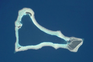
Sikaiana is a small atoll 212 kilometres NE of Malaita in Solomon Islands in the south Pacific Ocean. It is almost 14 kilometres in length and its lagoon, known as Te Moana, is totally enclosed by the coral reef. Its total land surface is only 2 square kilometres. There is no safe anchorage close to this atoll, which makes it often inaccessible to outsiders.

Marovo Lagoon is the largest saltwater lagoon in the world. Located in the New Georgia Islands, surrounded by Vangunu Island and Nggatokae Island, both extinct volcanic islands, at 8.48°S 158.07°E. It is part of the Solomon Islands. It encompasses 700 km2 (270 sq mi) and is protected by a double barrier reef system. Marovo Lagoon is identified as an area with high biodiversity and conservation values.

Nggatokae Island is an island in the New Georgia Islands within Western Province, Solomon Islands. It is served by Gatokae Aerodrome.

Solomon Warriors FC is a Solomon Islands professional football club based in Honiara. The club plays in the Telekom S-League, the top-tier in Solomon Islands football. They play their matches at Lawson Tama Stadium, the biggest stadium in the Solomon Islands.
Mbulo is an island in Western Province, Solomon Islands. Lying in the eastern part of the New Georgia Islands, Mbulo is heavily forested with a volcanic center. The terrain elevation above sea level has been estimated to be about 125 metres, but SRTM data suggests a maximum elevation of about 240 metres.
Kingguru is an island in the Solomon Islands; it is located in the Western Province.
Marovo Island is an island in the Solomon Islands. It is located in the Western Province. Marovo was the island where Australian sailor and author John Cromar mostly operated in his later years.
Arnarvon Islands are a group of islands in Solomon Islands. They are located in Isabel Province and nearby to Wagina Island in Choiseul Province.
Kerehikapa is an island in Solomon Islands; it is located in Isabel Province. It is part of the Marine Protected Area of Arnarvon Islands.

Rekata Bay, also known as Suavanau, is a bay located on the northeast coast of Santa Isabel Island in the Solomon Islands between Santa Isabel and Papatura Island.

Stathmopoda is a genus of moths. It has variously been placed in its own family, Stathmopodidae, or in subfamily Stathmopodinae in the family Oecophoridae. Note that the phylogeny and systematics of gelechoid moths are still not fully resolved.
TXS 0506+056 is a very high energy blazar – a quasar with a relativistic jet pointing directly towards Earth – of BL Lac-type. With a redshift of 0.3365 ± 0.0010, it has a luminosity distance of about 1.75 gigaparsecs. Its approximate location on the sky is off the left shoulder of the constellation Orion. Discovered as a radio source in 1983, the blazar has since been observed across the entire electromagnetic spectrum.
Pirumeri Island is an island of the Shortland Islands archipelago, located in the Western Province of the Solomon Islands is the Pacific Ocean. The estimated terrain elevation above sea level is some 25 metres.

The Coral reefs of the Solomon Islands consists of six major islands and over 986 smaller islands, in Oceania, to the east of Papua New Guinea and northwest of Vanuatu. The Solomon Islands lie between latitudes 5° and 13°S, and longitudes 155° and 169°E. The distance between the westernmost and easternmost islands is about 1,500 km (930 mi). The Santa Cruz Islands are situated north of Vanuatu and are especially isolated at more than 200 km (120 mi) from the other islands. The Solomon Islands has the 22nd largest Exclusive Economic Zone of 1,589,477 km2 (613,701 sq mi) of the Pacific Ocean.
References
- ↑ "Solomon Islands / Maleivona". Latitude. Retrieved 26 July 2018.
7°29′02″S158°03′02″E / 7.4838°S 158.0506°E
| | This Solomon Islands location article is a stub. You can help Wikipedia by expanding it. |