
Guadalcanal is the principal island in Guadalcanal Province of Solomon Islands, located in the southwestern Pacific Ocean, northeast of Australia. It is the largest island in the Solomons by area and the second-largest by population. The island is mainly covered in dense tropical rainforest and has a mountainous hinterland.

New Georgia, with an area of 2,037 km2 (786 sq mi), is the largest of the islands in Western Province, Solomon Islands, and the 224th-largest island in the world. Since July 1978, the island has been part of the independent state of Solomon Islands.

USS S-45 (SS-156) was a third-group (S-42) S-class submarine of the United States Navy.
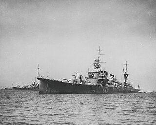
Furutaka was the lead ship in the two-vessel Furutaka-class of heavy cruisers in the Imperial Japanese Navy. The ship was named after Mount Furutaka, located on Etajima, Hiroshima immediately behind the Imperial Japanese Navy Academy. She was commissioned in 1926 and was sunk 12 October 1942 by USS Salt Lake City and USS Buchanan at the Battle of Cape Esperance.

Vella Lavella is an island in Western Province, in the independent nation of Solomon Islands. It lies to the west of New Georgia, but is considered one of the New Georgia Group. To its west are the Treasury Islands.
The Shortland Islands is an archipelago of Western Province, Solomon Islands, at 6.92°S 155.88°E. The island group lies in the extreme north-west of the country's territory, close to the south-east edge of Bougainville Island, Papua New Guinea.

Yura (由良) was the fourth of the six ships completed in the Nagara class of light cruisers for the Imperial Japanese Navy (IJN), and like other vessels of her class, she was intended for use as the flagship of a destroyer flotilla. She served in the early stages of World War II.

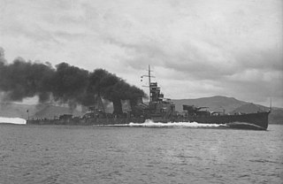
Kinugasa (衣笠) was the second vessel in the two-vessel Aoba class of heavy cruisers in the Imperial Japanese Navy. The ship was named after Mount Kinugasa, located in Yokosuka, Kanagawa, Japan.

Kako (加古) was the second vessel in the two-vessel Furutaka class of heavy cruisers in the Imperial Japanese Navy. The ship was named after the Kako River in Hyogo prefecture, Japan.

Kuroshio was the third vessel to be commissioned in the 19-vessel Kagerō-class destroyers built for the Imperial Japanese Navy in the late-1930s under the Circle Three Supplementary Naval Expansion Program.
Oyashio was the fourth vessel to be commissioned in the 19-vessel Kagerō-class destroyers built for the Imperial Japanese Navy in the late 1930s under the Circle Three Supplementary Naval Expansion Program.

Kagerō was the lead ship of the 19-vessel Kagerō-class destroyers built for the Imperial Japanese Navy in the late-1930s under the Circle Three Supplementary Naval Expansion Program.
Aoba (青葉) was the lead ship in the two-vessel Aoba class of heavy cruisers in the Imperial Japanese Navy. Launched in 1926 and heavily modernized in 1938-40, Aoba initially served as a patrol craft, largely along the China coast, and saw extensive service during World War II. Repeatedly heavily damaged and repaired, she was finally crippled by bombing and settled on the bottom of shallow Kure harbor in April 1945; two raids in late July reduced her to an unsalvageable hulk. During the attack on 24 July 1945, future Vice admiral Dick H. Guinn dropped the 2,000 lb (910 kg) bomb which contributed to her sinking.
Balalae Airport is a small civil airport on Balalae island operated by Solomon Airlines. It is located in the northwest of the Solomon Islands, part of the Shortland Island Group and south of Bougainville Island. It serves the nearby Shortland Islands and Fauro Island. It's a 1.75 km long sandy coral airstrip only 5 feet above sea level with a small customs area. It was built by prisoners of war, mostly British captured during the siege of Singapore, under the command of the Japanese during their occupation of the Solomons to protect the stronghold of Rabaul. In about June 1943, all Allied prisoners remaining on the island were killed and buried in mass graves. 436 bodies of unidentified soldiers were exhumed post-war. During 1943, Admiral Yamamoto planned to arrive on the airport from Rabaul to increase morale after the defeat at the Battle of Guadalcanal. He was shot down while passing Bougainville Island during Operation Vengeance, during the Guadalcanal campaign.
Cyprian Bridge Island is a small island located in Solomon Islands. The island lies at a latitude of -6.85S and a longitude of 156.18333E. It is an uninhabited volcanic island that lies between the islands of Fauro and Choiseul. The island lies within Choiseul Province.
Faisi is a small island in the Western Province of Solomon Islands. The island is a part of Shortland Islands archipelago.
Ovau Island is an island of the Shortland Islands archipelago, in Western Province, in the independent nation of Solomon Islands. The estimated terrain elevation above sea level is some 309 metres.
Pirumeri Island is an island of the Shortland Islands archipelago, in Western Province, in the independent nation of Solomon Islands. The estimated terrain elevation above sea level is some 25 metres.
Magusaiai is an island in the Shortland Islands archipelago, in Western Province, in the independent nation of Solomon Islands. The estimated terrain elevation above sea level is some 14 metres.
Masamasa is an island of the Shortland Islands Archipelago, located in the Western Province of Solomon Islands in the Pacific Ocean. The estimated terrain elevation above sea level is some 97 meters. To the east lies Fauro Island, to the south lies Piedu Island (Piru), and to the east lies the northern tip of Choiseul Island.
