Anuta

Last updated

Anuta (Anuda)
Nickname: Cherry Island
Anuta 169.85030E 11.61124S.png
NASA Satellite Image Geocover 2000
Map of the Santa Cruz Islands (Solomon Islands).png
Santa Cruz Islands overview map
Geography
Location Pacific Ocean
Coordinates 11°36′39″S169°51′01″E / 11.61083°S 169.85028°E / -11.61083; 169.85028
ArchipelagoSolomon Islands
Area0.37 km2 (0.14 sq mi)
Length0.876 km (0.5443 mi)
Width0.576 km (0.3579 mi)
Highest elevation65 m (213 ft)
Administration
Province Temotu province flag.svg  Temotu
Largest settlementMua(pop. 200)
Demographics
Population300
Pop. density811/km2 (2100/sq mi)
Ethnic groups Polynesians

Anuta is a small volcanic island in the province of Temotu in the southeastern part of Solomon Islands. It is one of the smallest permanently inhabited Polynesian islands. [1] It is one of the Polynesian Outlier communities in Melanesia.

Contents

Geography

Pacific Ocean laea location map.svg
Cercle rouge 100%25.svg
Anuta
Location of Anuta in the Pacific Ocean

The island lies about 500 km (310 mi) to the east-southeast of Nendö. It is a small volcanic island with a fringing coral reef. The highest point on the island is 65 m (213 ft) above sea level. The island has a diameter of only about 750 m (820 yd) and an area of 0.4 square kilometres.

The island lies halfway between the Solomon Islands archipelago and Tuvalu. Anuta's nearest populated neighbour is Tikopia Island, about 112 kilometres to the southwest. The next closest islands are Vanikolo, Utupua, and the Reef Islands—with mixed Melanesian and Polynesian populations—and the Duff Islands, all over 320 kilometres away. Further southwest lie the Banks and New Hebrides Groups. [2]

History

Anuta was first mentioned in 1791, and the political and geographical circumstances led to isolation of Anuta's population. [3]

According to oral traditions, Anuta was settled by voyagers from Tonga and 'Uvea about fifteen generations ago. The time frame of the migration is not precisely identified but is understood to be some time between the 10th century and the mid-13th century, [4] although the arrival of the voyagers in Anuta could have occurred later. The pattern of settlement that is believed to have occurred is that the Polynesians spread out from Tonga and other islands in the central and southeastern Pacific islands. During pre-European-contact times, there was frequent canoe voyaging between the islands, because Polynesian navigation skills are recognised to have allowed deliberate journeys on double-hull sailing canoes or outrigger canoes. [5] The voyagers moved into the Tuvaluan atolls, with Tuvalu providing a stepping-stone to migration into the Polynesian Outlier communities in Melanesia and Micronesia. [6] [7] [8]

One of the Tongan settlers, Pu Kaurave, became the first chief, and was succeeded by his son Ruokimata. When Ruokimata died without an heir, Taroaki, one of the 'Uvean arrivals, became the next chief. [9] Further arrivals from Samoa and Tonga occurred two generations after the initial settlers. [9] The current social structure was established in the sixth generation when chief Tearakura, his two brothers, and one brother-in-law slew the remainder of the island's male population. These men, along with Tearakura's two sisters, were founders of the island's four kainanga, large descent groups that are sometimes described in English as 'clans'. Another group arrived from Rotuma some time later. [9]

Anglican missionaries arrived in 1916, quickly converting the entire island. [9] During the 1990s, Anuta's advisers rejected western medicines on the island, arguing that it would indicate a lack of faith in the church. [3] Administratively, Anuta is part of the Anglican Church of Melanesia Diocese of Temotu.

In December 2002, the island was impacted by Cyclone Zoe. [10]

Society and culture

Anuta has a human population of about 300. This is one of the highest population densities in the world, perhaps equalling that of Bangladesh. [11]

The island has two systems for naming villages (noporanga, or "dwelling places"). In one system there are three villages called Mua, Muri, and St. John. Mua, meaning "front", is to the east. Muri, meaning "back" is west of Mua. After establishment of the Anglican church in 1916, a third village grew up to the west of Muri and took the name of the church, St. John. In the second system, Mua and Muri are combined under the name, Rotoapi, and contrasted with the new village which, in the second system, is called Vatiana. Anutans use the uninhabited island of Fatutaka, about 60 km (37 mi) to the southeast, as a place to hunt birds.

Language

Anutans speak the Anuta language (locally te taranga paka-Anuta), which is related to other Polynesian languages.

Relationship with environment

An important value in Anutan society is aropa, which emphasizes collaboration, sharing and compassion for others. The concept of aropa encourages islanders to share their finite resources equitably. [12] [13] Because Anuta's high population density has not had a severely negative impact on the island's ecosystem, Anuta has attracted interest from scientists interested in sustainability. The BBC documentary series South Pacific devotes part of Episode 2 (Castaways) to the ability of Anutans to maintain their island's bounty, contrasting it with the environmental destruction found on Easter Island.

The Anuta people take care to fulfil their needs with respect to the environment, to preserve it. At certain times they do not catch certain fish or hunt animals. [14]

Social life

Like most of the other Polynesian islands, Anuta has traditions of choral polyphonic singing. Free time is spent dancing, singing and swimming. [14]

Research and media exposure

Anthropologist Raymond Firth visited Anuta for a day in 1952. Ethnobotanist Douglas Yen, along with archaeologists Patrick Kirch and Paul Rosendahl, [15] [16] spent about two months there in 1971, and anthropologist Richard Feinberg lived on Anuta for almost a year in 1972–1973. He has remained in communication with the Anutan community from that time onward and has made several additional visits.

Five documentaries about Anuta have been created. [17] In January 2005 Italian documentarists Elisabetta (Lizzi) Eordegh and Carlo Auriemma sailed aboard the sailing boat "Barca Pulita" with a crew of four (including two doctors) and visited the island for one week. [18] In 2006, Bruce Parry of the BBC visited for several weeks, during which he and his team filmed an episode of the TV show, Tribe . [13] In 2008, another film team from the BBC made a brief visit, and in 2012 a team from the Seoul Broadcasting System filmed a TV show there for a Korean audience. [19] In 2013, the team and crew of the Canadian documentary 1000 jours pour la planète arrived on the island with the anthropologist Richard Feinberg.

See also

Related Research Articles

<span class="mw-page-title-main">Demographics of Tuvalu</span>

Demographic features of the population of Tuvalu include the age structure, ethnicity, education level, life expectancy, religious affiliations and other aspects of the population.

<span class="mw-page-title-main">Polynesian languages</span> Language family

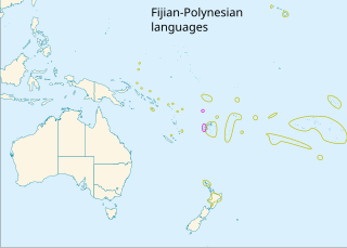
The Polynesian languages form a genealogical group of languages, itself part of the Oceanic branch of the Austronesian family.

Polynesians are an ethnolinguistic group of closely related ethnic groups who are native to Polynesia, an expansive region of Oceania in the Pacific Ocean. They trace their early prehistoric origins to Island Southeast Asia and form part of the larger Austronesian ethnolinguistic group with an Urheimat in Taiwan. They speak the Polynesian languages, a branch of the Oceanic subfamily of the Austronesian language family. The Indigenous Māori people constitute the largest Polynesian population, followed by Samoans, Native Hawaiians, Tahitians, Tongans and Cook Islands Māori

<span class="mw-page-title-main">Lapita culture</span> Neolithic archaeological culture in the Pacific

The Lapita culture is the name given to a Neolithic Austronesian people and their distinct material culture, who settled Island Melanesia via a seaborne migration at around 1600 to 500 BCE. The Lapita people are believed to have originated from the northern Philippines, either directly, via the Mariana Islands, or both. They were notable for their distinctive geometric designs on dentate-stamped pottery, which closely resemble the pottery recovered from the Nagsabaran archaeological site in northern Luzon. The Lapita intermarried with the Papuan populations to various degrees, and are the direct ancestors of the Austronesian peoples of Polynesia, eastern Micronesia, and Island Melanesia.
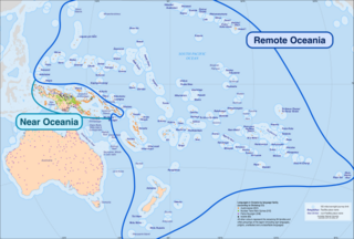
The Samoic–Outlier languages, also known as Samoic languages, are a purported group of Polynesian languages, encompassing the Polynesian languages of Samoa, Tuvalu, American Samoa, Tokelau, Wallis and Futuna, and Polynesian outlier languages in New Caledonia, the Solomon Islands, Vanuatu, Papua New Guinea, and the Federated States of Micronesia. The name "Samoic-Outlier" recognizes Samoan.

<span class="mw-page-title-main">Polynesian outlier</span> Polynesian societies outside the main region

Polynesian outliers are a number of culturally Polynesian societies that geographically lie outside the main region of Polynesian influence, known as the Polynesian Triangle; instead, Polynesian outliers are scattered in the two other Pacific subregions: Melanesia and Micronesia. Based on archaeological and linguistic analysis, these islands are considered to have been colonized by seafaring Polynesians, mostly from the area of Tonga, Samoa and Tuvalu.

<span class="mw-page-title-main">Fatutaka</span>

Fatutaka, Fatu Taka or Patu Taka is a small volcanic island in Temotu Province, in the nation of Solomon Islands, south-west Pacific Ocean. The easternmost island in Solomon Islands, Fatutaka is located c. 32 km (20 mi) southeast of Anuta and can be seen from there in clear weather. Fatutaka and Anuta were discovered for Europeans by Admiral Edward Edwards in 1791.

<span class="mw-page-title-main">Taumako</span> Island in Temotu Province, Solomon Islands

Taumako is the largest of the Duff Islands, in the nation of Solomon Islands in the Pacific Ocean. This 5.7-kilometre-long (3.5-mile) island has steep sides and rises to a height of 400 metres above sea level. It is composed of basaltic lavas and pyroclastics like the other islands in the Duffs.

<span class="mw-page-title-main">Tikopia</span> Island in the far southern Solomon Islands

Tikopia is a volcanic island in Temotu Province, in the independent nation of Solomon Islands, southwestern Pacific Ocean. Although most of Solomon Islands is Melanesian, Tikopia is culturally Polynesian. The first Europeans arrived on 22 April 1606 as part of the Spanish expedition of Pedro Fernandes de Queirós.

<span class="mw-page-title-main">Culture of the Solomon Islands</span>

The culture of the Solomon Islands reflects the extent of the differentiation and diversity among the groups living within the Solomon Islands archipelago, which lies within Melanesia in the Pacific Ocean, with the peoples distinguished by island, language, topography, and geography. The cultural area includes the nation state of Solomon Islands and the Bougainville Island, which is a part of Papua New Guinea.

<span class="mw-page-title-main">Temotu Province</span> Province in Lata, Solomon Islands

Temotu is the easternmost province of Solomon Islands. The province was formerly known as Santa Cruz Islands Province. It consists, essentially, of two chains of islands which run parallel to each other from the northwest to the southeast. Its area is 895 square kilometres.

Patrick Vinton Kirch is an American archaeologist and Professor Emeritus of Integrative Biology and the Class of 1954 Professor of Anthropology at the University of California, Berkeley. He is also the former Curator of Oceanic Archaeology in the Phoebe A. Hearst Museum of Anthropology, and director of that museum from 1999 to 2002. Currently, he is professor in the department of anthropology at the University of Hawai'i Manoa, and a member of the board of directors of the Bishop Museum.

<span class="mw-page-title-main">Polynesian navigation</span> Methods to navigate the Pacific Ocean

Polynesian navigation or Polynesian wayfinding was used for thousands of years to enable long voyages across thousands of kilometres of the open Pacific Ocean. Polynesians made contact with nearly every island within the vast Polynesian Triangle, using outrigger canoes or double-hulled canoes. The double-hulled canoes were two large hulls, equal in length, and lashed side by side. The space between the paralleled canoes allowed for storage of food, hunting materials, and nets when embarking on long voyages. Polynesian navigators used wayfinding techniques such as the navigation by the stars, and observations of birds, ocean swells, and wind patterns, and relied on a large body of knowledge from oral tradition. This island hopping was a solution against the scarcity of useful resources, such as food, wood, water, and available land, on the small islands in the Pacific Ocean. When an island’s required resources for human survival began to run low, the island's inhabitants used their maritime navigation skills and set sail for a new island full of possibilities. However, as an increasing number of islands in the South Pacific became occupied, and citizenship and national borders became of international importance, this was no longer possible. People thus became trapped on islands with the inability to support them.

<span class="mw-page-title-main">Roger Green (archaeologist)</span> American-born New Zealand archaeologist (1932–2009)

Roger Curtis Green was an American-born, New Zealand-based archaeologist, professor emeritus at The University of Auckland, and member of the National Academy of Sciences and Royal Society of New Zealand. He was awarded the Hector and Marsden Medals and was an Officer of the New Zealand Order of Merit for his contributions to the study of Pacific culture history.

The Tikopia language is a Polynesian Outlier language from the island of Tikopia in the Solomon Islands. It is closely related to the Anuta language of the neighboring island of Anuta. Tikopian is also spoken by the Polynesian minority on Vanikoro, who long ago migrated from Tikopia.

The Anuta language is a Polynesian Outlier language from the island of Anuta in the Solomon Islands. It is closely related to the Tikopia language of the neighboring island of Tikopia, and it bears significant cultural influence from the island. The two languages have a high degree of mutual intelligibility, although Anutans can understand Tikopians better than the reverse.

<span class="mw-page-title-main">Polynesia</span> Subregion of Oceania

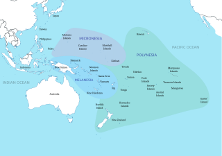
Polynesia is a subregion of Oceania, made up of more than 1,000 islands scattered over the central and southern Pacific Ocean. The indigenous people who inhabit the islands of Polynesia are called Polynesians. They have many things in common, including language relatedness, cultural practices, and traditional beliefs. In centuries past, they had a strong shared tradition of sailing and using stars to navigate at night.

Nuguria (Nukuria) was a Polynesian language, spoken by approximately 550 people on Nuguria in the eastern islands of Papua New Guinea. The language was taught in primary schools in Nuguria and was used for daily communications between adults and children. Nuguria is one of the eighteen small islands to the east of Papua New Guinea, which are known as the Polynesian Outliers. The Nukuria language has been concluded to be closely related to other nearby languages such as Nukumanu, Takuu, Nukuoro, and Luangiua. Research on the Nuguria Atoll and the language itself is scarce; past research demonstrated that this language was at risk of potential endangerment. The language was only then classified as at risk of endangerment because it was still used between generations and was passed on to the children. However, recent research indicates that Nukuria is now most likely an extinct language.

<span class="mw-page-title-main">Timeline of the history of Tuvalu</span> Timeline of notable events in the history of Tuvalu

This timeline of the history of Tuvalu chronologically lists important events occurring within the present political boundaries of the Pacific island state of Tuvalu. This time line is introduced by the theories as to the origins of the Polynesian people and the migration across the Pacific Ocean to create Polynesia, which includes the islands of Tuvalu.

Richard "Rick" Feinberg is an American anthropologist, writer, educator, and Emeritus Professor focusing on sociocultural anthropology, specifically on Polynesian societies in the Pacific Islands and Native North America. Feinberg completed his Bachelor of Arts at the University of California, Berkeley, in 1969, going on to obtain his Master of Arts in 1971 and a Doctor of Philosophy degree in 1974, both from the University of Chicago.

References

  1. Jared Diamond, Guns, Germs and Steel (Norton) 1997, p. 59.
  2. "Anuta Island". Solomon Islands Historical Encyclopaedia 1893-1978. Retrieved 5 August 2018.
  3. 1 2 BBC (March 2008). "The island of Anuta".
  4. Kennedy, Donald G. (1929). "Field Notes on the Culture of Vaitupu, Ellice Islands". Journal of the Polynesian Society. 38: 2–5.
  5. Bellwood, Peter (1987). The Polynesians – Prehistory of an Island People. Thames and Hudson. pp. 39–44.
  6. Bellwood, Peter (1987). The Polynesians – Prehistory of an Island People. Thames and Hudson. pp. 29, 54. ISBN   0500274509.
  7. Bayard, D.T. (1976). The Cultural Relationships of the Polynesian Outiers. Otago University, Studies in Prehistoric Anthropology, Vol. 9.
  8. Kirch, P.V. (1984). "The Polynesian Outiers". Journal of Pacific History. 95 (4): 224–238. doi:10.1080/00223348408572496.
  9. 1 2 3 4 It took an delection to bring Anuta into the outside world Pacific Islands Monthly, July 1973, p41
  10. Malcolm Brown and Sarah Crichton (2 January 2003). "Devastated islands languish as cyclone relief stuck in port". The Sydney Morning Herald.
  11. "Anuta – An Island Governed By Love". BBC Radio 4. Retrieved 14 October 2009.
  12. See Feinberg 2012.
  13. 1 2 "BBC – Tribe – Anuta" . Retrieved 7 June 2013.
  14. 1 2 Stephenson, Carol; Bradley, Harriet (2009). Business in Society. p. 41. ISBN   9780745642321.
  15. Kirch, Patrick Vinton; Yen, D.E. (1982), Tikopia; The Prehistory and Ecology of a Polynesian Outlier , Honolulu, Hawaii: Bishop Museum Press, ISBN   9780910240307
  16. Kirch, Patrick Vinton; D. Steadman and D. S. Pahlavan (1990), Extinction, biogeography, and human exploitation of birds on Anuta and Tikopia, Solomon Islands, Honolulu, Hawaii: Occasional Papers of the Bishop Museum 30:118–153
  17. "Anuta in the media – ANUTA COMMUNITY".
  18. "Barca Pulita - Anuta". Archived from the original on 21 February 2014. Retrieved 10 February 2014.
  19. "Harmony thrives in Pacific isolation". From Our Own Correspondent . BBC. 26 July 2008. Archived from the original on 28 July 2008. Retrieved 8 August 2008.

Further reading