
The Coral Sea Islands Territory is an external territory of Australia which comprises a group of small and mostly uninhabited tropical islands and reefs in the Coral Sea, north-east of Queensland, Australia. The only inhabited island is Willis Island. The territory covers 780,000 km2 (301,160 sq mi), most of which is ocean, extending east and south from the outer edge of the Great Barrier Reef and includes Heralds Beacon Island, Osprey Reef, the Willis Group and fifteen other reef/island groups. Cato Island is the highest point in the Territory.

Aitutaki, also traditionally known as Araʻura and Utataki, is the second most-populated island in the Cook Islands, after Rarotonga. It is an "almost atoll", with fifteen islets in a lagoon adjacent to the main island. Total land area is 18.05 km2 (6.97 sq mi), and the lagoon has an area of between 50 and 74 km2. A major tourist destination, Aitutaki is the second most visited island of the Cook Islands archipelago.

Grand Cayman is the largest of the three Cayman Islands and the location of the territory's capital, George Town. In relation to the other two Cayman Islands, it is approximately 75 miles (121 km) southwest of Little Cayman and 90 miles (145 km) southwest of Cayman Brac.
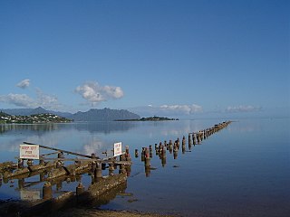
Kāneʻohe Bay, at 45 km2 (17 sq mi), is the largest sheltered body of water in the main Hawaiian Islands. This reef-dominated embayment constitutes a significant scenic and recreational feature along the northeast coast of the Island of Oʻahu. The largest population center on Kāneʻohe Bay is the town of Kāneʻohe.
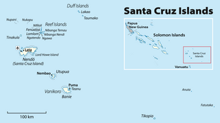
The Santa Cruz Islands form an archipelago in Temotu Province, Solomon Islands. They lie approximately 250 miles to the southeast of the Solomon Islands archipelago, just north of the archipelago of Vanuatu and are considered part of the Vanuatu rain forests ecoregion. The term Santa Cruz Islands is sometimes used to encompass all the islands of Temotu Province, Solomon Islands.

Butaritari is an atoll in the Pacific Ocean island nation of Kiribati. The atoll is roughly four-sided. The south and southeast portion of the atoll comprises a nearly continuous islet. The atoll reef is continuous but almost without islets along the north side. Bikati and Bikatieta islets occupy a corner of the reef at the extreme northwest tip of the atoll. Small islets are found on reef sections between channels on the west side. The lagoon of Butaritari is deep and can accommodate large ships, though the entrance passages are relatively narrow. It is the most fertile of the Gilbert Islands, with relatively good soils and high rainfall. Butaritari atoll has a land area of 13.49 km2 (5.21 sq mi) and a population of 3,224 as of 2015. During World War II, Butaritari was known by United States Armed Forces as Makin Atoll, and was the site of the Battle of Makin. Locally, Makin is the name of a separate but closest atoll, 3 kilometres to the northeast of Butaritari, but close enough to be seen. These two atolls share a dialect of the Gilbertese language.

Virgin Gorda is the third-largest island and second-most populous of the British Virgin Islands (BVI).
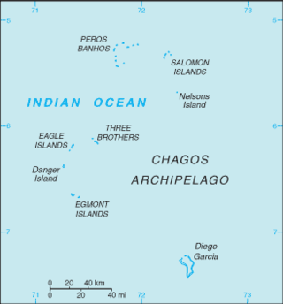
The British Indian Ocean Territory (BIOT) is an archipelago of 55 islands in the Indian Ocean, located south of India. It is situated approximately halfway between Africa and Indonesia. The islands form a semicircular group with an open sea towards the east. The largest, Diego Garcia, is located at the southern extreme end. It measures 60 square kilometres (23 sq mi) and accounts for almost three-quarters of the total land area of the territory. Diego Garcia is the only inhabited island and is home to the joint UK-US naval support facility. Other islands within the archipelago include Danger Island, Three Brothers Islands, Nelson Island, and Peros Banhos, as well as the island groups of the Egmont Islands, Eagle Islands, and the Salomon Islands.

Negril is a small, widely dispersed beach resort and town located in Westmoreland and Hanover parishes at the far western part of Jamaica, 80.8 kilometres (50.2 mi) southwest from Sangster International Airport in Montego Bay.
Cosmoledo Atoll is an atoll of the Aldabra Group and belongs to the Outer Islands of the Seychelles, and is located 1,029 km (639 mi) southwest of the capital, Victoria, on Mahé Island.

The Reef Islands are a loose collection of 16 islands in the in Temotu Province, in the independent nation of Solomon Islands. These islands have historically also been known by the names of Swallow Islands and Matema Islands.

Apo Reef is a coral reef system in the Philippines situated in the western waters of Occidental Mindoro province in the Mindoro Strait. Encompassing 34 square kilometres (13 sq mi), it is considered the world's second-largest contiguous coral reef system, and is the largest in the country. The reef and its surrounding waters are protected areas administered as the Apo Reef Natural Park (ARNP). It is one of the best known and most popular diving regions in the country, and is in the tentative list for UNESCO World Heritage Sites.

Pio Island is an island in Solomon Islands province of Makira-Ulawa. It is situated 4 km north-west of Ugi Island. It is 2.7 km long and 1.5 km wide. The estimated terrain elevation above sea level is some 227 metres. The island has no villages. Coral reef surrounds the island, which is largest in the west and south of the island.
Patteson Shoal is an outer reef in the Reef Islands, in Temotu Province, in the independent nation of Solomon Islands. It is located about 50 km northeast of Nupani. The shoal is named for John Coleridge Patteson.

Uepi is an island in Western Province, in the independent nation of Solomon Islands. It is noted for its high quality blue-water drop-off scuba diving.
Ugi Island, also Uki Island or Uki Ni Massi, is an island 11 km north of the island of Makira, Makira-Ulawa Province in Solomon Islands, Pacific Ocean.
Lomlom is the largest of the Reef Islands in Temotu Province, in the nation of Solomon Islands. It measures seven by four kilometres and separated from Fenualoa by a deep channel. The estimated terrain elevation above sea level is some 21 metres. Variant forms of the island's name are Fonofono and Lom lom.
The Renard Islands are an archipelago in the Solomon Sea. Politically they belong to Milne Bay Province in the southeastern region of Papua New Guinea.

Ravenga is a small island in Torba Province, Vanuatu, in the Pacific Ocean. The island is also known as Ranenger.

The Coral reefs of the Solomon Islands consists of six major islands and over 986 smaller islands, in Oceania, to the east of Papua New Guinea and northwest of Vanuatu. The Solomon Islands lie between latitudes 5° and 13°S, and longitudes 155° and 169°E. The distance between the westernmost and easternmost islands is about 1,500 km (930 mi). The Santa Cruz Islands are situated north of Vanuatu and are especially isolated at more than 200 km (120 mi) from the other islands. The Solomon Islands has the 22nd largest Exclusive Economic Zone of 1,589,477 km2 (613,701 sq mi) of the Pacific Ocean.
 Looking north to Fenualoa from just outside the reef. Tuo village is just visible.
 A canoeist off the west side of Fenualoa at sunset.
 Looking west from the beach on Fenualoa across the Great Reef to the volcano of Tinakula.
 Children on the beach at Tuo village, Fenualoa with a visiting yacht in the background.
 The school at Tuo village, Fenualoa completed in 2008 with New Zealand aid.
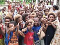 Children at Tuo school at Tuo village, Fenualoa.


