Related Research Articles

Solomon Islands, also known simply as the Solomons, is a country consisting of six major islands and over 900 smaller islands in Melanesia, part of Oceania, to the northeast of Australia. It is directly adjacent to Papua New Guinea to the northwest, Australia to the southwest, New Caledonia and Vanuatu to the southeast, Fiji, Wallis and Futuna, and Tuvalu to the east, and Nauru and the Federated States of Micronesia to the north. It has a total area of 28,896 square kilometres, and a population of 734,887 according to the official estimates for mid 2023. Its capital, Honiara, is located on the largest island, Guadalcanal. The country takes its name from the wider area of the Solomon Islands archipelago, which is a collection of Melanesian islands that also includes the Autonomous Region of Bougainville, but excludes the Santa Cruz Islands.

Auki is the provincial capital of Malaita Province, Solomon Islands. It is situated on the northern end of Langa Langa Lagoon on the north-west coast of Malaita. It is one of the largest provincial towns in Solomon Islands. It was established as the administrative center for Malaita Province in 1909.

Malaita Province is the most populous and one of the largest of the nine provinces of Solomon Islands. It is named after its largest island, Malaita. Other islands include South Malaita Island, Sikaiana Island, and Ontong Java Atoll. Britain defined its area of interest in the Solomons, including Malaita, and central government control of Malaita began in 1893, when Captain Gibson R.N., of HMS Curacoa, declared the southern Solomon Islands as a British Protectorate with the proclamation of the British Solomon Islands Protectorate.
South Malaita Island is the island at the southern tip of the larger island of Malaita in the eastern part of the Solomon Islands. It is also known as Small Malaita and Maramasike for Areare speakers and Malamweimwei for more than 80% of the islanders. The island is referred to as Iola Raha. It is called "small" to distinguish it from the much larger sibling. It is part of Malaita Province. South Malaita came under effective control of the colonial administration after the Solomon Islands was declared a British Protectorate in 1893. During the colonial days, the island was divided by the colonial government and missionary establishments into the Asimeuri, Asimae, and Raroisu'u districts.

Malaita is the primary island of Malaita Province in Solomon Islands. Malaita is the most populous island of the Solomon Islands, with a population of 161,832 as of 2021, or more than a third of the entire national population. It is also the second largest island in the country by area, after Guadalcanal.
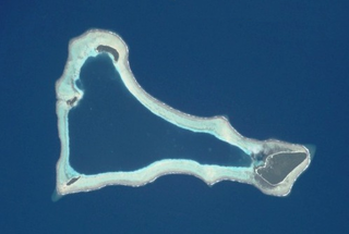
Sikaiana is a small atoll 212 kilometres NE of Malaita in Solomon Islands in the south Pacific Ocean. It is almost 14 kilometres in length and its lagoon, known as Te Moana, is totally enclosed by the coral reef. Its total land surface is only 2 square kilometres. There is no safe anchorage close to this atoll, which makes it often inaccessible to outsiders.
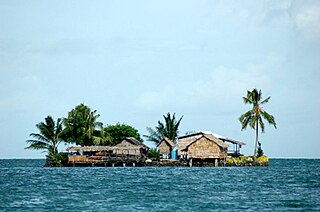
Lau Lagoon is a part of Solomon Islands. It is located on the northeast coast of Malaita Island. The lagoon is more than 35 kilometers long and contains about 60 artificial islands built on the reef.
Funaafou or Funa'afou is an artificial island built on the reef in the Lau Lagoon off the northeast coast of Malaita Island. Administratively, it is in the Malaita Province of the Solomon Islands. Funa'afou island, which is near the edge of the Makwanu Passage, has about 200 inhabitants. It is the first artificial Island built in the Lau lagoon. According to history, the people of Baleo tribe are the first descendants of Funafou Islands

Laulasi island is an artificial island in the Langa Langa Lagoon, South of Auki on the island of Malaita in the Solomon Islands. It is believed that hostilities among the inlanders of Malaita forced some people into the lagoon where over time they built their islands on sandbars after diving for coral. The religion of the island was based on prayers and offerings to the ghosts of dead ancestors, mediated by priests who kept their skulls and relics in tabu houses. Some ancestors were incarnated as sharks which protected their descendants. Langalanga is also the main source of the shell money now made in Solomon Islands.

Langa Langa Lagoon or Akwalaafu is a natural lagoon on the West coast of Malaita near the provincial capital Auki within the Solomon Islands. The lagoon is 21 km in length and just under 1 km wide. The "lagoon people" or "salt water people" live on small artificial islands built up on sand bars over time where they were forced to flee from the headhunters of mainland Malaita.
Tavanipupu is an island in the Solomon Islands. It is located in Marau Sound, at the eastern end of Guadalcanal, between Towara'o Island and Marapa Island, and is part of Guadalcanal Province.
Sulufou is an artificial island built on the reef in the Lau Lagoon on Malaita in the Solomon Islands; it is located in Malaita Province. The road from Auki ends at Fouia wharf opposite the islands of Sulufou and Adaege in the Lau Lagoon.

Severe Tropical Cyclone Namu was considered to be one of the worst tropical cyclones to impact the Solomon Islands on record, after it caused over 100 deaths within the island nations. It was first noted as a weak tropical depression to the north of the Solomon Islands during May 15, 1986. Over the next couple of days, the storm steadily intensified while meandering. After briefly moving west, the storm attained Category 2 intensity on the Australian intensity scale on May 18, as it moved through the island chain on the next day. Cyclone Namu attained peak intensity of 150 km/h (90 mph). After retaining its peak intensity for a day, Namu turned south and weakened steadily. By May 21, the winds of Cyclone Namu had been reduced to only 80 km/h (50 mph). Continuing to weaken, Namu turned east and dissipated on May 22, away from the island chain.
Leonard Alufurai, OBE (1925–2000) was the inaugural Bishop of Malaita.
Dolphins are hunted in Malaita in the Solomon Islands in the South Pacific, mainly for their meat and teeth, and also sometimes for live capture for dolphinariums. Dolphin drive hunting is practised by coastal communities around the world; the animals are herded together with boats and then into a bay or onto a beach. A large-scale example is the Taiji dolphin drive hunt, made famous by the Oscar-winning documentary film The Cove. The hunt on South Malaita Island is smaller in scale. After capture, the meat is shared equally between households. Dolphin teeth are also used in jewelry and as currency on the island.
Malu'u is a village on the north coast of Malaita island in the Solomon Islands. The seat of the sub provincial area, it lies on Suafa Bay, within Malaita Province, along the road between Auki and Lau Lagoon.
John (Jack) Renton (1848–1878), also known as The White Headhunter, was a Scottish seaman from Orkney. In 1868, he was among four or five deserters from the American ship Renard, which specialised in the trade of guano. He and the other deserters travelled in a small boat for 2,000 miles, and eventually landed at Maana'oba (Manaoba), a small island off the north-east coast of Malaita Island in the Solomon Islands. He became a slave of a bigman named Kabbou for 8 years, in which he learnt the Lau language, participated in the island's culture, and became a headhunter. While on Malaita, he befriended a local warrior, Kwaisulia, and taught him English. He is the only European to have been a headhunter and was the first European to live for a long period on Malaita.
Kwaisulia was a prominent tradesman, strongman and blackbirder on the island of Malaita in the late nineteenth century, who for several decades held political control over the north of the island.

The Coral reefs of the Solomon Islands consists of six major islands and over 986 smaller islands, in Oceania, to the east of Papua New Guinea and northwest of Vanuatu. The Solomon Islands lie between latitudes 5° and 13°S, and longitudes 155° and 169°E. The distance between the westernmost and easternmost islands is about 1,500 km (930 mi). The Santa Cruz Islands are situated north of Vanuatu and are especially isolated at more than 200 km (120 mi) from the other islands. The Solomon Islands has the 22nd largest Exclusive Economic Zone of 1,589,477 km2 (613,701 sq mi) of the Pacific Ocean.
Arthur Innes Hopkins was a British Anglican missionary active in the north of the island of Malaita.
References
- ↑ "Historical Photographs of Malaita". University of Queensland. Archived from the original on 22 May 2014. Retrieved 20 May 2014.
- ↑ Stanley, David (1999). South Pacific Handbook. Moon South Pacific. p. 895. ISBN 978-1566911726.
- ↑ Moore, Clive (2017). Making Mala: Malaita in Solomon Islands, 1870s–1930s. ANU Press. p. 128. doi: 10.22459/MM.04.2017 . ISBN 9781760460976.
- ↑ Roger Keesing; James G. Carrier (1992). "Kwaisulia as Culture Hero". History and Tradition in Melanesian Anthropology. University of California Press. p. 176. ISBN 9780520075238 . Retrieved October 14, 2020.
8°26′S160°51′E / 8.433°S 160.850°E
| | This Solomon Islands location article is a stub. You can help Wikipedia by expanding it. |