Related Research Articles
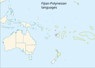
The Polynesian languages form a genealogical group of languages, itself part of the Oceanic branch of the Austronesian family.

Rennell and Bellona is one of the nine provinces of Solomon Islands, comprising two inhabited atolls, Rennell and Bellona, or Mu Ngava and Mu Ngiki respectively in Rennellese, as well as the uninhabited Indispensable Reef. Rennell and Bellona are both Polynesian-inhabited islands within the predominantly Melanesian Solomons. They are thus considered Polynesian outliers. The first known European to sight the islands was Mathew Boyd of Camberwell, London, commander of the merchant ship, Bellona, in 1793. The province has a combined population of 3,041, the least populous province of Solomon Islands. The Samoic language of the islands is, in English texts, called Rennellese. The province's capital is Tigoa, on Rennell Island.

Mangareva is the central and largest island of the Gambier Islands in French Polynesia. It is surrounded by smaller islands: Taravai in the southwest, Aukena and Akamaru in the southeast, and islands in the north. Mangareva has a permanent population of 1,239 (2012) and the largest village on the island, Rikitea, is the chief town of the Gambier Islands.
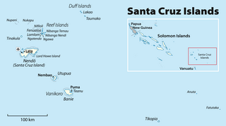
The Duff Islands are a small island group lying to the northeast of the Santa Cruz Islands in province of Temotu Province, in the nation of Solomon Islands. They are also sometimes known as the Wilson Islands.

Taumako is the largest of the Duff Islands, in the nation of Solomon Islands in the Pacific Ocean. This 5.7-kilometre-long (3.5-mile) island has steep sides and rises to a height of 400 metres above sea level. It is composed of basaltic lavas and pyroclastics like the other islands in the Duffs.
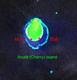
Anuta is a small volcanic island in the province of Temotu in the southeastern part of Solomon Islands. It is one of the smallest permanently inhabited Polynesian islands. It is one of the Polynesian Outlier communities in Melanesia.

The Reef Islands are a loose collection of 16 islands in the in Temotu Province, in the independent nation of Solomon Islands. These islands have historically also been known by the names of Swallow Islands and Matema Islands.

Tikopia is a volcanic island in Temotu Province, in the independent nation of Solomon Islands, southwestern Pacific Ocean. Although most of Solomon Islands is Melanesian, Tikopia is culturally Polynesian. The first Europeans arrived on 22 April 1606 as part of the Spanish expedition of Pedro Fernandes de Queirós.

Temotu is the easternmost province of Solomon Islands. The province was formerly known as Santa Cruz Islands Province. It consists, essentially, of two chains of islands which run parallel to each other from the northwest to the southeast. Its area is 895 square kilometres.

Nukapu is one of the islands of the nation of Solomon Islands. It is in the Reef Islands group in Temotu Province; the easternmost province of the Solomons. The estimated terrain elevation above sea level is 15 metres.

Pio Island is an island in Solomon Islands province of Makira-Ulawa. It is situated 4 km north-west of Ugi Island. It is 2.7 km long and 1.5 km wide. The estimated terrain elevation above sea level is some 227 metres. The island has no villages. Coral reef surrounds the island, which is largest in the west and south of the island.
Nifiloli is an island in the Reef Islands, in Temotu Province, in the independent nation of Solomon Islands. The estimated terrain elevation above sea level is 19 metres. Despite its location in Melanesia, the population of the islands is Polynesian.
Fenualoa is the second largest island in the Reef Islands, in Temotu Province, in the nation of Solomon Islands.
Logha is a small island in the New Georgia Islands group of Western Province, Solomon Islands, located to the east of Ghizo Island. The estimated terrain elevation above sea level is some 28 metres.
Nughu is an island in the Solomon Islands; it is located in Guadalcanal Province. The estimated terrain elevation above sea level is some 12 metres.
Ugi Island, also Uki Island or Uki Ni Massi, is an island 11 km north of the island of Makira, Makira-Ulawa Province in Solomon Islands, Pacific Ocean.
Matema Island or Matema is of one of the Reef Islands in Temotu Province, of the independent nation of Solomon Islands.
Furona Island is a small island off the coast of Santa Isabel in Solomon Islands.

The Bass Islands are a subordinate group in the south of the Duff Islands of the nation of Solomon Islands in the Pacific Ocean. Alternatively they are known as Basses Islands or Ile de Bass. The estimated terrain elevation above sea level is some 15 metres.
Pirumeri Island is an island of the Shortland Islands archipelago, in Western Province, in the independent nation of Solomon Islands. The estimated terrain elevation above sea level is some 25 metres.
References
- ↑ "Tahua". Geoview. Retrieved 30 July 2018.
- ↑ "Tahua". Mapcarta. Retrieved 30 July 2018.
- ↑ "Traveling Luck for Tahua". Traveling Luck. Retrieved 30 July 2018.
- ↑ "Duff Islands - John Seach". Volcano Live. Retrieved 30 July 2018.
- ↑ "Duff Islands". Solomon Islands Historical Encyclopaedia 1893-1978. Retrieved 30 July 2018.