Mbasakana

Last updated
Mbasakana is located off the northwest coast of Malaita Island Malaita Topography.png
Mbasakana is located off the northwest coast of Malaita Island

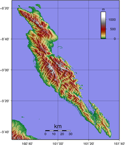
Mbasakana is an island in Malaita Province, Solomon Islands. [1] [2]

Related Research Articles

USS <i>Greenling</i> (SS-213) United States Navy Gato-class submarine

USS Greenling (SS-213), a Gato-class submarine, was the first ship of the United States Navy to be named for the greenling.

<span class="mw-page-title-main">Malaita Province</span> Province of Solomon Islands

Malaita Province is the most populous and one of the largest of the nine provinces of Solomon Islands. The population of the province is 122,620 (1999). The area of the province is 4,225 km2 (1,631 sq mi).

<span class="mw-page-title-main">Guadalcanal Province</span> Province in Honiara, Solomon Islands

Guadalcanal Province is one of the nine provinces of Solomon Islands, consisting of the island of Guadalcanal. It is a 2,510 square mile (5,336 km2) island and is largely a jungle. Its name was given by Pedro de Ortega Valencia, born in the village of Guadalcanal, Seville, Spain. The national capital and largest city of the Solomon Islands, Honiara, is on the island; in July 1983, it was designated a 22 km2 (8.5 sq mi) separately-administered Capital Territory and is no longer considered part of the province. The population of the province is 93,613 (2009), not including the capital territory. The population of the island is 161,197. Honiara serves as the provincial capital. The climate is rainforest tropical. The estimated terrain elevation above sea level is 447 meters (1,467 ft).

<span class="mw-page-title-main">Indispensable Reefs</span> Three atolls in Rennell and Bellona Province, Solomon Islands

The Indispensable Reefs are a chain of three large coral atolls in the Coral Sea. They are located about 50 km (30 mi) south of Rennell Island. The chain stretches over a length of 114 km (71 mi) and its average width is 18 km (11 mi).

Funaafou or Funa'afou is an artificial island built on the reef in the Lau Lagoon off the northeast coast of Malaita Island. Administratively, it is in the Malaita Province of Solomon Islands. Funa'afou island, which is near the edge of the Makwanu Passage, has about 200 inhabitants. It is the first artificial Island built in the Lau lagoon. According to history, the people of Baleo tribe are the first descendants of Funafou Islands

Nughu is an island in the Solomon Islands; it is located in Guadalcanal Province. The estimated terrain elevation above sea level is some 12 metres.

Tavanipupu is an island in the Solomon Islands. It is located in Marau Sound, at the eastern end of Guadalcanal, between Towara'o Island and Marapa Island, and is part of Guadalcanal Province.

Vulelua is an island in Solomon Islands; it is located in Guadalcanal Province. There is a hotel in the island.

<span class="mw-page-title-main">Ugi Island</span>

Ugi Island, also Uki Island or Uki Ni Massi, is an island 11 km north of the island of Makira, Makira-Ulawa Province in Solomon Islands, Pacific Ocean.

Adagege, alternatively spelled Ada Gege or Ada-gege, is an artificial island built on the reef in the Lau Lagoon on Malaita in Solomon Islands; it is located in Malaita Province. The road from Auki ends at Fouia wharf opposite the islands of Sulufou and Adaege in the Lau Lagoon.

Alite Island is an island in Malaita Province, Solomon Islands. It is located off the west coast of Malaita Island. The estimated terrain elevation above sea level is 6 metres.

<span class="mw-page-title-main">Maana'omba</span> Island in Solomon Islands

Maana'omba is an island in Malaita Province, in Solomon Islands.

<span class="mw-page-title-main">Ndai</span>

Ndai, formerly known as Gower Island, is an island in Malaita Province, Solomon Islands. It is located to the north of Malaita Island.

Sulufou is an artificial island built on the reef in the Lau Lagoon on Malaita, Malaita Province in the nation of Solomon Islands. The road from Auki ends at Fouia wharf opposite the islands of Sulufou and Adaege in the Lau Lagoon.

USS LST-342 was an LST-1-class tank landing ship built for the United States Navy during World War II. LST-342 was laid down on 21 August 1942 by the Norfolk Navy Yard; launched on 8 November 1942; sponsored by Mrs. Philip H. Ryan; and commissioned on 31 December 1942.

Furona Island is a small island off the coast of Santa Isabel in Solomon Islands.

<span class="mw-page-title-main">2018–19 South Pacific cyclone season</span> Tropical cyclone season

The 2018–19 South Pacific cyclone season was a below-average season that produced 5 tropical cyclones, 2 of which became severe tropical cyclones. The season officially runs from November 1, 2018, to April 30, 2019; however, a tropical cyclone could have formed at any time between July 1, 2018, and June 30, 2019, and would count towards the season total. During the season, tropical cyclones were officially monitored by the Fiji Meteorological Service, Australian Bureau of Meteorology, and New Zealand's MetService. The United States Armed Forces through the Joint Typhoon Warning Center (JTWC) also monitored the basin and issued warnings for American interests. RSMC Nadi attaches a number and an F suffix to tropical disturbances that form in or move into the basin, while the JTWC designates significant tropical cyclones with a number and a P suffix. The FMS, the BoM and MetService all use the Australian Tropical Cyclone Intensity Scale and estimate wind speeds over a period of ten minutes, while the JTWC estimates sustained winds over a 1-minute period, which are subsequently compared to the Saffir–Simpson hurricane wind scale (SSHWS).

<span class="mw-page-title-main">Chinatown, Honiara</span> Suburb in Guadalcanal, Honiara Town, Solomon Islands

Chinatown is a suburb of Honiara, Solomon Islands, located southeast of the main center.

Tahua is one of the Duff Islands, of Temotu Province, in the independent nation of Solomon Islands. The estimated terrain elevation above sea level is some 23 metres. The island is inhabited.

References

  1. "Solomon Islands: Mbasakana". Latitude. Retrieved 26 July 2018.
  2. "Satellite map of Mbasakana and its surroundings". Traveling Luck. Retrieved 26 July 2018.

8°18′40″S160°34′55″E / 8.311°S 160.582°E / -8.311; 160.582