Early history
Ballale means border place in the local Alu language. As long as the natives of the Shortland Islands can remember, the island was uninhabited. According to a local legend, a strange blue light was often observed over the island. Therefore, the island was avoided, and, traditionally, no one lived there. For the local people, Ballale Island was considered a haunted place (sacu-sacu). War groups from neighbouring Buka Island used this uninhabited island to cannibalize their prisoners captured during successful tribal feuds and headhunting raids to Choiseul Island. [2]
Englishman Sam Atkinson purchased the island in 1901 and established a coconut plantation, harvesting copra. The plantation included the Atkinson family home, as well as copra drying sheds and living quarters for workers. Copra was exported by boat. When Sam Atkinson died in 1931, his wife Edith kept on managing the plantation. She remained on the island until early 1942 when the British colonial government ordered all Europeans to be evacuated from the Solomons Islands.

Guadalcanal is the principal island in Guadalcanal Province of Solomon Islands, located in the southwestern Pacific Ocean, northeast of Australia. It is the largest island in the Solomons by area and the second-largest by population. The island is mainly covered in dense tropical rainforest and has a mountainous hinterland.

Tabuaeran, also known as Fanning Island, is an atoll that is part of the Line Islands of the central Pacific Ocean and part of the island nation of Kiribati. The land area is 33.73 square kilometres, and the population in 2015 was 2,315. The maximum elevation is about 3 m (10 ft) above high tide.
Kavieng is the capital of the Papua New Guinean province of New Ireland and the largest town on the island of the same name. The town is located at Balgai Bay, on the northern tip of the island. As of 2009, it had a population of 17,248.

USS Montpelier (CL-57) was one of 27 United States Navy Cleveland-class light cruisers completed during or shortly after World War II. She was the second US Navy ship to be named for the city of Montpelier, Vermont. Montpelier was commissioned in September 1942 and saw service in several campaigns in the Pacific. Like almost all her sister ships, she was decommissioned shortly after the end of the war, and never saw active service again. Montpelier was scrapped in the early 1960s.

The Battle of Rabaul, also known by the Japanese as Operation R, an instigating action of the New Guinea campaign, was fought on the island of New Britain in the Australian Territory of New Guinea, from 23 January into February 1942. It was a strategically significant defeat of Allied forces by Japan in the Pacific campaign of World War II, with the Japanese invasion force quickly overwhelming the small Australian garrison, the majority of which was either killed or captured. Hostilities on the neighbouring island of New Ireland are usually considered to be part of the same battle. Rabaul was significant because of its proximity to the Japanese territory of the Caroline Islands, site of a major Imperial Japanese Navy base on Truk.

The Russell Islands are two small islands, as well as several islets, of volcanic origin, in the Central Province of Solomon Islands. They are located approximately 48 kilometres northwest of Guadalcanal. The islands are partially covered in coconut plantations, and have a copra and oil factory at Yandina. Yandina also has basic services, including a store, post office, and airport.

Vella Lavella is an island in Western Province, in the independent nation of Solomon Islands. It lies to the west of New Georgia, but is considered one of the New Georgia Group. To its west are the Treasury Islands.

The Bougainville campaign was a series of land and naval battles of the Pacific campaign of World War II between Allied forces and the Empire of Japan, named after the island of Bougainville. It was part of Operation Cartwheel, the Allied grand strategy in the South Pacific.
The Shortland Islands is an archipelago of Western Province, Solomon Islands, at 6.92°S 155.88°E. The island group lies in the extreme north-west of the country's territory, close to the south-east edge of Bougainville Island, Papua New Guinea.
Treasury Islands are a small group of islands a few kilometres to the south of Bougainville and 24 kilometres from the Shortland Islands. They form part of the Western Province of the country of Solomon Islands. The two largest islands in the Treasuries are Mono Island and the smaller Stirling Island. The deep water strait between these two islands is called Blanche Harbour.

The British Solomon Islands Protectorate was first declared over the southern Solomon Islands in June 1893, when Captain Herbert Gibson of HMS Curacoa, declared the southern islands a British protectorate.

Fauro Island is an island of the Shortland Islands archipelago, located in the Western Province of Solomon Islands, located at 6°55′S156°4′E. Along the center spine of the island are Mount Pauboleala with an elevation of 574 metres, Mount Lalauka with an elevation of 517 m, and Sharp Peak with an elevation of 484 m.
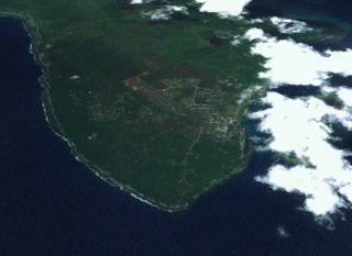
Balalae Airport is a small civil airport on Balalae island operated by Solomon Airlines. It is located in the northwest of the Solomon Islands, part of the Shortland Island Group and south of Bougainville Island. It serves the nearby Shortland Islands and Fauro Island. It's a 1.75 km long sandy coral airstrip only 5 feet above sea level with a small customs area. It was built by prisoners of war, mostly British captured during the siege of Singapore, under the command of the Japanese during their occupation of the Solomons to protect the stronghold of Rabaul. In about June 1943, all Allied prisoners remaining on the island were killed and buried in mass graves. 436 bodies of unidentified soldiers were exhumed post-war. During 1943, Admiral Yamamoto planned to arrive on the airport from Rabaul to increase morale after the defeat at the Battle of Guadalcanal. He was shot down while passing Bougainville Island during Operation Vengeance, during the Guadalcanal campaign.

The Landings at Cape Torokina, also known as Operation Cherryblossom, took place at the beginning of the Bougainville campaign in World War II. The amphibious landings were carried out by elements of the United States Marine Corps in November 1943 on Bougainville Island in the South Pacific, as part of Allied efforts to advance towards the main Japanese base around Rabaul under Operation Cartwheel. Coming in the wake of Allied successes at Guadalcanal and in the central Solomons, the landings were intended to secure a beachhead with the purpose of establishing several bases from which to project air and naval power closer towards Rabaul, in an effort to neutralize the large Japanese force that had been established there.

Buin is a town on Bougainville Island, and the capital of the South Bougainville District, in the Autonomous Region of Bougainville, in eastern Papua New Guinea. The island is in the northern Solomon Islands Archipelago of the Melanesia region, in the South Pacific Ocean.
Faisi is a small island in the Western Province of Solomon Islands. The island is a part of Shortland Islands archipelago.
Norman Henry Bowell was an English first-class cricketer and British Army soldier.
This is a list of Imperial Japanese Navy bases and facilities

Operation I-Go was an aerial counter-offensive launched by Imperial Japanese forces against Allied forces during the Solomon Islands and New Guinea campaigns in the Pacific Theater of World War II. Taking place from 1–16 April 1943, Japanese aircraft—primarily from Imperial Japanese Navy units under the command of Admirals Isoroku Yamamoto and Jinichi Kusaka—attacked Allied ships, aircraft, and land installations in the southeast Solomon Islands and New Guinea. The goal of the operation was to halt the Allied offensives to give Japan time to prepare a new set of defenses in response to recent defeats in the Guadalcanal campaign and in New Guinea at Buna–Gona, Wau, and the Bismarck Sea.
The Balalae Island mass graves was a war crime committed by the Imperial Japanese Army during World War II against British prisoners of war. The mass graves were discovered by Australian investigators after the end of the war.

