
The Aegean Sea is an elongated embayment of the Mediterranean Sea located between the Greek and Anatolian peninsulas. The sea has an area of some 215,000 square kilometres. In the north, the Aegean is connected to the Marmara Sea and the Black Sea by the straits of the Dardanelles and Bosphorus. The Aegean Islands are located within the sea and some bound it on its southern periphery, including Crete and Rhodes. The sea reaches a maximum depth of 3,544 meters, to the east of Crete.

The Canary Islands, also known informally as the Canaries, are a Spanish archipelago and the southernmost autonomous community of Spain located in the Atlantic Ocean, in a region known as Macaronesia, 100 kilometres west of Morocco at the closest point. It is one of eight regions with special consideration of historical nationality as recognized by the Spanish government. Canary Islands are geographically located in the African Tectonic Plate, even though the archipielago is economically and politically European, as it is part of the European Union.
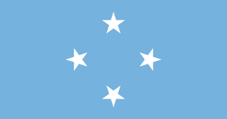
The Federated States of Micronesia is an independent republic associated with the United States. It consists of four states – from west to east, Yap, Chuuk, Pohnpei and Kosrae – that are spread across the Western Pacific Ocean. Together, the states comprise around 607 islands that cover a longitudinal distance of almost 2,700 km (1,678 mi) just north of the equator. They lie northeast of New Guinea, south of Guam and the Marianas, west of Nauru and the Marshall Islands, east of Palau and the Philippines, about 2,900 km (1,802 mi) north of eastern Australia, 3,400 km southeast of Japan, and some 4,000 km (2,485 mi) southwest of the main islands of Hawaii.

Honolulu is the capital and largest city of the U.S. state of Hawaii. It is an unincorporated part of and the county seat of the City and County of Honolulu along the southeast coast of the island of Oʻahu. The city is the main gateway to Hawaiʻi and a major portal into the United States. The city is also a major hub for international business and military defense, as well as being host to a diverse variety of east–west and Pacific cultures, cuisine, and traditions.

Nassau is the capital and largest city of The Bahamas. With a population of 274,400 as of 2016, or just over 70% of the entire population of the Bahamas (≈391,000), Nassau is commonly defined as a primate city, dwarfing all other towns in the country. It is the centre of commerce, education, law, administration and media of the country.

Rhode Island, officially the State of Rhode Island and Providence Plantations, is a state in the New England region of the United States. It is the smallest U.S. state by area and the seventh least populous, but it is also the second most densely populated. Rhode Island is bordered by Connecticut to the west, Massachusetts to the north and east, and the Atlantic Ocean to the south via Rhode Island Sound and Block Island Sound. It also shares a small maritime border with New York. Providence is the state capital and most populous city in Rhode Island.

The Virgin Islands are an archipelago in the Caribbean Sea. They are geologically and biogeographically the easternmost part of the Greater Antilles, the northern islands belonging to the Puerto Rico Trench and St. Croix being a displaced part of the same geologic structure. Politically, the British Virgin Islands have been governed as the western island group of the Leeward Islands, which are the northern part of the Lesser Antilles, and form the border between the Caribbean Sea and the Atlantic Ocean. The archipelago is separated from the true Lesser Antilles by the Anegada Passage and from the main island of Puerto Rico by the Virgin Passage.

Malé is the capital and most populous city in the Republic of Maldives. With a population of 133,412 and an area of 9.27 square kilometres (3.58 sq mi), it is also one of the most densely populated cities in the world. The city is geographically located at the southern edge of North Malé Atoll. Administratively, the city consists of a central island, an airport island, and two other islands governed by the Malé City Council.

Honshu is the largest and most populous main island of Japan. It is located south of Hokkaido across the Tsugaru Strait, north of Shikoku across the Inland Sea, and northeast of Kyushu across the Kanmon Straits. The island separates the Sea of Japan, which lies to its north and west, from the North Pacific Ocean to the south and east. It is the 7th largest island in the world, and the 2nd most populous after the Indonesian island of Java.

The Western Hemisphere is a geographical term for the half of Earth which lies west of the prime meridian and east of the antimeridian. The other half is called the Eastern Hemisphere.
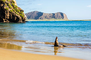
The Galápagos Islands, part of the Republic of Ecuador, are an archipelago of volcanic islands distributed on either side of the equator in the Pacific Ocean surrounding the centre of the Western Hemisphere, 906 km (563 mi) west of continental Ecuador. The islands are known for their large number of endemic species and were studied by Charles Darwin during the second voyage of HMS Beagle. His observations and collections contributed to the inception of Darwin's theory of evolution by means of natural selection.

A capital or capital city is the municipality exercising primary status in a country, state, province, or other administrative region, usually as its seat of government. A capital is typically a city that physically encompasses the government's offices and meeting places; the status as capital is often designated by its law or constitution. In some jurisdictions, including several countries, the different branches of government are located in different settlements. In some cases, a distinction is made between the official (constitutional) capital and the seat of government, which is in another place.

North Sumatra is a province of Indonesia. It consists of a large northwestern belt of the island of Sumatra and its capital is Medan. North Sumatra is the fourth most-populous province after West Java, East Java and Central Java — it covers an area of 72,981 sq.km, and at the Census of 2015 it had a population of 13,923,262; the latest official estimate as at mid 2019 is 14,639,400.

UTC−05:00 is an identifier for a time offset from UTC of −05:00. In North America, it is observed in the Eastern Time Zone during standard time, and in the Central Time Zone during the other eight months. The western Caribbean uses it year round.
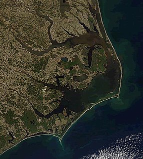
The Outer Banks are a 200-mile-long (320 km) string of barrier islands and spits off the coast of North Carolina and southeastern Virginia, on the east coast of the United States. They cover most of the North Carolina coastline, separating Currituck Sound, Albemarle Sound, and Pamlico Sound from the Atlantic Ocean.

The West Indies is a region of the North Atlantic Ocean and the Caribbean that includes the island countries and surrounding waters of three major archipelagos: the Greater Antilles, the Lesser Antilles, and the Lucayan Archipelago.
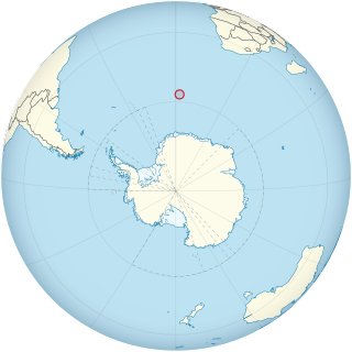
Bouvet Island is an uninhabited subantarctic high island and dependency of Norway located in the South Atlantic Ocean at 54°25′S3°22′E, thus locating it north of and outside the Antarctic Treaty System. It lies at the southern end of the Mid-Atlantic Ridge and is the most remote island in the world, approximately 1,700 kilometres (1,100 mi) north of the Princess Astrid Coast of Queen Maud Land, Antarctica, 1,900 kilometres (1,200 mi) east of the South Sandwich Islands, 1,600 kilometres (990 mi) south of Gough Island, and 2,600 kilometres (1,600 mi) south-southwest of the coast of South Africa.

The Caribbean Netherlands are the three special municipalities of the Netherlands that are located in the Caribbean Sea. They consist of the islands of Bonaire, Sint Eustatius and Saba, although the term "Caribbean Netherlands" is sometimes used to refer to all of the islands in the Dutch Caribbean. In legislation, the three islands are also known as the BES Islands. The islands are currently classified as public bodies in the Netherlands and as overseas countries and territories of the European Union; thus, EU law does not automatically apply.

The Dutch Caribbean are the territories, colonies, and countries, both former and current, of the Dutch Empire and the Kingdom of the Netherlands that are located in the Lesser Antilles archipelago of the Caribbean Sea.
