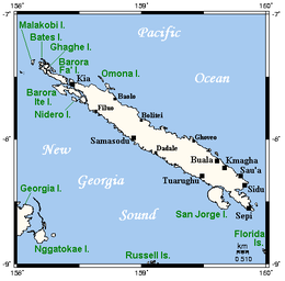
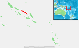
Santa Isabel Island (also known as Isabel, Ysabel and Mahaga) is the longest in Solomon Islands, the third largest in terms of surface area, and the largest in the group of islands in Isabel Province.
The highest point in Santa Isabel is Mount Sasari, 1,220 metres (4,000ft). The Marutho river runs down Mount Sasari to the ocean at Hofi. Almost all the rivers or streams run from that centre point except for those at the other tip of the island on the Katova side.
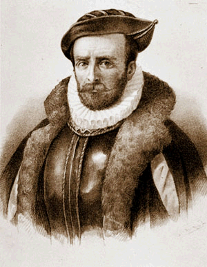
The first European landing in the Solomon Islands archipelago was made at Santa Isabel Island, by the Spanish explorer Álvaro de Mendaña on 7 February 1568. It was charted as Santa Isabel de la Estrella (Spanish for "St. Elizabeth of the Star"). A settlement was established by the Spaniards, and a small boat (known in the accounts as "the brigantine") was built to survey and chart the surrounding sea and islands. These local explorations led by maestre de campoPedro Ortega Valencia and AlférezHernando Enríquez resulted in the discoveries of the islands of Malaita, Guadalcanal, Savo, Vangunu, Choiseul, Makira, Ulawa, Malaupaina, Malaulalo, Ali'ite, and Ugi Island.[2][3] The Spanish immediately came into contact with Solomon Islanders and at first the relationship was cordial. However, the Spanish expedition's need for fresh food and water quickly led to tension and conflict, the Solomon Islanders’ subsistence economy being unable to provide continuous supplies to the Spanish.[4]
Having found no gold and little food, and beset by attacks and sickness, the Spanish colonists shifted their colony to the site of today's Honiara on Guadalcanal, and the settlement on Santa Isabel was abandoned.
Santa Isabel islanders suffered attacks from blackbirding in the nineteenth century (the often brutal recruitment or kidnapping of labourers for the sugar plantations in Queensland and Fiji).
In April 1885 a German Protectorate was declared over the North Solomon Islands, including Santa Isabel Island. In 1900, under the terms of Treaty of Berlin, signed on 14 November 1899, Germany transferred the North Solomon Islands (except for Bougainville and its surrounding islands) to the British Solomon Islands Protectorate in exchange for the British giving up all claims to Samoa. Missionaries settled on Santa Isabel Island under both protectorates, converting most of the population to Christianity. In the early 20th century several British and Australian firms began large-scale coconut planting.
U.S. Navy Douglas SBD-3 Dauntless dive bombers of scouting squadron VS-6 en route to attack the Japanese seaplane base at Rekata Bay, Santa Isabel Island, August–September 1942. VS-6 operated from the aircraft carrier USS Enterprise (CV-6) in the Solomons until she had to return to Pearl Harbor, Hawaii (US), after the Battle of the Eastern Solomons on 24–25 August 1942. VS-6 (and VB-6 crews) under CO Turner Cladwell then operated for another month from Henderson Field, Guadalcanal, known as "Flight 300" (from the Enterprise flight schedule on 24 August).
During World War II, the Imperial Japanese Navy established a seaplane base at Rekata Bay on the northeast coast. The base was bombed by American forces from August 1942 to August 1943. In the following month, the Japanese evacuated the base. Large bomb craters can still be seen near the former Japanese base.
Since the independence of Solomon Islands in July 1978, Santa Isabel Island has been administered as part of Isabel Province.
On 27 May, 2011, seventeen men were arrested for burning down the houses in Ulubea riverside settlement, 33 houses in all, as a result of a property dispute.[5][6] The number was later expanded to 31.[7]
Languages
The population of Santa Isabel speak as many as eight languages in addition to English and Solomon Islands Pijin.
Geoffrey M. White, Identity through History; Living Stories in a Solomon Islands Society, Cambridge Studies in Social and Cultural Anthropology Series (No. 83) ISBN978-0-521-40172-2
Solomon Islands is a sovereign state in the Melanesia subregion of Oceania in the western Pacific Ocean. This page is about the history of the nation state rather than the broader geographical area of the Solomon Islands archipelago, which covers both Solomon Islands and Bougainville Island, a province of Papua New Guinea. For the history of the archipelago not covered here refer to the former administration of the British Solomon Islands Protectorate, the North Solomon Islands and the History of Bougainville.
Solomon Islands is an island country in the South Pacific Ocean, that lies east of Papua New Guinea.
Guadalcanal is the principal island in Guadalcanal Province of the Solomon Islands, located in the southwestern Pacific Ocean, northeast of Australia. It is the largest island in the Solomons by area and the second-largest by population. The island is mainly covered in dense tropical rainforest and has a mountainous hinterland.
Solomon Islands is a country consisting of six major islands and over 900 smaller islands in Melanesia, part of Oceania, to the northeast of Australia. It is directly adjacent to Papua New Guinea to the northwest, Australia to the southwest, New Caledonia and Vanuatu to the southeast, Fiji, Wallis and Futuna and Tuvalu to the east, Nauru and the Federated States of Micronesia to the north. It has a land area of 29,000 square kilometres (11,000 sq mi), and a population of approximately 700,000. Its capital, Honiara, is located on the largest island, Guadalcanal. The country takes its name from the wider area of the Solomon Islands (archipelago), which is a collection of Melanesian islands that also includes the Autonomous Region of Bougainville, but excludes the Santa Cruz Islands.
Álvaro de Mendaña y Neira was a Spanish navigator, explorer, and cartographer, best known for two of the earliest recorded expeditions across the Pacific Ocean in 1567 and 1595. His voyages led to the discovery of the Marquesas, Cook Islands, and Solomons among other archipelagos. Born in Congosto, in El Bierzo Region (León), he was the nephew of Lope García de Castro, viceroy of Peru.
Solomon Islands is divided into nine provinces. The national capital, Honiara, on the island of Guadalcanal, is separately governed as the country's Capital Territory.
The family of Southeast Solomonic languages forms a branch of the Oceanic languages. It consists of some 26 languages covering the South East Solomon Islands, from the tip of Santa Isabel to Makira. The fact that there is little diversity amongst these languages, compared to groups of similar size in Melanesia, suggests that they dispersed in the relatively recent past. Bugotu and Gela are two of the most conservative languages.
Vella Lavella is an island in the Western Province of the Solomon Islands. It lies to the west of New Georgia, but is considered one of the New Georgia Group. To its west are the Treasury Islands.
Malaita is the primary island of Malaita Province in Solomon Islands. Malaita is the most populous island of the Solomon Islands, with a population of 161,832 as of 2021, or more than a third of the entire national population. It is also the second largest island in the country by area, after Guadalcanal.
Choiseul Island, native name Lauru, is the largest island of the Choiseul Province, Solomon Islands, at 7.08°S 157°E. The administrative headquarters of Choiseul Province is situated in the town of Taro, on Taro Island.
The following outline is provided as an overview of and topical guide to Solomon Islands:
Langa Langa Lagoon or Akwalaafu is a natural lagoon on the West coast of Malaita near the provincial capital Auki within the Solomon Islands. The lagoon is 21 km in length and just under 1 km wide. The "lagoon people" or "salt water people" live on small artificial islands built up on sand bars over time where they were forced to flee from the headhunters of mainland Malaita.
Solomon Islands–Spain relations are the bilateral and diplomatic relations between these two countries. Solomon Islands does not have an embassy resident in Spain but maintains an honorary consulate in Madrid.
The Coral reefs of the Solomon Islands consists of six major islands and over 986 smaller islands, in Oceania, to the east of Papua New Guinea and northwest of Vanuatu. The Solomon Islands lie between latitudes 5° and 13°S, and longitudes 155° and 169°E. The distance between the westernmost and easternmost islands is about 1,500 km (930 mi). The Santa Cruz Islands are situated north of Vanuatu and are especially isolated at more than 200 km (120 mi) from the other islands. The Solomon Islands has the 22nd largest Exclusive Economic Zone of 1,589,477 km2 (613,701 sq mi) of the Pacific Ocean.
This page is based on this Wikipedia article Text is available under the CC BY-SA 4.0 license; additional terms may apply. Images, videos and audio are available under their respective licenses.