Related Research Articles

Solomon Islands is a nation in the South Pacific Ocean, that lies east of Papua New Guinea.

Solomon Islands is a sovereign country consisting of six major islands and over 900 smaller islands in Oceania, to the east of Papua New Guinea and northwest of Vanuatu. It has a land area of 28,400 square kilometres (11,000 sq mi), and a population of 652,858. Its capital, Honiara, is located on the largest island, Guadalcanal. The country takes its name from the Solomon Islands archipelago, which is a collection of Melanesian islands that also includes the North Solomon Islands, but excludes outlying islands, such as the Santa Cruz Islands and Rennell and Bellona.
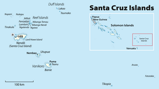
The Santa Cruz Islands are a group of islands in the Pacific Ocean, part of Temotu Province of the nation of Solomon Islands. They lie approximately 250 miles (400 km) to the southeast of the Solomon Islands archipelago. The Santa Cruz Islands lie just north of the archipelago of Vanuatu, and are considered part of the Vanuatu rain forests ecoregion.

Pacific Ocean Areas was a major Allied military command in the Pacific Ocean theater of World War II. It was one of four major Allied commands during the Pacific War, and one of three United States commands in the Asiatic-Pacific Theater. Admiral Chester W. Nimitz of the U.S. Navy, Commander in Chief, U.S. Pacific Fleet, headed the command throughout its existence.

The Russell Islands are two small islands, as well as several islets, of volcanic origin, in the Central Province of Solomon Islands. They are located approximately 48 kilometres northwest of Guadalcanal. The islands are partially covered in coconut plantations, and have a copra and oil factory at Yandina. Yandina also has basic services, including a store, post office, and airport.

Isabel Province is one of the provinces of Solomon Islands. The province had a population of around 35,257 as of 2020, mostly concentrated on the main island, Santa Isabel Island. The capital of the province is Buala on Santa Isabel Island, which has scheduled airline services to Honiara on Solomon Airlines from Fera Airport, on Fera Island, a 15-minute boat ride from Buala.

The British Solomon Islands Protectorate was first declared over the southern Solomons in 1893, when Captain Gibson, R.N., of HMS Curacoa, declared the southern islands a British protectorate. Other islands were subsequently declared to form part of the Protectorate.

Santa Isabel Island is the longest in Solomon Islands, the third largest in terms of surface area, and the largest in the group of islands in Isabel Province.
Buala is a town in Solomon Islands located on Santa Isabel Island, which is the longest island in Solomon Islands. Buala consists of Jejevo station and Buala Village. Buala is located on a side of a hill so there is no place for the town to expand, new feeder roads have been continuously developed to the east and western ends of the township. One of these roads reached as far as Hovokiolo village in the west Maringe district. Kubolota, Tithiro, and Maglau are villages close to this small town. Higher up inland, are Tirotogna, Bara, Gurena and Kolokofa. People from these villages also frequent Buala town.
Fera Airport is an airport on Fera Island in the Solomon Islands. The airport is a roughly 3,000 foot long grass strip, and there are no roads to and from the terminal block, which was completed in April 2012. It is a 15-minute boat ride to Buala on Santa Isabel Island. Solomon Airlines flies to Fera three times weekly from Honiara.
Suavanao Airport is an airport on Santa Isabel Island in the Solomon Islands.
Fera may refer to:
San Jorge Island is the second largest island in the Isabel Province, Solomon Islands.

The Solomon Islands is an archipelago in the western South Pacific Ocean, located northeast of Australia. The archipelago is in the Melanesia subregion and bioregion of Oceania. It forms the eastern boundary of the Solomon Sea. The archipelago forms much of the territory of Solomon Islands. The main islands are Choiseul, the Shortland Islands, the New Georgia Islands, Santa Isabel, the Russell Islands, the Florida Islands, Tulagi, Malaita, Maramasike, Ulawa, Owaraha, Makira, and Guadalcanal. The largest island, Bougainville Island, is geographically part of the Solomon Islands (archipelago), while politically an autonomous region of Papua New Guinea. The nation state of Solomon Islands covers a subset of the Solomon Islands archipelago and includes isolated low-lying coral atolls and high islands including Sikaiana, Rennell Island, Bellona Island, and the Santa Cruz Islands.
Thousand Ships Bay is a bay located on the south coast of Santa Isabel Island in the Solomon Islands, between San Jorge Island and Santa Isabel Island.
Furona Island is a small island off the coast of Santa Isabel Island in the Solomon Islands.

Kamaosi Village is a small village in the south eastern end of Santa Isabel Island, Isabel Province, Solomon Islands. It is close to Gululu. It contains one of the two high schools on the island, Sir Dudley Tuti College.
The Diocese of Ysabel is one of the nine current dioceses of the Anglican Church of Melanesia.
Mahige is a small islet in Isabel Province of the Solomon Islands. The islet is located off the south-east tip of Santa Isabel Island.

The Coral reefs of the Solomon Islands consists of six major islands and over 986 smaller islands, in Oceania, to the east of Papua New Guinea and northwest of Vanuatu. The Solomon Islands lie between latitudes 5° and 13°S, and longitudes 155° and 169°E. The distance between the westernmost and easternmost islands is about 1,500 km (930 mi). The Santa Cruz Islands are situated north of Vanuatu and are especially isolated at more than 200 km (120 mi) from the other islands. The Solomon Islands has the 22nd largest Exclusive Economic Zone of 1,589,477 km2 (613,701 sq mi) of the Pacific Ocean.
References
- ↑ Brewer, Tom David (2013). Social determinants of the exploitation and management of coral reef resources in Solomon Islands (phd thesis). James Cook University.
- ↑ Kratter, Andrew W.; Steadman, David W.; Smith, Catherine E.; Filardi, Christopher E.; Webb, Horace P. (2001). "Avifauna of a Lowland Forest Site on Isabel, Solomon Islands". The Auk. 118 (2): 472–483. doi:10.2307/4089807. ISSN 0004-8038.
- ↑ "MP Welcomes New Fera Airport Terminal - Solomon Times Online". SolomonTimes.com. Retrieved 2022-06-24.
Coordinates: 8°06′26″S159°35′42″E / 8.1072°S 159.595°E
| | This Solomon Islands location article is a stub. You can help Wikipedia by expanding it. |