
The Reef Islands are a loose collection of 16 islands in the in Temotu Province, in the independent nation of Solomon Islands. These islands have historically also been known by the names of Swallow Islands and Matema Islands.
The Reef Islands are a loose collection of 16 islands in the in Temotu Province, in the independent nation of Solomon Islands. These islands have historically also been known by the names of Swallow Islands and Matema Islands.
The islands lie about 80 km (50 mi) north of Nendo, the largest of the Santa Cruz Islands. The center of the group is at approximately 10°12'36" S lat., 166°10'12" E. long. The islands are raised some five metres on the east and tilted west. [1] The islands are subject to tidal surges caused by cyclones and volcanic activity from nearby Tinakula volcano. The island soils are shallow yet fertile. [2]

The islands or atolls of the group are:
Numa Miombilou or "Great Reef" is one continuous shoal, extending about 25 km (16 mi) west of Nifiloli. About 10 km (6.2 mi) to the south of this shoal are 4 small coral reefs:
Separated from these groups are what are called the "outer islands":
The total population of the Reef Islands is about 5,600, according to 2003 estimates. This includes a Polynesian community, believed to be descendants of people from northern Tuvalu.
Two very different languages are spoken in the Reef Islands, both Oceanic, yet genealogically and typologically very different. The inhabitants of Pileni, Matema, Nupani and Nukapu, speak Vaeakau-Taumako (a.k.a. Pileni), a Polynesian outlier language. The remaining Melanesian (non-Polynesian) population speaks Äiwoo, a member of the Reefs–Santa Cruz group of Oceanic. [3]

Solomon Islands is an island country in the South Pacific Ocean, that lies east of Papua New Guinea.
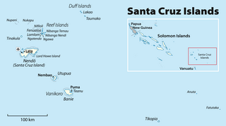
The Santa Cruz Islands are a group of islands in the Pacific Ocean, part of Temotu Province of the nation of Solomon Islands. They lie approximately 250 miles to the southeast of the Solomon Islands archipelago. The Santa Cruz Islands lie just north of the archipelago of Vanuatu, and are considered part of the Vanuatu rain forests ecoregion.
Fatutaka, Fatu Taka or Patu Taka is a small volcanic island in Temotu Province, in the nation of Solomon Islands, south-west Pacific Ocean. The easternmost island in Solomon Islands, Fatutaka is located c. 32 km (20 mi) southeast of Anuta and can be seen from there in clear weather. Fatutaka and Anuta were discovered for Europeans by Admiral Edward Edwards in 1791.
The Duff Islands are a small island group lying to the northeast of the Santa Cruz Islands in province of Temotu Province, in the nation of Solomon Islands. They are also sometimes known as the Wilson Islands.

Taumako is the largest of the Duff Islands, in the nation of Solomon Islands in the Pacific Ocean. This 5.7-kilometre-long (3.5-mile) island has steep sides and rises to a height of 400 metres above sea level. It is composed of basaltic lavas and pyroclastics like the other islands in the Duffs.
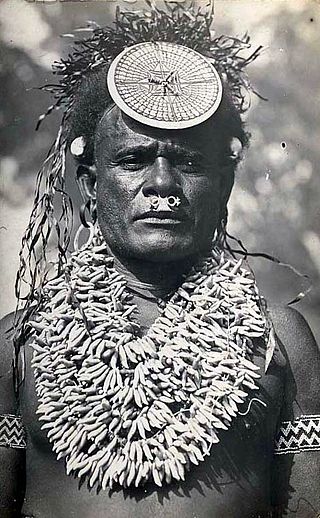
The culture of the Solomon Islands reflects the extent of the differentiation and diversity among the groups living within the Solomon Islands archipelago, which lies within Melanesia in the Pacific Ocean, with the peoples distinguished by island, language, topography, and geography. The cultural area includes the nation state of Solomon Islands and the Bougainville Island, which is a part of Papua New Guinea.

Temotu is the easternmost province of Solomon Islands. The province was formerly known as Santa Cruz Islands Province. It consists, essentially, of two chains of islands which run parallel to each other from the northwest to the southeast. Its area is 895 square kilometres.
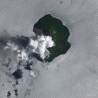
Tinakula is a conical stratovolcano which forms an island north of Nendo in Temotu Province, Solomon Islands. It lies at the north end of the Santa Cruz Islands. It is about 3.5 kilometres wide and rises 851 metres above sea level, rising three to four kilometres from the sea floor. The volcano was first recorded in eruption in 1595 when Álvaro de Mendaña sailed past it.
Utupua is an island in the Santa Cruz Islands, located 66 km to the Southeast of the main Santa Cruz group, between Vanikoro and Santa Cruz proper (Nendö). This island belongs administratively to the Temotu Province of Solomon Islands.

Nukapu is one of the islands of the nation of Solomon Islands. It is in the Reef Islands group in Temotu Province; the easternmost province of the Solomons. The estimated terrain elevation above sea level is 15 metres.

Vanikoro is an island in the Santa Cruz group, located 118 kilometres to the Southeast of the main Santa Cruz group. It is part of the Temotu Province of Solomon Islands.

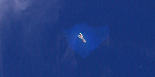
Nalongo and Nupani is a small atoll in Temotu Province, in the independent nation of Solomon Islands, in the southwestern Pacific Ocean. It has a coral reef totally encircling a 6 km wide lagoon. Nupani Island, also called Nimba, is inhabited with some 100 people, while Nalongo has no permanent habitation.

The Santa Cruz language is the main language spoken on the island of Nendö or 'Santa Cruz', in the Solomon Islands.
Nifiloli is an island in the Reef Islands, in Temotu Province, in the independent nation of Solomon Islands. The estimated terrain elevation above sea level is 19 metres. Despite its location in Melanesia, the population of the islands is Polynesian.
Fenualoa is the second largest island in the Reef Islands, in Temotu Province, in the nation of Solomon Islands.

The Solomon Islands (archipelago) is an island group in the western South Pacific Ocean, north-east of Australia. The archipelago is in the Melanesian subregion and bioregion of Oceania and forms the eastern boundary of the Solomon Sea. The many islands of the archipelago are distributed across Papua New Guinea and Solomon Islands (country). The largest island in the archipelago is Bougainville Island, which is a part of the Autonomous Region of Bougainville along with Buka Island, the Nukumanu Islands, and a number of smaller nearby islands. Much of the remainder falls within the territory of Solomon Islands and include the atolls of Ontong Java, Sikaiana, the raised coral atolls of Bellona and Rennell, and the volcanic islands of Choiseul, Guadalcanal, Makira, Malaita, New Georgia, the Nggelas, Santa Isabel, and the Shortlands. The Santa Cruz Islands are not a part of the archipelago.
Matema Island or Matema is of one of the Reef Islands in Temotu Province, of the independent nation of Solomon Islands.

Nendö is the largest of the Santa Cruz Islands, located in the Temotu province of Solomon Islands. The island is also known as Santa Cruz, Nendo, Ndeni, Nitendi or Ndende. The name Santa Cruz was given to the island in 1595 by the Spanish navigator Álvaro de Mendaña, who started a colony there. Historically, the island has also been called New Guernsey and Lord Egmont's Island, after John Perceval, 2nd Earl of Egmont, First Lord of the Admiralty.
Ngatendo is of one of the Reef Islands in Temotu Province, in the independent nation of Solomon Islands. The island is inhabited.
Tahua is one of the Duff Islands, of Temotu Province, in the independent nation of Solomon Islands. The estimated terrain elevation above sea level is some 23 metres. The island is inhabited.
10°15′S166°10′E / 10.250°S 166.167°E
| | This Solomon Islands location article is a stub. You can help Wikipedia by expanding it. |