Related Research Articles

The CaymanIslands is a self-governing British Overseas Territory, and the largest by population. The 264-square-kilometre (102-square-mile) territory comprises the three islands of Grand Cayman, Cayman Brac and Little Cayman, which are located south of Cuba and north-east of Honduras, between Jamaica and Mexico's Yucatán Peninsula. The capital city is George Town on Grand Cayman, which is the most populous of the three islands.

The Canary Islands, also known informally as the Canaries, are a Spanish region, autonomous community and archipelago in the Atlantic Ocean. At their closest point to the African mainland, they are 100 kilometres west of Morocco and the Western Sahara. They are the southernmost of the autonomous communities of Spain. The islands have a population of 2.2 million people and are the most populous special territory of the European Union.

Hawaii is an island state of the United States, in the Pacific Ocean about 2,000 miles (3,200 km) southwest of the U.S. mainland. It is the only state not on the North American mainland, the only state that is an archipelago, and the only state in the tropics.

Mauritius, officially the Republic of Mauritius, is an island country in the Indian Ocean, about 2,000 kilometres off the southeastern coast of East Africa, east of Madagascar. It includes the main island, as well as Rodrigues, Agaléga, and St. Brandon. The islands of Mauritius and Rodrigues, along with nearby Réunion, are part of the Mascarene Islands. The main island of Mauritius, where the population is concentrated, hosts the capital and largest city, Port Louis. The country spans 2,040 square kilometres (790 sq mi) and has an exclusive economic zone covering 2,300,000 square kilometres.

Madeira, officially the Autonomous Region of Madeira, is an autonomous region of Portugal. It is an archipelago situated in the North Atlantic Ocean, in the region of Macaronesia, just under 400 kilometres (250 mi) north of the Canary Islands, 520 kilometres (320 mi) west of the Kingdom of Morocco and 805 kilometres (500 mi) southwest of mainland Portugal. Madeira sits on the African Tectonic Plate, although it is culturally, politically and ethnically associated with Europe, with its population predominantly descended from Portuguese settlers. Its population was 251,060 in 2021. The capital of Madeira is Funchal, on the main island's south coast.
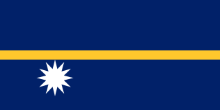
Nauru, officially the Republic of Nauru and formerly known as Pleasant Island, is an island country and microstate in Micronesia, part of the Oceania region in the Central Pacific. Its nearest neighbour is Banaba of Kiribati about 300 km (190 mi) to the east.

The Northern Mariana Islands, officially the Commonwealth of the Northern Mariana Islands (CNMI), is an unincorporated territory and commonwealth of the United States consisting of 14 islands in the northwestern Pacific Ocean. The CNMI includes the 14 northernmost islands in the Mariana Archipelago; the southernmost island, Guam is a U.S. territory. The Northern Mariana Islands were listed by the United Nations as a non-self-governing territory until 1990.

Oceania is a geographical region including Australasia, Melanesia, Micronesia, and Polynesia. Outside of the English-speaking world, Oceania is generally considered a continent, while Australia is regarded as an island or a continental landmass within that continent. Spanning the Eastern and Western Hemispheres, at the centre of the water hemisphere, Oceania is estimated to have a land area of about 9,000,000 square kilometres (3,500,000 sq mi) and a population of around 44.4 million as of 2022. Oceania is the smallest continent in land area and the second-least populated after Antarctica.

Puerto Rico, officially the Commonwealth of Puerto Rico, is a self-governing Caribbean archipelago and island organized as an unincorporated territory of the United States under the designation of commonwealth. Located about 1,000 miles (1,600 km) southeast of Miami, Florida, between the Dominican Republic in the Greater Antilles and the U.S. Virgin Islands in the Lesser Antilles, it consists of the eponymous main island and numerous smaller islands, including Vieques, Culebra, and Mona. With approximately 3.2 million residents, it is divided into 78 municipalities, of which the most populous is the capital municipality of San Juan, followed by those within the San Juan metropolitan area. Spanish and English are the official languages of the government, though Spanish predominates.
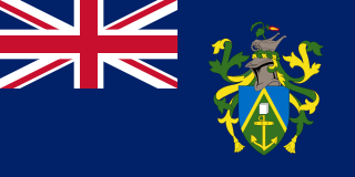
The Pitcairn Islands, officially Pitcairn, Henderson, Ducie and Oeno Islands, are a group of four volcanic islands in the southern Pacific Ocean that form the sole British Overseas Territory in the Pacific Ocean. The four islands—Pitcairn, Henderson, Ducie and Oeno—are scattered across several hundred kilometres of ocean and have a combined land area of about 47 square kilometres. Henderson Island accounts for 86% of the land area, but only Pitcairn Island is inhabited. The inhabited islands nearest to the Pitcairn Islands are Mangareva, 688 km to the west, as well as Easter Island, 1,929 km to the east.

Rhode Island is a state in the New England region of the Northeastern United States. It borders Connecticut to its west; Massachusetts to its north and east; and the Atlantic Ocean to its south via Rhode Island Sound and Block Island Sound; and shares a small maritime border with New York, east of Long Island. Rhode Island is the smallest U.S. state by area and the seventh-least populous, with slightly fewer than 1.1 million residents as of 2020; but it has grown at every decennial count since 1790 and is the second-most densely populated state, after New Jersey. The state takes its name from the eponymous island, though nearly all its land area is on the mainland. Providence is its capital and most populous city.

The United States Virgin Islands, officially the Virgin Islands of the United States, are a group of Caribbean islands and a territory of the United States. The islands are geographically part of the Virgin Islands archipelago and are located in the Leeward Islands of the Lesser Antilles. The islands have a tropical climate.

Easter Island is an island and special territory of Chile in the southeastern Pacific Ocean, at the southeasternmost point of the Polynesian Triangle in Oceania. The island is renowned for its nearly 1,000 extant monumental statues, called moai, which were created by the early Rapa Nui people. In 1995, UNESCO named Easter Island a World Heritage Site, with much of the island protected within Rapa Nui National Park.

Staten Island is the southernmost borough of New York City, coextensive with Richmond County and situated at the southernmost point of New York. The borough is separated from the adjacent state of New Jersey by the Arthur Kill and the Kill Van Kull and from the rest of New York by New York Bay. With a population of 495,747 in the 2020 Census, Staten Island is the least populated New York City borough but the third largest in land area at 58.5 sq mi (152 km2); it is also the least densely populated and most suburban borough in the city.

Territories of the United States are sub-national administrative divisions overseen by the federal government of the United States. The American territories differ from the U.S. states and Indian reservations as they are not sovereign entities. In contrast, each state has a sovereignty separate from that of the federal government and each federally recognized Native American tribe possesses limited tribal sovereignty as a "dependent sovereign nation". Territories are classified by incorporation and whether they have an "organized" government through an organic act passed by the Congress. American territories are under American sovereignty and may be treated as part of the U.S. proper in some ways and not others. Unincorporated territories in particular are not considered to be integral parts of the U.S., and the U.S. Constitution applies only partially in those territories.
Kazukuru is an extinct language that was once spoken in New Georgia, Solomon Islands. The Dororo and Guliguli languages were transcriptional variants, dialects, or closely related. The speakers of Kazukuru gradually merged with the Roviana people from the sixteenth century onward and adopted Roviana as their language. Kazukuru was last recorded in the early twentieth century when its speakers were in the last stages of language shift. Today, Kazukuru is the name of a clan in the Roviana people group.

The Falkland Islands is an archipelago in the South Atlantic Ocean on the Patagonian Shelf. The principal islands are about 300 mi (480 km) east of South America's southern Patagonian coast and about 752 mi (1,210 km) from Cape Dubouzet at the northern tip of the Antarctic Peninsula, at a latitude of about 52°S. The archipelago, with an area of 4,700 sq mi (12,000 km2), comprises East Falkland, West Falkland, and 776 smaller islands. As a British overseas territory, the Falklands have internal self-governance, but the United Kingdom takes responsibility for their defence and foreign affairs. The capital and largest settlement is Stanley on East Falkland.

The Faroe or Faeroe Islands, or simply the Faroes, are an archipelago in the North Atlantic Ocean and an autonomous territory of the Kingdom of Denmark. The official language of the country is Faroese, which is closely related to and partially mutually intelligible with Icelandic.
The family of Northwest Solomonic languages is a branch of the Oceanic languages. It includes the Austronesian languages of Bougainville and Buka in Papua New Guinea, and of Choiseul, New Georgia, and Santa Isabel in Solomon Islands.
References
- ↑ Ghanongga at Ethnologue (18th ed., 2015) (subscription required)