An earthquake occurred on July 17, 2006, at along a subduction zone off the coast of west and central Java, a large and densely populated island in the Indonesian archipelago. The shock had a moment magnitude of 7.7 and a maximum perceived intensity of IV (Light) in Jakarta, the capital and largest city of Indonesia. There were no direct effects of the earthquake's shaking due to its low intensity, and the large loss of life from the event was due to the resulting tsunami, which inundated a 300 km (190 mi) portion of the Java coast that had been unaffected by the earlier 2004 Indian Ocean earthquake and tsunami that was off the coast of Sumatra. The July 2006 earthquake was also centered in the Indian Ocean, 180 kilometers (110 mi) from the coast of Java, and had a duration of more than three minutes.
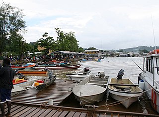
Gizo is the capital of the Western Province in Solomon Islands. With a population of 7,177, it is the third largest town in the country. It is situated on Ghizo Island approximately 380 kilometres west-northwest of the capital, Honiara, and is just southwest of the larger island of Kolombangara.
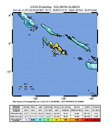
The 2007 Solomon Islands earthquake took place on 2 April 2007, near the provincial capital of Gizo on Ghizo Island, in the Solomon Islands. Its magnitude was estimated at 8.1 on the scale, and 7.8 on the scale. The tsunami that followed the earthquake killed 52 people. According to the USGS, the earthquake was recorded around 7:39:56 a.m. local time (UTC+11). The focus was 10 km (6 mi) deep and 40 km (25 mi) south southeast of Gizo township on New Georgia Islands in Western Province. There were numerous aftershocks, the largest of which had a magnitude of 6.2.

The September 2007 Sumatra earthquakes were a series of megathrust earthquakes that struck the Sunda Trench off the coast of Sumatra, Indonesia, with three of magnitude 7 or greater. A series of tsunami bulletins was issued for the area. The most powerful of the series had a magnitude of 8.4, which makes it in the top 20 of the largest earthquakes ever recorded on a seismograph.
The 2009 Swan Islands earthquake occurred on May 28 at with a moment magnitude of 7.3 and a maximum Mercalli intensity of VII. The epicenter was located in the Caribbean Sea, 64 kilometres (40 mi) northeast of the island of Roatán, 19 miles northeast of Port Royal, Isla de Bahias, 15 miles northwest of Isla Barbaretta, and 130 kilometres (81 mi) north-northeast of La Ceiba. Three aftershocks followed the earthquake within magnitude 4 range.
The 1995 Antofagasta earthquake occurred on July 30 at 05:11 UTC with a moment magnitude of 8.0 and a maximum Mercalli intensity of VII. The Antofagasta Region in Chile was affected by a moderate tsunami, with three people killed, 58 or 59 injured, and around 600 homeless. Total damage from the earthquake and tsunami amounted to $1.791 million.
The 2000 New Ireland earthquakes occurred off the coast of New Ireland Province, Papua New Guinea on November 16 and 17.

The 1833 Sumatra earthquake occurred on November 25 at about 22:00 local time, with an estimated magnitude in the range of 8.8–9.2 Mw . It caused a large tsunami that flooded the southwestern coast of the island. There are no reliable records of the loss of life, with the casualties being described only as 'numerous'. The magnitude of this event has been estimated using records of uplift taken from coral microatolls.
The 1912 Mürefte earthquake occurred at 03:29 local time on 9 August. It had an estimated magnitude of 7.4 and a maximum intensity of X (Extreme) on the Modified Mercalli intensity scale, causing from 216 to 3,000 casualties.
The 1996 Chimbote earthquake occurred on February 21 at about 130 km off the coast of northern Peru, near the Peru–Chile Trench. The earthquake had a moment magnitude of 7.5 and occurred at 25.0 km (15.5 mi) depth.

The Sagaing Fault is a major fault in Myanmar, a mainly continental right-lateral transform fault between the Indian Plate and Sunda Plate. It links the divergent boundary in the Andaman Sea with the zone of active continental collision along the Himalayan front. It passes through the populated cities of Mandalay, Yamethin, Pyinmana, the capital Naypyidaw, Toungoo and Pegu before dropping off into the Gulf of Martaban, running for a total length of over 1200 kilometers.

In seismology, a tsunami earthquake is an earthquake which triggers a tsunami of significantly greater magnitude, as measured by shorter-period seismic waves. The term was introduced by Japanese seismologist Hiroo Kanamori in 1972. Such events are a result of relatively slow rupture velocities. They are particularly dangerous as a large tsunami may arrive at a coastline with little or no warning.

The 1943 Alahan Panjang earthquakes occurred on June 8 and June 9 UTC in Sumatra, then under Japanese occupation. This was an earthquake doublet.
The 1907 Sumatra earthquake occurred on January 4 at 05:19:12 UTC. The re-estimated moment magnitude (Mw) is 8.2 to 8.4, with an epicentre close to Simeulue, off Sumatra. An earlier study re-estimated a surface-wave magnitude (Ms) of 7.5 to 8.0. It triggered a widespread and damaging Indian Ocean wide tsunami that caused at least 2,188 deaths on Sumatra. The low observed intensity compared to the size of the tsunami has led to its interpretation as a tsunami earthquake. Higher levels of shaking observed on Nias are attributed to a large aftershock, less than an hour later. The tsunami gave rise to the S'mong legend, which is credited with saving many lives during the 2004 earthquake.
The 1930 Bago (Pegu) earthquake, also known as the Swa earthquake struck Myanmar on 5 May. The moment magnitude (Mw ) 7.4 earthquake had a focal depth of 35 km (22 mi) and maximum Rossi–Forel intensity of IX. The earthquake was the result of rupture along a 131 km (81 mi) segment of the Sagaing Fault—a major strike-slip fault that runs through the country. Extensive damage was reported in the southern part of the country, particularly in Bago and Yangon, where buildings collapsed and fires erupted. At least 550, and possibly up to 7,000 people were killed. A moderate tsunami was generated along the Burmese coast which caused minor damage to ships and a port. It was felt for over 570,000 km2 (220,000 sq mi) and as far as Shan State and Thailand. The mainshock was followed by many aftershocks; several were damaging; additional earthquakes occurred in July and December, killing dozens. The December earthquake was similarly sized which also occurred along the Sagaing Fault.
In the early morning hours of Friday 24 December 2004, a moment magnitude 8.1 earthquake struck a remote area of the southern Tasman Sea. Its epicentre was located roughly 360 km (224 mi) northwest of the Auckland Islands of New Zealand, and roughly 600 km (373 mi) north of Macquarie Island of Australia. Shaking was reportedly felt as far as Tasmania and the South Island. The event was a complex intraplate earthquake within the Australian plate, which generated a small tsunami.
The 1843 Nias earthquake off the northern coast of Sumatra, Indonesia caused severe damage when it triggered a tsunami along the coastline. The earthquake with a moment magnitude (Mw ) of 7.8 lasted nine minutes, collapsing many homes in Sumatra and Nias. It was assigned a maximum modified Mercalli intensity of XI (Extreme).
The 1968 Aegean Sea earthquake was a 7.0 earthquake that occurred in the early morning hours of February 20, 1968 local time about 57.1 km (35.5 mi) away from Myrina, Greece. This earthquake occurred between mainland Greece and Turkey, meaning both countries were impacted. 20 people died, and 39 people were injured to various degrees. It was the deadliest Greek earthquake since the 1956 Amorgos earthquake.