Caguas is a city and municipality in central eastern Puerto Rico. Located in the eponymous Caguas Valley between the Sierra de Cayey and Sierra de Luquillo of the Central Mountain Range, it is bordered by San Juan and Trujillo Alto to the north, Gurabo and San Lorenzo to the west, Aguas Buenas, Cidra and Cayey to the east, and Patillas to the south. With a population of 127,244 as of the 2020 census, Caguas is the fifth most populated municipality in the archipelago and island and a principal city of the San Juan metropolitan area.

Bayamón is a city and municipality in Puerto Rico. Located on the northeastern coastal plain, it is bounded by Guaynabo to the east, Toa Alta and Naranjito to the west, Toa Baja and Cataño to the north, and Aguas Buenas and Comerío to the south. Part of the San Juan metropolitan area, Bayamón is spread over 11 barrios and the downtown area and administrative center of Bayamón Pueblo. With a population of 185,187 as of the 2020 census, it is the second most populated municipality in the archipelago and island after the capital of San Juan.

Aguas Buenas,, popularly known as "La Ciudad de las Aguas Claras" or "The City of Clear Waters", is a town and municipality of Puerto Rico located in the Central Mountain Range, north of Cidra, south of Bayamón, Guaynabo and San Juan; east of Comerio; and north-west of Caguas. Aguas Buenas is spread over 9 barrios and Aguas Buenas Pueblo. It is part of the San Juan-Caguas-Guaynabo Metropolitan Statistical Area.
Cidra is a town and municipality of Puerto Rico located in the central region of the island, north of Cayey; south of Comerío and Aguas Buenas; east of Aibonito and Barranquitas; and west of Caguas. Cidra is spread over 12 barrios and Cidra Pueblo. It is part of the San Juan-Caguas-Guaynabo Metropolitan Statistical Area.

Moca is a town and municipality of Puerto Rico, located in the north-western region of the island, north of Añasco; southeast of Aguadilla; east of Aguada; and west of Isabela and San Sebastián. Moca is spread over 12 barrios and Moca Pueblo. It is part of the Aguadilla-Isabela-San Sebastián Metropolitan Statistical Area.

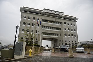
The Diocese of Caguas is a Latin Church ecclesiastical territory, or diocese, of the Catholic Church in southeastern Puerto Rico in the United States. It is a suffragan diocese in the ecclesiastical province of the metropolitan Archdiocese of San Juan de Puerto Rico

Instituto de Banca y Comercio (IBC) was a private, for-profit college-level institution with multiple locations in Puerto Rico. It offers short training programs and associate degrees. It is now known as NUC University IBC division.
The Puerto Rico Soccer League or PRSL is an association football league in Puerto Rico founded in 2008 and the first unified football league in the island's history. Association football had been growing in popularity in recent years, and this was an attempt to further develop the game on the island. The previous highest league in the country was the Campeonato Nacional de Fútbol de Puerto Rico. It shares Division I status with Liga Nacional de Fútbol de Puerto Rico.

Sevilla FC Puerto Rico was a Puerto Rican professional association football team based in Juncos, Puerto Rico. Founded in 2006, the team used to play in the Puerto Rico Soccer League. The club was founded in 2006 as a farm team for the Puerto Rico Islanders of the North American Soccer League in Bayamón, but in 2008 partnered with the Spanish La Liga club Sevilla FC and moved a year later to Juncos. Sevilla won both the regular season and play-offs in the inaugural season of the Puerto Rico Soccer League in 2008, and also won the regular season in 2011 before losing the play-off final on penalties to Leones.

The San Juan–Bayamón–Caguas metropolitan area, most commonly known as the San Juan metropolitan area, is the largest and most populous metropolitan statistical area (MSA) in Puerto Rico, concentrated in the capital municipality of San Juan and surrounding municipalities, including Bayamón, Caguas, and Carolina, on the northeastern coastal plain of the main island. One of 6 metropolitan statistical areas in Puerto Rico, it lies within the San Juan–Bayamón combined statistical area (CSA), which is one of 3 primary statistical areas in the main island as defined by the United States Census Bureau. As of 2023, census estimates place the population of the San Juan–Bayamón–Caguas metropolitan area at 2,035,733.

The Bayamón River is a river of Puerto Rico beginning at an elevation of approximately 1,476 ft in barrio Beatriz in Cidra, Puerto Rico. It is slightly over 30 miles long and travels through several municipalities: Cidra, Aguas Buenas, Guaynabo, Toa Baja, Bayamón, and Cataño, then empties into San Juan Bay.
Miss Universe Puerto Rico 2013 was the 58th Annual Miss Universe Puerto Rico pageant, held at the Centro de Bellas Artes de Santurce in San Juan, Puerto Rico, on August 29, 2012.
The 2016 Copa Luis Villarejo was the first edition of the Copa Luis Villarejo, a cup tournament for clubs in Puerto Rico organized by the Puerto Rican Football Federation. The champions and runners-up of this tournament are eligible to enter the 2017 Caribbean Club Championship, which serves as a qualifying tournament for the 2017 CONCACAF League and the 2018 CONCACAF Champions League.

Bairoa is a barrio or district in the municipality of Caguas, Puerto Rico. Its population in 2020 was 18,197. There are close to 60 sectors in Bairoa.
Starting on December 28, 2019, and progressing into 2020, the southwestern part of the island of Puerto Rico was struck by an earthquake swarm, including 11 that were of magnitude 5 or greater. The largest and most damaging of this sequence was a magnitude 6.4 , which occurred on January 7 at 04:24 AST (08:24 UTC), with a maximum felt intensity of VIII (Severe) on the Modified Mercalli intensity scale. At least one person was killed, and several others were injured.

The 1867 Virgin Islands earthquake and tsunami occurred on November 18, at 14.45 in the Anegada Passage about 20 km southwest of Saint Thomas, Danish West Indies. The Ms 7.5 earthquake came just 20 days after the devastating San Narciso Hurricane in the same region. Tsunamis from this earthquake were some of the highest ever recorded in the Lesser Antilles. Wave heights exceeded 10 m (33 ft) in some islands in the Lesser Antilles. The earthquake and tsunami resulted in no more than 50 fatalities, although hundreds of casualties were reported.
The 2010 Moca earthquake, also referred to as the 2010 Puerto Rico earthquake, occurred on May 16 at 1:16 a.m. local time in Moca, Puerto Rico. The earthquake measured 5.8 on the moment magnitude scale and had a maximum Mercalli intensity of VI (Strong). This was the largest earthquake to strike Puerto Rico since the 1943 Puerto Rico earthquake which measured 7.7 on the Richter scale. This was also the first moderate to major earthquake in recorded history to originate on land in Puerto Rico, as earthquakes in the region usually have their epicenter in the ocean; another earthquake with an epicenter on land would occur later in December of the same year.

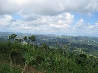
Altos de San Luis, also known as Monte Altos de San Luis, is an 886 feet high and two-mile-long prominent mountain ridge located on the northern edge of the Caguas Valley, in the barrio of Bairoa in the municipality of Caguas in the main island of Puerto Rico. The ridge is bordered by the Loíza River to the north and the east, and it forms part of a larger system of mountain ridges that extends from the southwestern end of the Sierra de Luquillo in Gurabo to the northeastern end of the Cordillera Central in Aguas Buenas. Other mountains and hills along this system include the Altos de La Mesa and Cerro La Marquesa. These ridges are shaped by the Great Northern Puerto Rico fault zone (GNPRfz), an active fault zone which crosses the island diagonally from southeast to northwest.

