Chittagong District

Last updated

Chittagong District
চট্টগ্রাম জেলা
Chattogram District
aandrkillaa shaahii jaame msjid (ddaan paarsher minaar).jpg
Chandranath Temple At Sitakunda (6).jpg
Mohamaya Lake , Mirsharai ,Chittagong,Bangladesh.jpg
Karnaphuli River at night (01).jpg
Clockwise from top-left: View of Agrabad, Anderkilla Shahi Jame Mosque, Mahamaya Lake, Port of Chittagong, Chandranath Temple at Sitakunda
Government Seal of Bangladesh.svg
BD Chittagong District locator map.svg
Chittagong District
Expandable map of Chittagong District
Coordinates: 22°20′15″N91°50′20″E / 22.3375°N 91.8389°E / 22.3375; 91.8389
CountryFlag of Bangladesh.svg  Bangladesh
Division Chittagong Division
Seat Chittagong
Government
   Divisional Commissioner Md. Tofayel Islam
   Deputy Commissioner Abul Bashar Mohammad Fakhruzzaman
   District Council Chairman A.T.M. Pearul Islam
Area
  Total5,282.92 km2 (2,039.75 sq mi)
  Rank2
Population
 (2022 census) [1]
  Total9,169,464
  Rank2
  Density1,700/km2 (4,500/sq mi)
Time zone UTC+06:00 (BST)
HDI (2019)0.654 [2]
medium · 3rd of 20
Website chittagong.gov.bd

Chittagong District, renamed the Chattogram District, [3] is a district located in south-eastern Bangladesh. It is a part of the Chittagong Division. The port city of Chittagong, which is the second largest city in Bangladesh, is located within this district.

Contents

Geography

Chittagong district is situated along the southeastern coast of Bangladesh, between the Bay of Bengal to the west, Cox's Bazar district to the south, the Chittagong Hill Tracts to the east, the Indian state of Tripura to the north and Feni district to the northwest. Within the Bay of Bengal is the island of Sandwip and several nearby islands, which together form an upazila of the district.

The district's topography is primarily defined by a series of low hill ranges running roughly parallel to the coast and with each other. Between these hill ranges are broad alluvial valleys with sandstone bedrock, and they are also divided by several major rivers, namely the Karnaphuli and Sangu. The most important of these ranges runs roughly from the tripoint with Feni district and Tripura in the north southeast to Chittagong city, known as the Sitakunda hills. This hill range is around 70 kilometres in length and its highest point, Chandranath, is around 350 metres in height. Along the eastern border with Khagrachhari district lies broken hill country. [4] Another set of hills enters the district in the western part of Rangunia Upazila and ends at the Karnaphuli. South of the Karnaphuli, the hills run southeast through the eastern part of Patiya and Chandanaish upazilas to the Sangu River. South of the Sangu lies another hill range close to the coast which divides Banskhali Upazila from Satkania and Lohagara Upazilas, and continues into Cox's Bazar district. The southeastern border with Bandarban district lies along the foothills of the Hill Tracts. To the west of the hill ranges lies a coastal plain with a small width, [4] and along the shore there are numerous beaches which have become tourist destinations.

Rivers

The major rivers running through Chittagong district are the Feni, Karnaphuli and Sangu. [4]

The Feni arises in Tripura state, and forms the entire border between Tripura and Chittagong district. It separates the Sitakunda hill range from the hill ranges in Tripura to the north. After fully entering Bangladesh, it flows southwest, meandering slightly, roughly along the border between Mirsharai Upazila with Feni district before entering the Bay of Bengal amid tidal flats. [4]

The Karnaphuli enters Chittagong district at Chandraghona in Rangunia Upazila. It goes through several large meanders and divides the Patiya hill range from the hills to their north. It flows west before turning southwest near Boalkhali and forms the southern limits of Chittagong city, entering the sea near Patenga thana. One of its main tributaries is the Halda river. The Halda arises in the Chittagong Hill tracts and flows west into Fatikchhari Upazila. It then turns southeast, flowing past Fatikchhari and Hathazari before entering the Karnaphuli near the northeasternmost part of Chittagong city. [4]

The Sangu river arises in Bandarban district of the Chittagong Hill Tracts, and enters Chittagong district at Dhopachari in Chandanaish Upazila. It forms most of the border between Chandanaish and Satkania upazilas, as well as between Anowara and Banshkhali upazilas, before entering the sea 16 kilometres south of the mouth of the Karnaphulil. [4]

There are several khals also in the district.

History

Because of the natural harbour, Chittagong had been an important location for trade, drawing Arab traders as early as the 9th century CE. The region fell under the rule of kings from Arakan in the 16th and 17th centuries, but later, the Mughal Army under Shaista Khan conquered Chittagong. During the 17th century, the region also faced a lot of attacks by Portuguese pirates, who occupied Sandwip for a long time. The Mughals established Chittagong as a district in 1666. Chittagong is the 2nd largest district in Bangladesh by population and area. The Chittagong Hill Tracts were separated from Chittagong in 1860. In 1947, Chittagong came under Pakistan and became part a district of East Pakistan. Port of Chittagong was a big spot for exports and imports of Pakistan. After the liberation of Bangladesh, Cox's Bazar District was separated in 1984. [5]

Administration

Subdivisions

There are 15 upazilas [8] and 33 thanas [9] within Chittagong District. There are 16 Thanas for the Chattogram Metropolitan Police covered area including the Karnaphuli Upazila, 2 for Fatikchhari Upazila, 2 for Mirsharai Upazila, and 1 for each of the remaining 13 upazilas.

The upazilas are:

  1. Anwara Upazila
  2. Banshkhali Upazila
  3. Boalkhali Upazila
  4. Chandanaish Upazila
  5. Fatikchhari Upazila
  6. Hathazari Upazila
  7. Karnaphuli Upazila [10]
  8. Lohagara Upazila
  9. Mirsharai Upazila
  10. Patiya Upazila
  11. Rangunia Upazila
  12. Raozan Upazila
  13. Sandwip Upazila
  14. Satkania Upazila
  15. Sitakunda Upazila

The thanas for the Chattogram Metropolitan Police covered area are:

  1. Akbar Shah Thana
  2. Bakoliya Thana
  3. Bandar Thana
  4. Bayazid Bostami Thana
  5. Chandgaon Thana
  6. Chawkbazar Thana
  7. Chittagong Kotwali Thana
  8. Double Mooring Thana
  9. EPZ Thana
  10. Halishahar Thana
  11. Karnaphuli Thana
  12. Khulshi Thana
  13. Pahartali Thana
  14. Panchlaish Thana
  15. Patenga Thana
  16. Sadarghat Thana

The thanas for the Fatikchhari Upazila are:

  1. Bhujpur Thana
  2. Fatikchhari Thana

The thanas for the Mirsharai Upazila are:

  1. Jorargonj Thana
  2. Mirsharai Thana

Demographics

Historical population
YearPop.±% p.a.
1974 3,506,150    
1981 4,465,158+3.51%
1991 5,296,127+1.72%
2001 6,612,140+2.24%
2011 7,616,352+1.42%
2022 9,169,465+1.70%
Sources: [11] [12]

According to the 2022 Census of Bangladesh, Chittagong District had 2,143,909 households and a population of 9,169,465. The population density was 1,736 people per km2. 1,729,570 (18.86%) were under 10 years of age. Chittagong district had a literacy rate (age 7 and over) of 81.06%, compared to the national average of 74.8%, and a sex ratio of 1006 females per 1000 males. 4,885,216 (53.28%) lived in urban areas. [11]

Religion

Religions in Chittagong District (2022) [11]
ReligionPercent
Islam
87.53%
Hinduism
10.72%
Buddhism
1.63%
Other or not stated
0.12%
Religion in present-day Chittagong district [lower-alpha 1]
ReligionPopulation (1941) [13] :102–103Percentage (1941)Population (2022) [11] Percentage (2022)
Islam Star and Crescent.svg 1,402,13072.49%8,025,72287.53%
Hinduism Om.svg 470,02624.30%982,56810.72%
Buddhism Dharma Wheel (2).svg ------149,7731.63%
Others [lower-alpha 2] 62,2123.22%10,9760.12%
Total Population1,934,368100%9,169,039100%

Chittagong is multi-religious. In 2011 Muslims were 86.90%, while Hindus and Buddhists were 11.31% and 1.59% respectively. Chittagong has the largest population of Hindus of any district in Bangladesh. All religions are increasing in numbers, with Hindus and Buddhists growing more slowly.

Chittagong District has 13,148 mosques, 1025 Hindu temples, 535 Buddhist temples and 192 churches. Fakira Mosque in Hathazari, Musa Khan Mosque, Hafez Para Jame Mosque in Putibila, Lohagara, Kura Katni Mosque, Hashimpur Kadam Rasool Mosque in Chandanaish, the 16th century Kala Mosques, Chhuti Khan Mosque, Kadam Mobara Mosque, Andar Killah Mosque, Bakshi Hamid Mosque of Bashkhali, and East Gomdandi Chowdhury Para Old Mosque of Boalkhali are famous mosques in Chittagong. Also Badar Awlia Dargah is a tomb in Chittagong. [14]

In 2011, the ethnic population was 32,165, consisting mainly of Tripuris and Chakmas. In 2022, this increased to 48,245 (0.53% of the population).

Language in Chittagong District (1931) [15]

   Bengali (98.17%)
   Assam-Burmese (1.31%)
   Hindustani (0.32%)
   Naipali (0.04%)
   Dravidian languages (0.02%)
  Others (0.15%)

Education

Colleges

Universities

Others

Language and culture

The official language of Chittagong is Standard Bengali. However, the language spoken here is the Chittagonian, [16] which has its own grammar, phonology and vocabulary.

Notable people

See also

Notes

  1. Sadar subdivision of Chittagong district and Sandwip thana of Noakhali district
  2. Including Jainism, Christianity, Buddhism, Zoroastrianism, Judaism, Ad-Dharmis, or not stated

Related Research Articles

<span class="mw-page-title-main">Feni District</span> District of Bangladesh in Chittagong Division

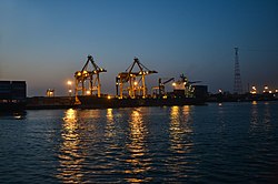
Feni is a coastal district situated in the south-east of Bangladesh, within the Chittagong Division. One of Bangladesh's smallest districts, it is strategically located along the Dhaka–Chittagong transportation corridor. Bordered by India to the north and the Bay of Bengal to the south, it serves as the sole entry point linking Chittagong, the country's primary port city, to the northern districts.

<span class="mw-page-title-main">Chandanaish Upazila</span> Upazila in Chattogram Division, Bangladesh

Chandanaish is an upazila of Chattogram District in Chattogram Division, Bangladesh.

<span class="mw-page-title-main">Fatikchhari Upazila</span> Upazila in Chittagong Division, Bangladesh

Fatikchari(Bengali: ফটিকছড়ি, romanized: Fôṭikchhôṛi) is an upazila of Chittagong District in Chittagong Division, Bangladesh. It is the largest Upazila of Chittagong.

<span class="mw-page-title-main">Hathazari Upazila</span> Upazila in Chattogram Division, Bangladesh

Hathazari is an upazila of Chattogram District in Chattogram Division, Bangladesh.

<span class="mw-page-title-main">Lohagara Upazila, Chittagong</span> Upazila in Chattogram Division, Bangladesh

Lohagara is an upazila of Chattogram District in Chattogram Division, Bangladesh. Lohagara is situated between Chattogram and Cox's Bazar. It is one of the largest and most densely populated upazilas of Bangladesh. It has headquarters in Lohagara.

<span class="mw-page-title-main">Mirsharai Upazila</span> Upazila in Chattogram Division, Bangladesh

Mirsharai Upazila is an upazila of Chattogram District in Chattogram Division, Bangladesh. It comprises two police stations and two municipalities.

<span class="mw-page-title-main">Raozan Upazila</span> Upazila in Chattogram Division, Bangladesh

Raozan Upazila is an upazila of Chattogram District, in Chattogram Division, Bangladesh. It was established in August,1947.

<span class="mw-page-title-main">Sandwip Upazila</span> Upazila in Chattogram Division, Bangladesh

Sandwip is an upazila of Chattogram District in Chattogram Division, Bangladesh. It encompasses the islands of Sandwip and Urir Char.

<span class="mw-page-title-main">Satkania Upazila</span> Upazila in Chattogram Division, Bangladesh

Satkania is an upazila of Chattogram District in Chattogram Division, Bangladesh.

<span class="mw-page-title-main">Sitakunda Upazila</span> Upazila in Chattogram Division, Bangladesh

Sitakunda is an upazila in the Chattogram District of Chattogram Division, Bangladesh. It includes one urban settlement, the Sitakunda Town, and 10 unions. Sitakunda is the home of the country's first eco-park, as well as alternative energy projects, specifically wind energy and geothermal power.

<span class="mw-page-title-main">Companiganj Upazila, Noakhali</span> Upazila in Chittagong, Bangladesh

Companiganj is an upazila of Noakhali District. Basurhat is the only municipality in this upazila. The area is famed for water buffalo doi (curd).

<span class="mw-page-title-main">Halda River</span>

Halda River is a river in south-eastern Bangladesh. It originates at the Badnatali Hill Ranges in Ramgarh Upazila in the Chittagong Hill Tracts, flows through Fatikchhari Upazila, Bhujpur Thana, Hathazari Upazila, Raozan Upazila and Chandgaon Thana of the Chittagong Metropolitan City, and falls into the Karnaphuli River. The 81-kilometre-long (50 mi) river has a very turbulent tributary, the Dhurung River, which joins Purba Dhalai about 48 kilometres (30 mi) downstream. The river is navigable by big boats 29 km (18 mi) from its mouth up to Nazir Hat, and by small boats 16–24 kilometres (9.9–14.9 mi) further up to Narayanhat. The Halda averages 21 feet (6.4 m) in depth and is 30 feet (9.1 m) at its deepest point.

Suabil Union is a union of Bhujpur Thana of Chittagong District.

<span class="mw-page-title-main">Sangu River</span> River in Bangladesh

The Sangu River is a river in Myanmar and Bangladesh. Its source is in the North Arakan Hills of Myanmar, located at 21°13´N 92°37´E. The Arakan Hills form the boundary between Arakan and the Chittagong Hill Tracts. It follows a northerly circuitous course in the hill tracts and then enters Bangladesh near Remaikri, Thanchi Upazila, Bandarban District, from the east. It flows north through Thanchi, Rowangchhari and Bandarban Sadar Upazilas of Bandarban district. It then flows west through Satkania and Banshkhali Upazilas in Chittagong district and flows into the Bay of Bengal near Chittagong, at 22°6´N 91°51´E, or about 16.09 kilometres (10.00 mi) south of the mouth of the Karnafuli River. The length of the river is 270 kilometres (170 mi) of which 173 kilometres (107 mi) are located within Bangladesh.

The N1 or Dhaka–Chittagong Highway is the main transportation artery of Bangladesh, connecting the capital city of Dhaka and the southern port city of Chittagong. Approximately 465 kilometres in length, the highway starts at Jatrabari in Dhaka and ends at Teknaf in Cox's Bazar. The highway is known along certain stretches as the Chittagong–Cox's Bazar Highway and the Cox's Bazar–Teknaf Highway.

Betagi is a Union Council of Rangunia Upazila in Chittagong District, Chittagong Division, Bangladesh.

<span class="mw-page-title-main">Chittagong-13</span> Constituency of Bangladeshs Jatiya Sangsad

Chittagong-13 is a constituency represented in the Jatiya Sangsad of Bangladesh since 2014 by Saifuzzaman Chowdhury of the Awami League.

<span class="mw-page-title-main">Chittagong-14</span> Bangladeshi parliamentary constituency

Chittagong-14 is a constituency represented in the Jatiya Sangsad of Bangladesh since 2014 by Nazrul Islam Chowdhury of the Awami League.

<span class="mw-page-title-main">History of Noakhali</span>

The Greater Noakhali region predominantly includes the districts of Noakhali, Feni and Lakshmipur in Bangladesh, though it has historically also included Bhola, Sandwip and some southern parts of Tripura in India and southern Comilla. The history of the Noakhali region begins with the existence of civilisation in the villages of Shilua and Bhulua. Bhulua became a focal point during the Buddhist and Hindu kingdoms of Pundra, Harikela and Samatata leading it to become the initial name of the region as a whole. The medieval Kingdom of Bhulua enjoyed autonomy under the Twipra Kingdom and Bengal Sultanate before being conquered by the Mughal Empire. At the beginning of the 17th century, Portuguese pirates led by Sebastian Gonzales took control of the ara but were later defeated by Governor Shaista Khan. Affected by floodwaters, the capital of the region was swiftly moved to a new place known as Noakhali, from which the region presently takes its name. By 1756, the British East India Company had dominated and started to establish several factories in the region. The headquarters was once again moved in 1951, to Maijdee, as a result of Noakhali town vanishing due to fluvial erosion.

References

  1. Population and Housing Census 2022: Preliminary Report. Bangladesh Bureau of Statistics. August 2022. pp. viii, 29, 38, 45. ISBN   978-984-35-2977-0.
  2. "Sub-national HDI - Area Database - Global Data Lab". hdi.globaldatalab.org. Retrieved 18 March 2020.
  3. Mahadi Al Hasnat (2 April 2018). "Mixed reactions as govt changes English spellings of 5 district names". Dhaka Tribune. Retrieved 8 April 2018.
  4. 1 2 3 4 5 6 OʼMalley, L. S. S. (1908). Eastern Bengal district gazetteers Chittagong.
  5. Mohammad Mahibbullah Siddiqi (2012). "Cox's Bazar District". In Sirajul Islam and Ahmed A. Jamal (ed.). Banglapedia: National Encyclopedia of Bangladesh (Second ed.). Asiatic Society of Bangladesh.
  6. "AL men appointed administrators". The Daily Star. 16 December 2011.
  7. মো. ইলিয়াস হোসেন চট্টগ্রাম বিভাগের শ্রেষ্ঠ জেলা প্রশাসক. Chittagong Pratidin (in Bengali). 27 January 2020. Retrieved 5 July 2020.
  8. Jasim Uddin Harun (2012). "Chittagong District". In Sirajul Islam and Ahmed A. Jamal (ed.). Banglapedia: National Encyclopedia of Bangladesh (Second ed.). Asiatic Society of Bangladesh.
  9. "Home Minister to launch 4 new thanas in Ctg tomorrow". The Financial Express. 29 May 2013.
  10. "Karnaphuli becomes Bangladesh's 490th Upazila". bdnews24.com. 9 May 2016.
  11. 1 2 3 4 National Report (PDF). Population and Housing Census 2022. Vol. I. Dhaka: Bangladesh Bureau of Statistics. November 2023. pp. 143, 151, 179, 191, 265. ISBN   9789844752016.
  12. "Bangladesh Population and Housing Census 2011 Zila Report – Chittagong" (PDF). bbs.gov.bd. Bangladesh Bureau of Statistics.
  13. "Census of India, 1941 Volume VI Bengal Province" (PDF).
  14. চট্টগ্রামের সবচেয়ে প্রাচীন ইমারত. Prothom Alo (in Bengali). 22 August 2013. Retrieved 5 July 2020.
  15. Census of India 1931
  16. Masica, Colin (1991). The Indo-Aryan Languages. Cambridge: Cambridge University Press. p. 16. "The dialect of Chittagong, in southeast Bangladesh, is different enough to be considered a separate language."
  17. "Nurul Abedin Profile". ESPNcricinfo.