Comilla District

Last updated

Comilla
কুমিল্লা জেলা
Cumilla District
Aerial view of Comilla city from a high-rise building 2.jpg
Shah Shuja Mosque, 2019-01-05 (02).jpg
Shalban Vihara (2).jpg
Nawab Faizunnesa House at Laksham, Comilla, 19 April 2017 07.jpg
gomtii ndii, kumillaa.jpg
Clockwise from top-left: Skyline of Comilla, Shah Shuja Mosque, Nawab Faizunnesa House at Laksam, Gomti River, Shalban Vihara in Mainamati
BD Cumilla District locator map.svg
Location of Comilla within Bangladesh
Comilla District
Expandable map of Comilla
Coordinates: 23°16′N91°07′E / 23.27°N 91.12°E / 23.27; 91.12
CountryFlag of Bangladesh.svg  Bangladesh
Division Chittagong Division
Capital Comilla
Government
   Deputy Commissioner Md. Kamrul Hasan [1]
   District Council Chairman Abu Taher [2]
  Chief Executive OfficerMd. Helal Uddin [3]
Area
  Total3,146.30 km2 (1,214.79 sq mi)
Population
 (2022 census) [4]
  Total6,212,216
  Density2,000/km2 (5,100/sq mi)
Time zone UTC+06:00 (BST)
HDI (2018)0.614 [5]
medium · 7th of 21
Notable sport teams Comilla Victorians
Website www.comilla.gov.bd

Comilla District, officially known as Cumilla District, [6] is a district located in southeastern Bangladesh. It lies about 100 kilometres south east of Dhaka. Comilla is bordered by Brahmanbaria and Narayanganj districts to the north, Noakhali and Feni districts to the south, Tripura state of India to the east and Munshiganj and Chandpur districts to the west. [7]

Contents

History

World War II cemetery in Mainamati. WW2 Cemetery Moinamoti 003.jpg
World War II cemetery in Mainamati.

The name Comilla is derived from the Bengali word Komolangko (Bengali : কমলাঙ্ক), the previous ancient name of the region, which means 'lotus pond'. The present Comilla is a district under the Chittagong Division. It was once under the reign of Gangaridai and Samatata in ancient period. As far as is known from the ancient archeology found in the region, Gupta emperors ruled Comilla since the fifth century AD. It was under the control of Gauda Kingdom in 6th century AD after the fall of Gupta rule in Bengal. [8] According to historians, the Buddhist Deva dynasty ruled the region from the seventh to the middle of the eighth century. In the ninth century, Comilla came under the control of the kings of Harikela and Chandra dynasty during the tenth and mid-eleventh century AD. The region became a part of Hindu Sena and Deva dynasty before the invasion of Muslim rulers in this region. Comilla became part of the kingdom of Tripura in mediaeval period. Later on, it was ruled by the Mughals and then it came under the rule of East India Company in 1765.

In order to facilitate revenue collection, the company hired a district collector in the province in 1769. Comilla then belonged to the province of Dhaka. Comilla was made under the office of the district collector in 1776. The Tripura Collector's journey began with the formation of Tippera or Tipperah district of Bengal by the British in 1790. [9] According to the Third Regulation in 1793, a civil judge was appointed for the Tripura district and in that year he was given magisterial powers. In 1837, the posts of magistrates and collectors were separated. In 1859, these two posts were merged again. After the partition in 1947, the district was renamed Comilla in 1960 and the post of district magistrate and collector was named deputy commissioner. [10] Chandpur and Brahmanbaria sub-divisions of this district became districts in 1984.

Geography and climate

Comilla has a total area of 3146.30.17 square kilometres. It is bounded by Brahmanbaria district and Narayanganj district of Dhaka division to the north, Munshiganj district of Dhaka division and Chandpur district to the west, Noakhali and Feni districts to the south and the Indian state of Tripura to the east. The district headquarters of Comilla is located close to the Indian border, with the town of Sonamura on the other side. Major rivers passing through Comilla include the Gumti and the Little Feni. It is hot in summer and cold in winter. [7]

The district is primarily plain land.

Administration

The administrative headquarters of Comilla are located in the city of Comilla which has a total area of 11.47 square kilometres. It consists of 18 mouzas and 3 wards. Comilla thana was officially converted into an upazila in 1983 which contains one municipality, 18 wards, 19 union parishads, 452 mouzas, and 458 villages. [7]

Administrator of Zila Parishad: M. Omar Faruque [11]

Deputy Commissioner (DC): Md Jahangir Alam [12]

Subdistricts

Comilla district consists of the following Upazilas: [13]

  1. Barura Upazila
  2. Brahmanpara Upazila
  3. Burichong Upazila
  4. Comilla Sadar Upazila
  5. Comilla Sadar Dakshin Upazila
  6. Chandina Upazila
  7. Chauddagram Upazila
  8. Daudkandi Upazila
  9. Debidwar Upazila
  10. Homna Upazila
  11. Laksam Upazila
  12. Lalmai Upazila
  13. Monohorgonj Upazila
  14. Meghna Upazila
  15. Muradnagar Upazila
  16. Nangalkot Upazila
  17. Titas Upazila

Demographics

Historical population
YearPop.±% p.a.
1974 2,802,944    
1981 3,355,953+2.61%
1991 4,032,666+1.85%
2001 4,595,557+1.32%
2011 5,387,288+1.60%
2022 6,212,216+1.30%
Sources: [4] [14]

According to the 2022 Census of Bangladesh, Comilla District had 1,407,368 households and a population of 6,212,216. The population density was 1,974 people per km2. Comilla district had a literacy rate (age 7 and over) of 76.68%, compared to the national average of 74.80%, and a sex ratio of 1142 females per 1000 males. 1,356,351 (21.83%) were under 10 years of age. 20.43% of the population lived in urban areas. [4]

Religions in Comilla district (2022) [4]
ReligionPercent
Islam
95.56%
Hinduism
4.33%
Other or not stated
0.11%
Religion in present-day Comilla district [lower-alpha 1]
ReligionPopulation (1941) [15] :102–103Percentage (1941)Population (2022) [4] Percentage (2022)
Islam Star and Crescent.svg 1,407,4945,936,146
Hinduism Om.svg 340,010269,206
Others [lower-alpha 2] 2,8046,864
Total Population1,750,3086,212,216

Muslims make up 95.56% of the population, while Hindus are 4.33% of the total population. Formerly a centre of Buddhism, there are now only 6,000 Buddhists in the district, concentrated in Lalmai Upazila. [14]

Economy

Manufacturers of popular Comilla sweetmeats are mostly based on this Manoharpur area of the main town. Manoharpur Sweetmeat Hub.jpg
Manufacturers of popular Comilla sweetmeats are mostly based on this Manoharpur area of the main town.

Mainly based on agriculture, the economy of Comilla has flourished through trade and cottage industries, especially the 'Khadi' textile. For the economic development of the region the "Bangladesh Export Processing Zone Authority" has established the "Comilla Export Processing Zone" spread over an area of 104.44 hectares (258.1 acres) in the Comilla Airport area in 2000. [16] The export zone employs 20 thousand people as of 2013. [17]

Places of interest

Landmarks include Kotbari, a cantonment, or military installation and Kandirpar, considered the heart of the Comilla district. Ancient Buddhist monastery ruins are the major attraction of Mainamati, near Kotbari. There is an ancient Hindu Temple named Comilla Jagannath Temple located on East Bibirbazar Road. There is also the recently constructed Allah Chattar, a tower in Muradnagar.

A Second World War cemetery, Mainamati War Cemetery, lies about 3.1 kilometres (1.9 mi) away from Comilla Cantonment, which was a frontier military base in the fight against the Japanese who had occupied Burma. British Army soldiers killed during the fight with the Japanese Army at the Burma (Myanmar) frontier were buried here. [18] Pashchimgaon Nawab Bari, the place of only lady Jaminder Nawab Faizunnesa, a poet, educationist and a philanthropist. [19]

Kazi Nazrul Islam, the national poet of Bangladesh, passed a significant time of his life in this town. Both his wives, Promila Devi and Nargis, hailed from this district. [20]

Comilla Victoria College and Comilla Zilla School are here, the latter since 1837. [21] Bangladesh Academy for Rural Development (BARD) is situated in Kotbari. The area saw the development of Comilla Model. [22]

Education

Notable people

The following people were either born or stayed in this district for a significant span of their lifetime:

See also

Notes

  1. Sadar subdivision of Tippera district
  2. Including Jainism, Christianity, Buddhism, Zoroastrianism, Judaism, Ad-Dharmis, or not stated

Related Research Articles

<span class="mw-page-title-main">Feni District</span> District of Bangladesh in Chittagong Division

Feni is a coastal district situated in the south-east of Bangladesh, within the Chittagong Division. One of Bangladesh's smallest districts, it is strategically located along the Dhaka–Chittagong transportation corridor. Bordered by India to the north and the Bay of Bengal to the south, it serves as the sole entry point linking Chittagong, the country's primary port city, to the northern districts.

<span class="mw-page-title-main">Chittagong Division</span> Division of Bangladesh

Chittagong Division, officially known as Chattogram Division, is geographically the largest of the eight administrative divisions of Bangladesh. It covers the south-easternmost areas of the country, with a total area of 34,529.97 km2 (13,332.10 sq mi) and a population at the 2022 census of 33,202,326. The administrative division includes mainland Chittagong District, neighbouring districts and the Chittagong Hill Tracts.

<span class="mw-page-title-main">Chandpur District</span> District of Bangladesh in Chittagong Division

Chandpur District (চাঁদপুর) is a district located in Chattogram Division of Bangladesh. It was part of the Comilla District until 15 February 1984.

<span class="mw-page-title-main">Brahmanbaria District</span> District of Bangladesh in Chattogram Division

Brahmanbaria is a district in eastern Bangladesh located in the Chittagong Division. Geographically, it is mostly farmland and is topographically part of the Gangetic Plain. It is bounded by the districts of Kishoreganj and Habiganj to the north, Narsingdi District and Narayanganj to the west, Comilla to the south, and the Indian state of Tripura to the east. It was a part of Comilla District until 15 February 1984.

<span class="mw-page-title-main">Khagrachhari District</span> District in Chittagong Division, Bangladesh

Khagrachari is a district in the Chittagong Division of Southeastern Bangladesh. It is a part of the Chittagong Hill Tracts region.

<span class="mw-page-title-main">Nabinagar Upazila</span> Upazila in Chittagong, Bangladesh

Nabinagar is an upazila of Brahmanbaria District in the Division of Chattogram, Bangladesh. Nabinagar Thana was turned into an upazila in 1983.

<span class="mw-page-title-main">Chauddagram Upazila</span> Region of Chittagong Division, Bangladesh

Chauddagram is an upazila of Cumilla District in the Division of Chittagong, Bangladesh. It also a Municipality under Cumilla District.Chauddagram Municipality is a part of Chauddagram Upazila. A municipality in Comilla district of Bangladesh.

<span class="mw-page-title-main">Laksam Upazila</span> Upazila in Chittagong, Bangladesh

Laksam is an upazila of Comilla District in the Division of Chittagong, Bangladesh. Laksam is widely known as the birthplace of Nawab Faizunnesa Chowdhurani.

<span class="mw-page-title-main">Nangalkot Upazila</span> Upazila in Chittagong, Bangladesh

Nangalkot is an upazila, an administrative unit, of the Comilla District in the Division of Chittagong, Bangladesh. It is a rural area with no urban settlements. It has 16 unions, the lowest of administrative units in Bangladesh. It is one of the 16 upazilas, the second tier of administrative units, of the Cumilla District.The language and culture of Nangalkot Upazila is reciprocally similar to the language of the greater Noakhali region.

<span class="mw-page-title-main">Boalmari Upazila</span> Upazila in Dhaka, Bangladesh

Boalmari is an upazila (sub-district) of Faridpur District in central Bangladesh, located in the Dhaka Division. It is named after its headquarters, the town of Boalmari.

<span class="mw-page-title-main">Comilla</span> City in eastern Bangladesh

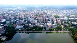
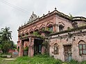
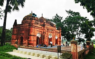
Comilla, officially spelled Cumilla, is a metropolis on the banks of the Gomti River in eastern Bangladesh. Comilla was one of the cities of ancient Bengal. It was once the capital of Tripura kingdom. Comilla Airport is located in the Dulipara area of Comilla city. Along with the Comilla Economic Zone EPZ, various industrial factories have come up at the airport, making the airport area a business and commercial city. Comilla City is a division centered city district with surrounding districts coming to Comilla in more diverse areas of work. Bibir Bazar land port is located 5 km away from Comilla city. The area of Comilla City Corporation is 53.04 square kilometers, so the surrounding areas of the main city fall under the jurisdiction of the City Corporation. The urban areas falling outside the city corporation are considered as suburbs with a population of 600,000.

Comilla Victoria Government College is a government college in Comilla, Bangladesh. It is one of the oldest and most renowned colleges in Comilla as well as in the Chittagong division. The college is located beside of Ranir Dighi on 32 acres of land including its intermediate and honors section.

<span class="mw-page-title-main">Districts of Bangladesh</span> Second-level administrative divisions of Bangladesh

The divisions of Bangladesh are further divided into districts or zilas. The headquarters of a district is called the district seat. There are 64 districts in Bangladesh. The districts are further subdivided into 495 subdistricts or upazilas.
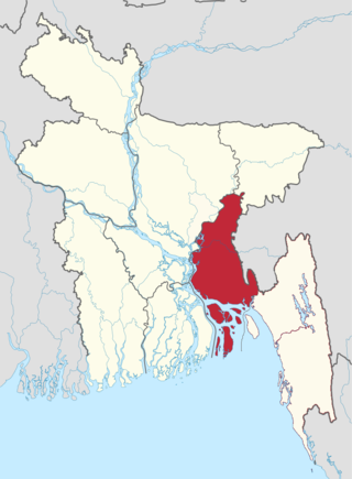
<span class="mw-page-title-main">Meghna Division</span> Proposed division in Bangladesh

Meghna Division is a proposed administrative division within Bangladesh for the north-western parts of the existing Chittagong Division, comprising Brahmanbaria, Comilla, Chandpur, Noakhali, Feni, and Laxmipur Districts of Chittagong Division. The headquarter of the division is in Comilla. It covers the south-easternmost areas of the country, with a total area of 12,848.53 km2 (4,960.85 sq mi) and a population at the 2011 census of 16,708,000.

Comilla is a most popular city in Bangladesh. There are many schools in the city. As of 2018 the number of the primary schools in the city was 2,102.

Abdul Quadir was a Bangladeshi poet, essayist, and journalist. He was the recipient of Bangla Academy Literary Award in 1963 and Ekushey Padak in 1976.

<span class="mw-page-title-main">Board of Intermediate and Secondary Education, Cumilla</span> Education board in Bangladesh

The Board of Intermediate and Secondary Education, Cumilla is an autonomous organization that is responsible for holding public examinations Junior School Certificate (J.S.C.), Secondary School Certificate (S.S.C.), and Higher Secondary (School) Certificate (H.S.C) in the Cumilla District and five nearby districts of Meghna Division. The board was established in 1962 under the East Pakistan Intermediate and Secondary Education (Amendment) Ordinance, 1962.

<span class="mw-page-title-main">Comilla Polytechnic Institute</span> Educational institute in Comilla, Bangladesh

Cumilla Polytechnic Institute is a polytechnic institute in the city of Comilla, Bangladesh. It is one of the oldest and largest polytechnic institute in Bangladesh, and was established in 1962. This is the first government ICT based polytechnic institute for diploma engineering courses in the country.

<span class="mw-page-title-main">Nawab Faizunnesa Government College</span> Government college at Laksam, Cumilla, Bangladesh.

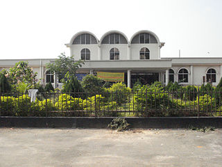
Nawab Faizunnesa Government College (NFGC) is a government college at Laksam, Cumilla, Bangladesh. This college is also known as "Faizunnesa College." As a result of freeing the college from political instability, the college has been recognized as one of the best academic institutions of the upazila.

Khan BahadurNawabSirKazi Golam Mohiuddin Faroqui was a Bengali Muslim Zamindar, politician and minister.

References

  1. "List of Deputy Commissioners". pmis.mopa.gov.bd. Archived from the original on 8 November 2019. Retrieved 2 April 2021.
  2. "কুমিল্লা জেলা". www.comilla.gov.bd.
  3. "কুমিল্লা জেলা". www.comilla.gov.bd.
  4. 1 2 3 4 5 Population and Housing Census 2022 National Report (PDF). Vol. 1. Bangladesh Bureau of Statistics. November 2023.
  5. "Sub-national HDI - Area Database - Global Data Lab". hdi.globaldatalab.org. Retrieved 18 March 2020.
  6. Mahadi Al Hasnat (2 April 2018). "Mixed reactions as govt changes English spellings of 5 district names". Dhaka Tribune. Retrieved 8 April 2018.
  7. 1 2 3 Siddiqi, Mamun (2012). "Comilla District". In Islam, Sirajul; Jamal, Ahmed A. (eds.). Banglapedia: National Encyclopedia of Bangladesh (Second ed.). Asiatic Society of Bangladesh.
  8. Prasad, Bindeshwari (1977). Dynastic History of Magadha. p. 136.
  9. "Gazetteer - Bengal District Gazetteer Tipperah District - South Asia Archive". www.southasiaarchive.com. 1933.
  10. কুমিল্লা জেলা [District background]. Comilla District (in Bengali).
  11. "AL men appointed administrators". The Daily Star. 16 December 2011. Retrieved 19 September 2017.
  12. "Outcry over Comilla DC's misbehaviour with journos". Dhaka Tribune. Retrieved 20 September 2017.
  13. Upazilas of Comilla Archived 24 November 2007 at the Wayback Machine . Bangladesh Government.
  14. 1 2 "Bangladesh Population and Housing Census 2011 Zila Report – Comilla" (PDF). bbs.gov.bd. Bangladesh Bureau of Statistics.
  15. "Census of India, 1941 Volume VI Bengal Province" (PDF).
  16. "Profile Of Zone Comilla | Comilla EPZ". www.bepza.gov.bd. Archived from the original on 20 September 2017. Retrieved 20 September 2017.
  17. "9 new units to start production in Comilla EPZ soon". Dhaka Tribune. Archived from the original on 20 September 2017. Retrieved 20 September 2017.
  18. "Tributes paid at Maynamati War Cemetery". Dhaka Tribune. Retrieved 20 September 2017.
  19. "Choudhurani, Nawab Faizunnesa". Banglapedia. Retrieved 20 September 2017.
  20. "Islam, Kazi Nazrul". Banglapedia. Archived from the original on 6 July 2017. Retrieved 20 September 2017.
  21. "Comilla Zila School". Banglapedia. Retrieved 20 September 2017.
  22. Binswanger-Mkhize, Hans P.; Regt, Jacomina P. de; Spector, Stephen (12 February 2010). Local and Community Driven Development: Moving to Scale in Theory and Practice. World Bank Publications. p. 32. ISBN   9780821381953.
  23. Khan, Saleh Athar (2012). "Ahmad, Khondakar Mostaq". In Islam, Sirajul; Jamal, Ahmed A. (eds.). Banglapedia: National Encyclopedia of Bangladesh (Second ed.). Asiatic Society of Bangladesh.
  24. রবীন্দ্রনাথকে হৃদয়ে ধারণ ও নজরুল চেতনায় উজ্জীবিত হতে হবে. Comillar Kagoj (in Bengali). Archived from the original on 28 February 2019. Retrieved 18 April 2017.
  25. "Life sketch of newly appointed Chief Justice of Bangladesh". Bangladesh Sangbad Sangstha. 23 December 2009. Archived from the original on 4 March 2016.
  26. "Karim, AKM Bazlul". Banglapedia.