Bogra District

Last updated

Bogra District
বগুড়া জেলা
Bogura District
Kherua Mosque.jpg
Sherpur Upazila, Bangladesh - panoramio (3).jpg
Mahasthangar Gokul Medh Bogra Bangladesh (3).JPG
Delta Tower Bogra 02.jpg
Sannasir Vita (Front).jpg
Clockwise from top-left: Kherua Masjid, Fields in Sherpur Upazila, Street in Bogra, Sannasir Vita in Vasu Vihara, Gokul Medh in Mahasthangarh
BD Bogura District locator map.svg
Location of Bogra District in Bangladesh
Bogra District
Expandable map of Bogra District
Coordinates: 24°47′N89°21′E / 24.78°N 89.35°E / 24.78; 89.35
CountryFlag of Bangladesh.svg  Bangladesh
Division Rajshahi Division
Pundravardhana 1280 BC
Government
   Deputy Commissioner Md. Ziaul Hoque
Area
  Total2,899 km2 (1,119 sq mi)
  [1]
Population
 (2022 census) [2]
  Total3,734,300
  Density1,300/km2 (3,300/sq mi)
Time zone UTC+06:00 (BST)
Postal code
5800

Bogra District, officially known as Bogura District, [3] is a district in the northern part of Bangladesh, in the Rajshahi Division. [4] Bogra is an industrial city where many small and mid-sized companies are sited. Bogra was a part of the Pundravardhana territory of ancient Bengal and the ruins of its capital can be found in northern Bogra.

Contents

History

Ancient history

In the ancient period, Bogra District was a part of the territory of the Pundras or Paundras, which were known by the name of Pundravardhana, one of the kingdoms of ancient Bengal region and was separated by the Karatoya River from the more easterly kingdom of Prag-Jyotisha or Kamrupa. The name Pundravardhana frequently occurs in the Mahabharata, Ramayana, and the Puranas. According to the Mahabharata and the Puranas, Vasudeva, a powerful prince of the Pundra family, ruled over Pundravardhana as far back as 1280 B.C.[ citation needed ] The claims of the district to antiquity, however, mostly rely on an association with the old, fortified town that is now known as Mahasthangarh. [5]

The district was under the rule of the Mauryas in the 4th and 3rd centuries B.C. This is evidenced by the presence of pillars of Ashoka in many parts of Pundravardhana and the discovery of an ancient Brahmi inscription at Mahasthangarh in this district. Bhadra Bahu, a high monk of the Jain religion and the son of a Brahmin of Kotivarsha, was the Jain-Guru of Chandra Gupta Maurya. Ashoka was a firm believer in Buddhism and put to death many naked sectarians, presumably the Jains, in Pundravardhana. [5]

The Gupta authority of the third-to-fifth centuries A.D. over this district is revealed by the discovery of several inscriptions of that period from Pundravardhana, which was a Bhukti under the rule of Guptas till the end of the fifth century. [5]

Bogra was the part of Gauda Kingdom of ancient Bengal, after the rule of Guptas in Bengal. At the beginning of the seventh century, King Shashanka came upon the throne of Gauda and exercised his authority over Pundravardhana, including this district. [6] After the death of Shashanka, the region fell under the rule of Harshavardhana (626–647). This is evident from the account of a Chinese pilgrim Xuanzang, who may have visited Pundravardhana in 640 A.D. [6]

Medieval period

By the middle of the eighth century, Gopala I assumed control over the affairs of North Bengal, establishing a royal house known as the Pala Dynasty. After Gopal was elected king, he took his seat in Pundravardhana and ruled over the region up to c.780 and was succeeded by his son Dharmapala (c.781–821). The Pala Kings had peaceful possession of this district until the end of their rule over Bengal in the twelfth century. Dharmapala was the son of and successor to Gopala, extended his power beyond Pundravardhana. Like his father, he was a Buddhist and founded the Buddhist Vihara at Somapura Mahavihara in Varendra, the ruins of which in Naogaon District have been discovered. [6]

The Senas originally came from the Deccan Plateau and settled in West Bengal. Vijayasena was the first ruler of the dynasty. He defeated the last Pala king Madanapala and established his authority over the district. He was succeeded by his son Vallal Sena (1160–1178), who was in possession of the district. He built his capital at Bhabanipur Shaktipeeth, a Shakti Peeth in this district. Lakshmanasena (1178–1204), the son and successor of Vallal Sena, exercised authority over the district until he was driven out by Muhammad bin Bakhtiyar Khalji in 1204. Even after this date, a dynasty of Sena Rajas ruled over the north-eastern tract of this district for nearly a century as feudal chiefs of the Muslim rulers of Bengal. Their capital was at Kamalpur, a few miles to the north of Bhabanipur, a site of pilgrimage for Hindu devotees, and a little to the south of Sherpur Upazila. Achyuta Sena was the last prince of the line. [7]

British Era

The present Bogra District was first formed in 1821 during British rule. In the 1901 census, the population of the district on a reduced area was around 854,533, an increase of 11% over the past decade, and it also revealed there was no town with a population above 10,000. [8] The famous Prafulla Chaki (1888–1908) was born in this district. [9]

Post independence

During the Bangladesh Liberation War of 1971, fighting occurred in the Bogra district during the Battle of Bogra between the allied troops of Mukti Bahini and Indian Army, and the Pakistan Army , with the former being victorious.[ citation needed ]

In 2018, the Government of Bangladesh changed the spelling of the district's name from Bogra to Bogura. [10]

Geography and climate

Formation of land

Karatoa River
BD Korotoa River.JPG
Karatoa River near Mahasthangarh
BD Map Rivers of North Bengal2.jpg
Location
Country Bangladesh
Region Rajshahi Division
City Bogra

The area consisting of Sariakandi Upazila, Gabtali Upazila, Sonatala Upazila, and the majority of Dhunat is called the eastern alluvial tract. It is fertilized by silt from floodwaters. The eastern alluvion is one of the most fertile and prosperous areas in Bogra; jute, aman paddy, sugarcane and pulses are locally grown. Sometimes, as many as three cycles of crops are grown on one field in a year with little diminution in productivity. [11]

The western portion of the district is well-wooded with dense, shrub jungles in Upazilas of Sherpur and in parts of Sibganj, which has a large portion of cultivable wasteland. This part of the district is slightly higher than the eastern parts and is mostly above flood level. The soil of this part is generally suited to the growth of paddy. Adamdighi is well known for the fine qualities of rice, which is also grown to some extent in the Shibganj Upazila. [11]

The tract to the east of the Karatoya is a part of the valley of the Brahmaputra river; it is generally low-lying and intersected by numerous khals (canals, shallow swamps and marshes). It is subject to yearly inundation from the overflow of the Brahmaputra and gets a rich deposit of silt. There is very little jungle and almost the entire area is under cultivation.

Rivers

There are many rivers in the Bogra District. The Karatoya is the central divider of the water channel in the district. The other rivers may be classified into the eastern and western systems. [12] Some of the major rivers in this district are:

Climate

The district has a humid subtropical climate. The average annual rainfall in this part of the country varies from 1400 mm to 1600 mm. [13]

Climate data for Bogra
MonthJanFebMarAprMayJunJulAugSepOctNovDecYear
Mean daily maximum °C (°F)23.0
(73.4)
27.3
(81.1)
32.6
(90.7)
35.1
(95.2)
33.5
(92.3)
32.0
(89.6)
31.4
(88.5)
31.4
(88.5)
31.5
(88.7)
31.0
(87.8)
28.9
(84.0)
25.5
(77.9)
30.3
(86.5)
Daily mean °C (°F)16.4
(61.5)
20.0
(68.0)
25.2
(77.4)
28.8
(83.8)
28.8
(83.8)
28.7
(83.7)
28.7
(83.7)
28.7
(83.7)
28.5
(83.3)
27.1
(80.8)
23.2
(73.8)
19.0
(66.2)
25.3
(77.5)
Mean daily minimum °C (°F)9.8
(49.6)
12.7
(54.9)
17.9
(64.2)
22.5
(72.5)
24.1
(75.4)
25.5
(77.9)
26.1
(79.0)
26.1
(79.0)
25.6
(78.1)
23.2
(73.8)
17.6
(63.7)
12.6
(54.7)
20.3
(68.6)
Average precipitation mm (inches)9
(0.4)
13
(0.5)
21
(0.8)
61
(2.4)
210
(8.3)
326
(12.8)
396
(15.6)
303
(11.9)
257
(10.1)
145
(5.7)
15
(0.6)
6
(0.2)
1,762
(69.3)
Average relative humidity (%)44343645637474747268504657
Source: National newspapers

Demographics

Historical population
YearPop.±% p.a.
1974 1,723,262    
1981 2,108,622+2.93%
1991 2,669,287+2.39%
2001 3,013,056+1.22%
2011 3,400,874+1.22%
2022 3,734,300+0.85%
Sources: [2] [14]

According to the 2022 Census of Bangladesh, Bogra District had 1,025,249 households and a population of 3,734,300, 25.7% of whom lived in urban areas. The population density was 1,288 people per km2. The literacy rate (age 7 and over) was 72.4%, compared to the national average of 74.7%. [2]

Religion in Bogra district (2011) [14]
ReligionPercent
Muslims
93.88%
Hindus
6.04%
Other or not stated
0.08%
Religion in present-day Bogura district [lower-alpha 1]
ReligionPopulation (1941) [15] :92–93Percentage (1941)Population (2011) [14] Percentage (2011)
Islam Star and Crescent.svg 892,62786.21%3,192,72893.88%
Hinduism Om.svg 139,86813.51%205,3336.04%
Others [lower-alpha 2] 2,9680.29%2,8130.08%
Total Population1,035,463100%3,400,874100%

The main language of the district is Bengali; a Northern Bengali dialect is commonly used. [16]

Administration

Upazilas

Bogra has 12 upazilas (subdistricts): [4]

Education

Notable residents

See also

Notes

  1. Bogra district excluding thanas of Joypurhat, Khetlal and Panchbibi thanas
  2. Including Jainism, Christianity, Buddhism, Zoroastrianism, Judaism, Ad-Dharmis, or not stated

Related Research Articles

<span class="mw-page-title-main">Rajshahi Division</span> Division of Bangladesh

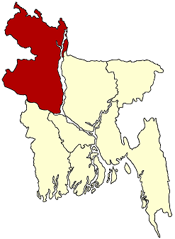
Rajshahi Division is one of the eight first-level administrative divisions of Bangladesh. It has an area of 18,174.4 square kilometres (7,017.2 sq mi) and a population at the 2022 Census of 20,353,119. Rajshahi Division consists of 8 districts, 70 Upazilas and 1,092 Unions.

<span class="mw-page-title-main">Pabna District</span> District of Bangladesh in Rajshahi Division

Pabna District is a district in central Bangladesh. It is an economically important district. Its administrative capital is the eponymous Pabna town.
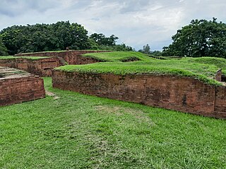
<span class="mw-page-title-main">Mahasthangarh</span> Archaeological site of Bangladesh

Mahasthangarh is one of the earliest urban archaeological sites discovered thus far in Bangladesh. The village Mahasthan in Shibganj upazila of Bogra District contains the remains of an ancient city which was called Pundranagara or Paundravardhanapura in the territory of Pundravardhana. A limestone slab bearing six lines in Prakrit in Brahmi script recording a land grant, discovered in 1931, dates Mahasthangarh to at least the 3rd century BCE. It was an important city under the Maurya Empire. The fortified area was in use until the 8th century CE.

<span class="mw-page-title-main">Bogra</span> City in Rajshahi, Bangladesh

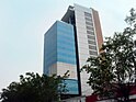
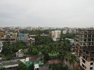
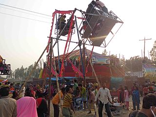
Bogra, officially known as Bogura, is a city located in Bogra District, Rajshahi Division, Bangladesh. The city is a major commercial hub in Northern Bangladesh. It is the second largest city in terms of both area and population in Rajshahi Division. The Bogra bridge connects the Rajshahi Division and Rangpur Division.

<span class="mw-page-title-main">Joypurhat District</span> District of Bangladesh in Rajshahi Division

Joypurhat is a district in the northern part of Bangladesh, part of the Rajshahi Division.

<span class="mw-page-title-main">Sirajganj District</span> District of Bangladesh in Rajshahi Division

Sirajganj District is a district in the North Bengal region of Bangladesh, located in the Rajshahi Division. It is an economically important district of Bangladesh. Sirajganj district is the 25th largest district by area and 9th largest district by population in Bangladesh. It is known as the gateway to North Bengal.

<span class="mw-page-title-main">Sherpur Sadar Upazila</span> Upazila in Mymensingh Division, Bangladesh

Sherpur Sadar is an upazila of Sherpur District in the Division of Mymensingh, Bangladesh.

<span class="mw-page-title-main">Bogra Sadar Upazila</span> Upazila in Rajshahi, Bangladesh

Bogra Sadar Upazila is an upazila of Bogra District in the Division of Rajshahi, Bangladesh. Bogra Thana was established in 1821 and was converted into an upazila in 1983. The upazila takes its name from the district and the Bengali word sadar (headquarters). It is the subdistrict where the district headquarters, Bogra town, is located.

<span class="mw-page-title-main">Dhunat Upazila</span> Upazila in Rajshahi, Bangladesh

Dhunat Upazila is an upazila of Bogra District in the Division of Rajshahi, Bangladesh.

<span class="mw-page-title-main">Sherpur Upazila</span> Upazila in Rajshahi, Bangladesh

Sherpur Upazila is an upazila of Bogra District in the Division of Rajshahi, Bangladesh. Sherpur Thana was established in 1962 and was converted into an upazila in 1983. It is named after its administrative center, the town of Sherpur. It is said that there once lived Sher family in the vicinity, from which the name "Sherpur" evolved.

<span class="mw-page-title-main">Shibganj Upazila, Bogra</span> Upazila in Rajshahi, Bangladesh

Shibganj Upazila is an upazila of Bogra District in the Division of Rajshahi, Bangladesh. The upazila was created in 1983. It is named after its administrative center, the town of Shibganj.

<span class="mw-page-title-main">Ullahpara Upazila</span> Upazila in Rajshahi, Bangladesh

Ullapara is an upazila, or sub-district of Sirajganj District, located in Rajshahi Division, Bangladesh.
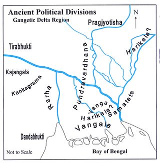
<span class="mw-page-title-main">Bangali River</span> River in Bangladesh

The Bangali River is one of the main rivers in northern Bangladesh. As of 2007, the river is in the news because of the possibility that it might merge with the Jamuna River, which could lead to major changes in the geography of the region.

<span class="mw-page-title-main">Karatoya River</span> River in Rajshahi, India and Bangladesh

Karatoya River is a small stream in Rajshahi Division of Bangladesh.

<span class="mw-page-title-main">Pundravardhana</span> Ancient Indian kingdom

Pundravardhana or Pundra Kingdom, was an ancient kingdom of Iron Age South Asia located in the Bengal region of the Indian subcontinent with a territory that included parts of present-day Rajshahi, Rangpur and Dhaka Divisions of Bangladesh as well as the West Dinajpur district of West Bengal, India. The capital of the kingdom, then known as Pundranagara, was located at Mahasthangarh in Bogra District of northern Bangladesh.

<span class="mw-page-title-main">Varendra</span> Region in northern Bengal

Varendra, also known as Barind, was an ancient and historical territory of Northern Bengal, now mostly in Bangladesh and a little portion in the Indian state of West Bengal.

<span class="mw-page-title-main">Shajahanpur Upazila</span> Upazila in Rajshahi Division, Bangladesh

Shajahanpur Upazila is an upazila of Bogra District in the Division of Rajshahi, Bangladesh. Created in 2003, it is the newest upazila in the District.

<span class="mw-page-title-main">Sultan Balkhi</span>

Hazrat Ibrahim Shah Sultan Balkhi (Rahmatullah Alaih) (Bengali: শাহ সুলতান বলখী, Persian: شاه سلطان بلخی), also known by his sobriquet, Mahisawar (Bengali: মাহিসওয়ার, Persian: ماهی سوار, romanized: Mâhi-Savâr, lit. 'Fish-rider'), was a 16th-century Muslim saint. He is associated with the spread of Islam in Sandwip and Bogra.

Kazipur River flows through Kazipur Upazila in Sirajganj District, Bangladesh. It then flows south and joins the Ichamati River.

Nagar River begins in the Bogra District of Bangladesh and ends in Natore District.

References

  1. "District Statistics 2011: Bogra" (PDF). Bangladesh Bureau of Statistics. Archived from the original (PDF) on 23 July 2014. Retrieved 14 July 2014.
  2. 1 2 3 Population and Housing Census 2022: Preliminary Report. Bangladesh Bureau of Statistics. August 2022. pp. viii, 28, 30, 39, 44, 46. ISBN   978-984-35-2977-0.
  3. Mahadi Al Hasnat (2 April 2018). "Mixed reactions as govt changes English spellings of 5 district names". Dhaka Tribune. Retrieved 8 April 2018.
  4. 1 2 Md Nazmul Haq (2012). "Bogra District". In Sirajul Islam and Ahmed A. Jamal (ed.). Banglapedia: National Encyclopedia of Bangladesh (Second ed.). Asiatic Society of Bangladesh.
  5. 1 2 3 Bangladesh District Gazetteers:Bogra. Government of Bangladesh. 1979, pp. 27
  6. 1 2 3 Bangladesh District Gazetteers:Bogra. Government of Bangladesh. 1979, pp. 27–28
  7. Bangladesh District Gazetteers:Bogra. Government of Bangladesh. 1979, p. 28
  8. Bogra – Encyclopædia Britannica article
  9. "Chaki, Prafulla". Banglapedia. Retrieved 11 January 2020.
  10. "English spelling of five districts changed". New Age. Dhaka. 2 April 2018. Retrieved 3 April 2018.
  11. 1 2 Bangladesh District Gazetteers:Bogra. Government of Bangladesh. 1979, p. 81
  12. Bangladesh District Gazetteers:Bogra. Government of Bangladesh. 1979, pp. 2–8
  13. "Climatic Variability and Coping with Drought in North Western Region of Bangladesh: An Empirical Study". June 2014. Archived from the original on 21 January 2022.
  14. 1 2 3 "Bangladesh Population and Housing Census 2011 Zila Report – Bogra" (PDF). Bangladesh Bureau of Statistics .
  15. "Census of India, 1941 Volume VI Bengal Province" (PDF).
  16. Bangladesh District Gazetteers:Bogra. Government of Bangladesh. 1979, pp. 217–219
  17. "AL men appointed administrators". The Daily Star. 15 December 2011. Retrieved 7 April 2016.
  18. Ali, Syed Hamde (20 October 2009). "Mohammed Ali of Bogra". The Daily Star. Archived from the original on 4 February 2015. Retrieved 1 April 2015.
  19. Md. Muktadir Arif Mozammel (2012). "Chaki, Prafulla". In Sirajul Islam and Ahmed A. Jamal (ed.). Banglapedia: National Encyclopedia of Bangladesh (Second ed.). Asiatic Society of Bangladesh.
  20. Akbar, Md. Ali (2012). "Chowdhury, Mafiz Ali". In Islam, Sirajul; Jamal, Ahmed A. (eds.). Banglapedia: National Encyclopedia of Bangladesh (Second ed.). Asiatic Society of Bangladesh.
  21. Kamol, Ershad (2 August 2008). "A filmmaker's affinity for literature and Rabindra Sangeet". The Daily Star.
  22. "Bangladesh: MR Akhtar Mukul passes away". The Daily Star . 27 June 2004. Archived from the original on 7 March 2012. Retrieved 20 November 2010.
  23. Emajuddin, Ahamed (2012). "Rahman, Shahid Ziaur". In Islam, Sirajul; Jamal, Ahmed A. (eds.). Banglapedia: National Encyclopedia of Bangladesh (Second ed.). Asiatic Society of Bangladesh.
  24. "Parliament Election Result of 1991,1996,2001 Bangladesh Election Information and Statistics". Vote Monitor Networks. Archived from the original on 28 December 2008. Retrieved 1 April 2015.