"},"area_total_km2":{"wt":"408.50"},"area_metro_km2":{"wt":""},"elevation_m":{"wt":""},"elevation_ft":{"wt":""},"population_footnotes":{"wt":"{{Cite book |url=https://bbs.portal.gov.bd/sites/default/files/files/bbs.portal.gov.bd/page/b343a8b4_956b_45ca_872f_4cf9b2f1a6e0/2024-01-31-15-51-b53c55dd692233ae401ba013060b9cbb.pdf |title=National Report |date=November 2023 |publisher=[[Bangladesh Bureau of Statistics]] |isbn=978-9844752016 |series=Population and Housing Census 2022 |volume=1 |location=Dhaka |pages=401}}"},"population_total":{"wt":"276199"},"population_as_of":{"wt":"[[2022 Bangladeshi census|2022]]"},"population_density_km2":{"wt":"auto"},"leader_title":{"wt":"M.P"},"leader_name":{"wt":"Abdul Mannan"},"leader_title1":{"wt":"Bogra-1. p- 36"},"leader_name1":{"wt":""},"timezone":{"wt":"[[Bangladesh Standard Time|BST]]"},"utc_offset":{"wt":"+6"},"postal_code_type":{"wt":"[[List of postal codes in Bangladesh|Postal code]]"},"postal_code":{"wt":"5830{{Cite web |url=https://bdpost.portal.gov.bd/site/page/4694b7b6-0cab-4172-9fc7-dbc949f62841 |title=Bangladesh Postal Code |date=21 October 2024 |publisher=Bangladesh Postal Department under the Department of Posts and Telecommunications of the Ministry of Posts, Telecommunications and Information Technology of the People's Republic of Bangladesh |location=Dhaka}}"},"area_code":{"wt":"05028{{Cite web |url=https://en.chahaoba.com/Bangladesh |title=Bangladesh Area Code |date=18 October 2024 |publisher=Chahaoba.com |location=China}}"},"website":{"wt":"{{URL|http://shariakandi.bogra.gov.bd/}}{{in lang|bn}}"},"footnotes":{"wt":""}},"i":0}}]}" id="mwAg">Upazila in Rajshahi, Bangladesh
Sariakandi সারিয়াকান্দি | |
---|---|
![]() Kalitola Groyen Badh on the bank of Jamuna river. | |
![]() | |
Coordinates: 24°53′N89°34′E / 24.883°N 89.567°E | |
Country | ![]() |
Division | Rajshahi |
District | Bogra |
Government | |
• M.P | Abdul Mannan |
Area | |
• Total | 408.50 km2 (157.72 sq mi) |
Population | |
• Total | 276,199 |
• Density | 680/km2 (1,800/sq mi) |
Time zone | UTC+6 (BST) |
Postal code | 5830 [3] |
Area code | 05028 [4] |
Website | shariakandi |
Sariakandi Upazila (Bengali : সারিয়াকান্দি উপজেলা) is an upazila of Bogra District in the Division of Rajshahi, Bangladesh. Sariakandi Thana was established in 1886 and was converted into an upazila in 1983. [5] It is named after its administrative center, the town of Sariakandi.
Sariakandi Upazila has a total area of 432.55 square kilometres (167.01 sq mi). About three-fifths is land and two-fifths is water, chiefly the Jamuna River, which flows south through the upazila. [1] It is the easternmost upazila of Bogra District. It borders Sonatala Upazila to the west and north, Fulchhari Upazila of Gaibandha District to the north, Islampur, Madarganj and Sarishabari upazilas of Jamalpur District to the east, Kazipur upazila of Sirajganj District to the southeast, Dhunat Upazila to the south, and Gabtali Upazila to the west. [5] [6]
Year | Pop. (000) | ±% |
---|---|---|
1981 | 199 | — |
1991 | 230 | +15.6% |
2001 | 240 | +4.3% |
2011 | 271 | +12.9% |
2022 | 276 | +1.8% |
Source: Bangladesh Bureau of Statistics [1] |
According to the 2011 Census of Bangladesh, Sariakandi Upazila had 75,614 households and a population of 270,719. 66,938 (24.73%) were under 10 years of age. Sariakandi had a literacy rate (age 7 and over) of 36.94%, compared to the national average of 51.8%, and a sex ratio of 1001 females per 1000 males. 18,543 (6.85%) lived in urban areas. [1] [8]
Sariakandi Upazila is divided into Sariakandi Municipality and 12 union parishads: Bhelabari, Bohail, Chaluabari, Chandan Baisha, Fulbari, Hat Sherpur, Kamalpur, Karnibari, Kazla, Kutubpur, Narchi, and Sariakandi. The union parishads are subdivided into 100 mauzas and 173 villages.
Sariakandi Municipality is subdivided into 9 wards and 17 mahallas. [1]
There are five colleges in the upazila. They include Chandan Baisha Degree College, founded in 1964, Chhaihata Degree College, and Shariakandi Degree College.
Jamthol Technical Management College, founded in 2001, is one of the upazila's two colleges in the technical and vocational education system. [5]
The madrasa education system includes three fazil madrasas. [9]
Anushilon pre-cadet & high school founded in 2000 is one of the best kindergarten school for its curiculam, activities & result.
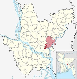
Raipur is an upazila in Lakshmipur District, Chittagong Division, Bangladesh. It is surrounded by the upazilas of Faridganj, Ramganj, Lakshmipur Sadar, Mehendiganj and Haimchar, and on the west by the Meghna River. Raipur has 40,618 households, and covers an area of 201.32 square kilometres (77.73 sq mi).
Melandaha is an upazila of Jamalpur District in the Division of Mymensingh, Bangladesh.
Narayanganj Sadar is an upazila of Narayanganj District in the Division of Dhaka, Bangladesh.
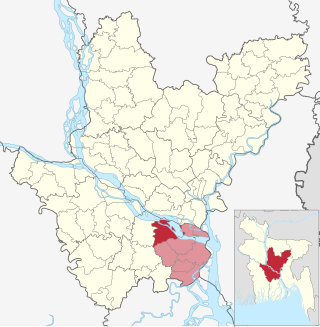
Damudya is an upazila of Shariatpur District in the Division of Dhaka, Bangladesh. Damudya Thana was established in 1975 and upgraded to an upazila in 1982. It was named after its administrative center, the town of Damudya.
Shariatpur Sadar is an upazila of Shariatpur District in the Division of Dhaka, Bangladesh. Shariatpur Thana was converted into an upazila in 1984. It is the subdistrict where the district headquarters, Shariatpur town, is located.
Jhenidah Sadar is an upazila of Jhenaidah District in the Division of Khulna, Bangladesh.
Kotchandpur is an upazila of Jhenaidah District in Khulna Division, in south-west Bangladesh.
Maheshpur Upazila is a part of Jhenaidah District in the Khulna Division of Bangladesh.
Adamdighi Upazila is an upazila of Bogra District in the Division of Rajshahi, Bangladesh. Adamdighi Thana was established in 1821 and was converted into an upazila in 1983. It is named after its administrative center, the town of Adamdighi. Local legend has it that its name came from a Muslim saint, Baba Adam, who visited and dug a dighi (tank) for water storage.
Bogra Sadar Upazila officially Bogura Sadar Upazila is an upazila of Bogra District in the Division of Rajshahi, Bangladesh. Bogra Thana was established in 1821 and was converted into an upazila in 1983. The upazila takes its name from the district and the Bengali word sadar (headquarters). It is the subdistrict where the district headquarters, Bogra town, is located.
Dhunat Upazila is an upazila of Bogra District in the Division of Rajshahi, Bangladesh.
Dhupchanchia Upazila is an upazila of Bogra District in the Division of Rajshahi, Bangladesh. Dhupchanchia Thana was established in 1880 and was converted into an upazila in 1983. It is named after its administrative center, the town of Dhupchanchia.
Gabtali is an upazila of the Bogra District, located in Bangladesh's Rajshahi Division. It is named after its administrative centre, the town of Gabtali and is best known as the home upazila of Ziaur Rahman, the late President of Bangladesh. Gabtali town is 7 km north of Bogra.
Kahaloo Upazila is an upazila of Bogra District in the Division of Rajshahi, Bangladesh. Kahaloo Thana was established in 1928 and was converted into an upazila in 1983. It is named after its administrative center, the town of Kahaloo.
Nandigram Upazila is an upazila of Bogra District in the Division of Rajshahi, Bangladesh. Nandigram Thana was established in 1932 and was converted into an upazila in 1983. It is named after its administrative center, the town of Nandigram.
Shibganj Upazila is an upazila of Bogra District in the Division of Rajshahi, Bangladesh. The upazila was created in 1983. It is named after its administrative center, the town of Shibganj.
Sonatala Upazila is an upazila of Bogra District in the Division of Rajshahi, Bangladesh. Sonatala Thana was established in 1981 from Sariakandi Thana and was converted into an upazila in 1984. It is named after its administrative center, the town of Sonatala.
Saghata is an upazila of Gaibandha District in the Division of Rangpur, Bangladesh.
Belkuchi is an upazila, or sub-district of Sirajganj District, located in Rajshahi Division, Bangladesh.
Zajira is an upazila of Shariatpur District in the Division of Dhaka, Bangladesh. Zajira Thana was established in 1973 and was upgraded to an upazila in 1984. It was named after its administrative center, the town of Zajira.