"},"area_total_km2":{"wt":"247.43"},"area_metro_km2":{"wt":""},"elevation_m":{"wt":""},"elevation_ft":{"wt":""},"population_footnotes":{"wt":"{{Cite book |url=https://bbs.portal.gov.bd/sites/default/files/files/bbs.portal.gov.bd/page/b343a8b4_956b_45ca_872f_4cf9b2f1a6e0/2024-01-31-15-51-b53c55dd692233ae401ba013060b9cbb.pdf |title=National Report |date=November 2023 |publisher=[[Bangladesh Bureau of Statistics]] |isbn=978-9844752016 |series=Population and Housing Census 2022 |volume=1 |location=Dhaka |pages=401}}"},"population_total":{"wt":"307521"},"population_as_of":{"wt":"[[2022 Bangladeshi census|2022]]"},"population_density_km2":{"wt":"auto"},"leader_title":{"wt":""},"leader_name":{"wt":""},"leader_title1":{"wt":""},"leader_name1":{"wt":""},"timezone":{"wt":"[[Bangladesh Standard Time|BST]]"},"utc_offset":{"wt":"+6"},"postal_code_type":{"wt":"[[List of postal codes in Bangladesh|Postal code]]"},"postal_code":{"wt":"5850{{Cite web |url=https://bdpost.portal.gov.bd/site/page/4694b7b6-0cab-4172-9fc7-dbc949f62841 |title=Bangladesh Postal Code |date=21 October 2024 |publisher=Bangladesh Postal Department under the Department of Posts and Telecommunications of the Ministry of Posts, Telecommunications and Information Technology of the People's Republic of Bangladesh |location=Dhaka}}"},"area_code":{"wt":"05023{{Cite web |url=https://en.chahaoba.com/Bangladesh |title=Bangladesh Area Code |date=18 October 2024 |publisher=Chahaoba.com |location=China}}"},"website":{"wt":"{{URL|http://dhunot.bogra.gov.bd/}}{{in lang|bn}}"},"footnotes":{"wt":""}},"i":0}}]}" id="mwAg">Upazila in Rajshahi, Bangladesh
Dhunat ধুনট | |
---|---|
![]() Jamuna River in Dhunat Upazila | |
![]() | |
Coordinates: 24°41′N89°32′E / 24.683°N 89.533°E | |
Country | ![]() |
Division | Rajshahi |
District | Bogra |
Area | |
• Total | 247.43 km2 (95.53 sq mi) |
Population | |
• Total | 307,521 |
• Density | 1,200/km2 (3,200/sq mi) |
Time zone | UTC+6 (BST) |
Postal code | 5850 [3] |
Area code | 05023 [4] |
Website | dhunot |
Dhunat Upazila (Bengali : ধুনট উপজেলা) is an upazila of Bogra District in the Division of Rajshahi, Bangladesh.
Dhunat Thana was established in 1962 and was converted into an upazila in 1983. [5] It is named after its administrative center, the town of Dhunat, which became a municipality in 2001. By 2006 Dhunat Municipality had achieved 100% sanitation and it was awarded as the 2nd pourashava among the country.[ citation needed ]
Dhunat Upazila has a total area of 247.43 square kilometres (95.53 sq mi). [1] It lies on the west bank of the Jamuna River. It borders Gabtali and Sariakandi upazilas to the north, Sirajganj District to the east and south, and Sherpur and Shajahanpur upazilas to the west. [5]
Year | Pop. (000) | ±% |
---|---|---|
1981 | 213 | — |
1991 | 247 | +16.0% |
2001 | 271 | +9.7% |
2011 | 292 | +7.7% |
2022 | 308 | +5.5% |
Source: Bangladesh Bureau of Statistics [1] |
According to the 2011 Census of Bangladesh, Dhunat Upazila had 74,897 households and a population of 292,404. 67,775 (23.18%) were under 10 years of age. Dhunat had a literacy rate (age 7 and over) of 35.64%, compared to the national average of 51.8%, and a sex ratio of 1043 females per 1000 males. 22,673 (7.75%) lived in urban areas. [1] [7]
Dhunat Upazila is divided into Dhunat Municipality and 10 union parishads: Kalerpara, Bhandarbari, Chaukibari, Chikashi, Dhunat, Elangi, Gopalnagar, Gosainbari, Mathurapur, and Nimgachhi. The union parishads are subdivided into 90 mauzas and 207 villages.
Chairman :Md. Abdul Hi Khokon
Vice Chairman :Md.Mohosin Alom
Women Vice Chairman :Popi Rani Saha
Upazila Nirbahi Officer (UNO): Rajia Sultana [8]
Dhunat Municipality is subdivided into 9 wards and 16 mahallas. [1]
There are 10 colleges in the upazila. They include Dhunat Mohila College, founded in 1996, Jalsuka Habibur Rahman Degree College, G.M.C Degree College, Goshai Bari Degree College, and Sonahata College. Dhunat Degree College, founded in 1972, is the only honors level college in the upazila. [5]
According to Banglapedia, Panchthupi Nasratpur Jaher Ali High School, Dhunat High School, founded in 1941, is a notable secondary school and another Dhunat Adarsh High School, founded in 1988. [5]
The madrasa education system includes three fazil madrasas. [9] According to Banglapedia, Jorkhali Senior Madrasa, founded in 1911, is a notable one. [5]
Patiya is an upazila of Chattogram District in Chattogram Division, Bangladesh.
Bhanga is an upazila of Faridpur District in the Division of Dhaka, Bangladesh.
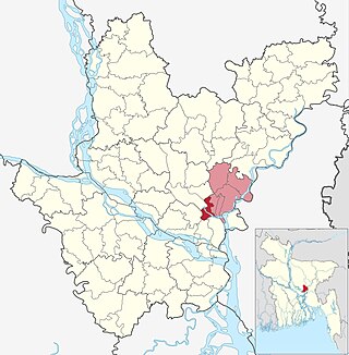
Narayanganj Sadar is an upazila of Narayanganj District in the Division of Dhaka, Bangladesh.
Narsingdi Sadar is an upazila of Narsingdi District in the Division of Dhaka, Bangladesh.
Jhenidah Sadar is an upazila of Jhenaidah District in the Division of Khulna, Bangladesh.
Kotchandpur is an upazila of Jhenaidah District in Khulna Division, in south-west Bangladesh.
Adamdighi Upazila is an upazila of Bogra District in the Division of Rajshahi, Bangladesh. Adamdighi Thana was established in 1821 and was converted into an upazila in 1983. It is named after its administrative center, the town of Adamdighi. Local legend has it that its name came from a Muslim saint, Baba Adam, who visited and dug a dighi (tank) for water storage.
Bogra Sadar Upazila is an upazila of Bogra District in the Division of Rajshahi, Bangladesh. Bogra Thana was established in 1821 and was converted into an upazila in 1983. The upazila takes its name from the district and the Bengali word sadar (headquarters). It is the subdistrict where the district headquarters, Bogra town, is located.
Dhupchanchia Upazila is an upazila of Bogra District in the Division of Rajshahi, Bangladesh. Dhupchanchia Thana was established in 1880 and was converted into an upazila in 1983. It is named after its administrative center, the town of Dhupchanchia.
Gabtali is an upazila of the Bogra District, located in Bangladesh's Rajshahi Division. It is named after its administrative centre, the town of Gabtali and is best known as the home upazila of Ziaur Rahman, the late President of Bangladesh. Gabtali town is 7 km north of Bogra.
Kahaloo Upazila is an upazila of Bogra District in the Division of Rajshahi, Bangladesh. Kahaloo Thana was established in 1928 and was converted into an upazila in 1983. It is named after its administrative center, the town of Kahaloo.
Nandigram Upazila is an upazila of Bogra District in the Division of Rajshahi, Bangladesh. Nandigram Thana was established in 1932 and was converted into an upazila in 1983. It is named after its administrative center, the town of Nandigram.
Sariakandi Upazila is an upazila of Bogra District in the Division of Rajshahi, Bangladesh. Sariakandi Thana was established in 1886 and was converted into an upazila in 1983. It is named after its administrative center, the town of Sariakandi.
Sherpur Upazila is an upazila of Bogra District in the Division of Rajshahi, Bangladesh. Sherpur Thana was established in 1962 and was converted into an upazila in 1983. It is named after its administrative center, the town of Sherpur. It is said that there once lived Sher family in the vicinity, from which the name "Sherpur" evolved.
Shibganj Upazila is an upazila of Bogra District in the Division of Rajshahi, Bangladesh. The upazila was created in 1983. It is named after its administrative center, the town of Shibganj.
Sonatala Upazila is an upazila of Bogra District in the Division of Rajshahi, Bangladesh. Sonatala Thana was established in 1981 from Sariakandi Thana and was converted into an upazila in 1984. It is named after its administrative center, the town of Sonatala.
Dimla is an upazila of Nilphamari District in the Rangpur Division, Bangladesh. It is the oldest thana of Nilphamari region.
Chatmohar is an upazila of Pabna District in the Division of Rajshahi, Bangladesh.
Santhia is an upazila of Pabna District in the Division of Rajshahi, Bangladesh.
Shajahanpur Upazila is an upazila of Bogra District in the Division of Rajshahi, Bangladesh. Created in 2003, it is the newest upazila in the District.