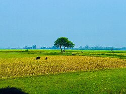
Tarash তাড়াশ | |
---|---|
Coordinates: 24°26′N89°22.5′E / 24.433°N 89.3750°E | |
Country | Bangladesh |
Division | Rajshahi |
District | Sirajganj |
Area | |
• Total | 300.07 km2 (115.86 sq mi) |
Population | |
• Total | 211,853 |
• Density | 710/km2 (1,800/sq mi) |
Time zone | UTC+6 (BST) |
Postal code | 6770 [2] |
Area code | 07528 [3] |
Website | Official Map of Tarash |
Tarash [lower-alpha 1] is an upazila, or sub-district of Sirajganj District, located in Rajshahi Division, Bangladesh. [4]
Tarash is located at 24°26′00″N89°22′30″E / 24.4333°N 89.3750°E . It has 48,941 households and total area 300.07 km2. The upazila is bounded by Sherpur upazila of Bogra district on the north, Bhangura and Chatmohar upazilas of Pabna district on the south, Raiganj and Ullahpara upazilas on the east, Gurudaspur and Singra upazilas of Natore district on the west. [5]
According to the 2011 Census of Bangladesh, Tarash Upazila had 48,941 households and a population of 197,214. 46,610 (23.63%) were under 10 years of age. Tarash had a literacy rate (age 7 and over) of 38.98%, compared to the national average of 51.8%, and a sex ratio of 1024 females per 1000 males. 8,442 (4.28%) lived in urban areas. [7] Ethnic population was 9,498 (4.82%), mainly Oraon and Mahato. [8]
As of the 1991 Bangladesh census, Tarash has a population of 135435. Males constitute are 50.21% of the population, and females 49.79%. This Upazila's eighteen up population is 68421. Tarash has an average literacy rate of 22.6% (7+ years), and the national average of 32.4% literate. [9]
Tarash, primarily formed as a Thana, was turned into an upazila in 1983. [5]
Tarash Upazila is divided into Tarash Municipality and eight union parishads:Talam, Baruhas, Deshigram, Madhainagar, Magura Binod, Naogaon, Saguna, and Tarash. The union parishads are subdivided into 171 mauzas and 254 villages. [7]
Muradnagar is an upazila of the Comilla District in Chittagong Division, Bangladesh.
Belaichhari is an upazila of Rangamati District in the division of Chittagong, Bangladesh.
Sarishabari is an upazila of Jamalpur District in the Division of Mymensingh, Bangladesh.
Sarankhola is an upazila of Bagerhat District in the Division of Khulna, Bangladesh. Sarankhola was formed as a Thana in 1907. A major part of the upazila belongs to the Sundarbans.
Mirpur (Bengali: মিরপুর is an upazila of Kushtia District in the Division of Khulna, Bangladesh. Mirpur Thana was formed in 1885 and it was turned into an upazila in 1983.
Shyamnagar is an upazila of Satkhira District in the Division of Khulna, Bangladesh. It is the biggest upazila of Bangladesh. It is close to the Sundarbans.
Tala is an upazila of the Satkhira District in the Khulna Division of Bangladesh.
Dhunat Upazila is an upazila of Bogra District in the Division of Rajshahi, Bangladesh.
Rowmari is an upazila of Kurigram District in the Division of Rangpur, Bangladesh.
Raninagar is an Upazila of Naogaon District in the Division of Rajshahi, Bangladesh.
Gurudaspur is an upazila of Natore District in the Division of Rajshahi, Bangladesh.
Singra is an upazila of Natore District in the Division of Rajshahi, Bangladesh.
Kishoreganj is an upazila of Nilphamari District in the Division of Rangpur, Bangladesh.
Belkuchi is an upazila, or sub-district of Sirajganj District, located in Rajshahi Division, Bangladesh.
Chauhali is an upazila, or sub-district of Sirajganj District, located in Rajshahi Division, Bangladesh.
Kamarkhanda is an upazila, or sub-district of Sirajganj District, located in Rajshahi Division, Bangladesh.
Kazipur is an upazila, or sub-district of Sirajganj District, located in Rajshahi Division, Bangladesh.
Raiganj is an upazila, or sub-district of Sirajganj District, located in Rajshahi Division, Bangladesh.
Sirajganj Sadar is an upazila, or sub-district of Sirajganj District, located in Rajshahi Division, Bangladesh.
Ullapara is an upazila, or sub-district of Sirajganj District, located in Rajshahi Division, Bangladesh.