Ambalappuzha is a small town in the Alappuzha district of Kerala state, India. It is located 14 km (8.7 mi) south of Alappuzha which is the district headquarters.
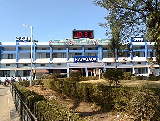
Rayagada is a municipality in Rayagada district in the Indian state of Odisha. It is the administrative headquarters of Rayagada district.
Badharghat is a census town in West Tripura district in the state of Tripura, India.
Belonia is a town and municipal council in South Tripura district, Tripura, India. It is also the headquarters of South Tripura District. It is linked with Agartala by National Highway 108A from Belonia to Jolaibari and via National Highway 8 from Jolaibari to Agartala. Belonia lies on the border with Bangladesh.
Calangute is a town in the North Goa district of the Indian state of Goa. It is famous for its beach, the largest in North Goa and a popular tourist destination. The peak tourist season is during Christmas and New Year, and during the summer in May. During the monsoon season, from June through September, the sea can be rough and swimming is prohibited. The beach offers water sport activities like parasailing and water skiing, among others.
Kamalpur is a town and a Nagar Panchayat in Dhalai District in the Indian state of Tripura around 93 km from the state capital Agartala. It is the largest Sub-divisional town in Dhalai District.
Kanhirode is a census town in Kannur district of Kerala state, India. Kanhirode is located 13 km east of Kannur city on Kannur-Mattanur road.
Natrampalli is a selection grade panchayat town and Taluk in Tirupattur district in the Indian state of Tamil Nadu. The Natrampalli block is a revenue block in the Tirupattur district of Tamil Nadu, India.
Nimapada is a town and a Notified Area Council (NAC) in Puri district on the way to Konark and 40 km from the state capital Bhubaneswar in the Indian state of Odisha.
Sabroom is a town and a Nagar Panchayat in South Tripura district in the Indian state of Tripura. It is located on the banks of the Feni River, which separates India and Bangladesh. It is believed that during the Bangladesh War of Independence in 1971, the Hindu society people migrated to Sabroom from Noakhali and Feni districts of Bangladesh.
Teliamura is a town and a Municipal Council in Khowai district in the Indian state of Tripura. It is on National Highway No. 08 of India. It is also the headquarters of the recently included sub-division of Teliamura. It is 45 km from Agartala, Capital of Tripura, 35 km from Khowai and 42 km from Ambassa.
Thiruporur is a panchayat town in Chengalpattu district in the Indian state of Tamil Nadu. The Thiruporur Kandaswamy temple is situated in the center of the town. There is a large temple tank in the vicinity of the temple. Thiruporur is located on Old Mahabalipuram Road and is flanked by Kelambakkam on one side and Alathur Pharmaceutical Industrial Estate on the other side, both of which are also on Old Mahabalipuram Road.

Udma is a census town in Kasaragod district in the Indian state of Kerala.
Pratapgarh is a census town in West Tripura district in the Indian state of Tripura.
Keezhallur is a census town in Kannur district in the Indian state of Kerala.

Sipahijala District is a district of Tripura, India. This district was created in January 2012 when four new districts were established in Tripura, taking the number of districts in the state from four to eight. Part of the district was formed from the former district of West Tripura. The principal towns in the district are Bishalgarh, Bishramganj, Melaghar and Sonamura.
Gandhigram is a town in Tripura, India. located around 10 km from city centre Agartala. It comes under Sadar district. It has an old age home called Sandhyoneer.

Melaghar is a small town located in the Indian state of Tripura and a Municipal Council in Sipahijala district, situated about 50 km from the capital Agartala. It is a neighbour to Sonamura and 10 km away from the Bangladesh International border. Neermahal is a famous tourist attraction in the town, situated in the middle of Rudrasagar Lake.
Santirbazar is a town and Municipal Council in South Tripura district, Tripura, India located 84 kms away from state capital Agartala. It is linked with Agartala by National Highway 8 via Udaipur and Bishramganj to Sabroom.

Sonamura is one of the 60 Legislative Assembly constituencies of Tripura state in India. It is in Sipahijala district and a part of West Tripura Lok Sabha constituency.