Selayar Islands Regency

Last updated

Selayar Islands Regency
Kabupaten Kepulauan Selayar
Logo Kabupaten Kepulauan Selayar.png
Nickname: 
Tanadoang
Motto: 
Selayar Mapan Mandiri
Locator Selayar Regency.svg
Location within South Sulawesi
Sulawesi location map plain.svg
Red pog.svg
Selayar Islands Regency
Location in Sulawesi and Indonesia
Indonesia location map.svg
Red pog.svg
Selayar Islands Regency
Selayar Islands Regency (Indonesia)
Coordinates: 6°49′00″S120°48′00″E / 6.81667°S 120.8°E / -6.81667; 120.8
Country Indonesia
Region Sulawesi
Province South Sulawesi
Anniversary29 November 1605;418 years ago (1605-11-29)
Capital Benteng
Government
  RegentMuh Basli Ali
  Vice RegentZainuddin
Area
  Total1,357.03 km2 (523.95 sq mi)
Population
 (mid 2023 estimate [1] )
  Total142,100
  Density100/km2 (270/sq mi)
Time zone UTC+8 (ICST)
Postcode
92812
Area code (+62) 414
Vehicle registration DD
Website kepulauanselayarkab.go.id

The Selayar Islands Regency is a regency of Indonesia in South Sulawesi province that covers the Selayar Islands, which lie southeast of the southern peninsula of Sulawesi. The archipelago consists of the group's main island (Selayar Island), which is surrounded by 41 smaller islands around its coast; further to the southeast lies a widespread group of islands, including the smaller but still substantial islands of Pasimassunggu, Pasimarannu and Pasilambena in the far south, and the huge atoll of Takabonerate (itself containing 28 named islands). The regency covers an area of 1,357.03 km2, and had a population of 103,596 at the 2000 Census, 122,055 at the Census of 2010 [2] and 137,071 at that of 2020. [3] The official estimate for mid 2023 was 142,100 (comprising 69,907 males and 72,193 females). [1] The administrative centre is the town of Benteng on Selayar Island. The Selayar Straits separate the regency from Sulawesi island.

Contents

Administration

Administrative Districts

The Selayar Islands Regency is divided into eleven districts (kecamatan), tabulated below with their populations at the 2010 Census [2] and the 2020 Census, [3] together with the official estimates for mid 2023. [1] The table also includes the locations of the administrative centres ('capitals') of the districts, the numbers of villages (a total of 81 rural desa and 7 urban kelurahan) and named islands within each district, and its post code(s).

Kode
Wilayah
Name of
District
(kecamatan)
Area
in
km2
Pop'n
Census
2010
Pop'n
Census
2020
Pop'n
Estimate
mid 2023
Admin
centre
No.
of
villages
No.
of
islands
Post
code(s)
73.01.07Pasimarannu195.338,95910,49210,915Bonerate8992862
73.01.09Pasilambena114.886,7868,0058,578Kalaotoa61392863
73.01.06Pasimassunggu131.807,6258,6389,261Kembang Ragi72192861 (a)
73.01.08 Taka Bonerate (b)49.3012,29613,48414,774Batang91792860
73.01.10Pasimassunggu Timur
(East Pasimassunggu)
67.147,3077,8668,099Bontobulaeng6292861
Southern sector(c)558.4542,97348,48551,6273662
73.01.05Bontosikuyu248.2214,33215,30316,030Harapan122192855
73.01.02Bontoharu (d)128.1212,48414,60815,325Bontobangun8 (e)492811
73.01.01 Benteng (town)24.6321,34424,84924,514Benteng3 (f)-92812
73.01.04Bontomanai136.4212,22613,70314,119Polebungin10-92851
73.01.11Buki68.146,1256,7426,920Buki7-92851
- 92854
73.01.03Bontomatene (g)193.0512,57113,38113,565Batangmata12 (h)592854
Selayar Island sector(i)798.5879,08288,58690,4735230

Notes: (a) except the desa of Bontosaile, which has a postcode of 92811. (b) Taka Bonerate District includes the atoll of that name, together with Kayuadi Island to its west.
(c) in the south of the regency, these five districts form the smaller island groups to the south and south-east of Selayar Island, running west to east.
(d) including the small offshore islands of Pulau Pasi, Pulau Gusung, Pulau Gusungtallang and Pulau Batuampangan off the west coast of Selayar Island.
(e) including 2 kelurahan – Bontobangun and Putabangun. (f) comprising 3 kelurahan – Benteng, Benteng Selatan and Benteng Utara. (g) including the offshore island of Pulau Pasitanete to the north of Selayar Island and 4 smaller islands.
(h) including 2 kelurahan – Batangmata and Batangmata Sapo. (i) these six districts, listed here from south to north, constitute the main island (Selayar Island) and include the small islands off its coast.

Regent

The following are the names of the Leader / Regent of the Selayar Islands since 1739 until now :

Colonization Period VOC
NoNameDesignation / Positionyear of AssignmentHandover Years
1W. CoutsierResident17391743
2BargrafResident17431753
3D. J. TempeselResident17531757
4A. RevenabersResident17571757
5J. C. HelmkampResident17571757
6H. BurggraffResident17571758
7J. B. BekkerResident17581764
8M. van RossenResident17641766
9J. H. VollResident17661780
10L. J. SwartResident17801781
11AwetysResident17811789
data sources : www.selayaronline.com
Netherlands East Indies era
NoNameDesignation / Positionyear of AssignmentHandover Years
12S. JassenResident17891801
13H. C. H. AnrheResident18011806
14S. JassenResident18061807
15H. C. RosebonResident18071820
16G, W. MullerResident18201824
17J. C. B. BarenAsisten Resident18241825
18Bakman KlerkW. D. Resident18251827
19J. C. Rad N. BargeW. D. Resident18271830
20H. MulderW. D. Resident18301839
21J. L. MulderGesag Herbber18391843
22TrompburgGesag Herbber18431848
23P. H. van HeyestGesag Herbber18481851
24J. AJ. VollGesag Herbber18511855
25W. DelancyGesag Herbber18551857
26G. A. van KesteranGesag Herbber18571857
27A. H. SwaringW. D. Controleuer18571859
28J. W. KrollerGesag Herbber18591860
29G. A. van KerteranAmbel Mibesteur18601863
30W. DE. LancyControleur 2 EKL18631865
31A. L. H. A. NegelControleur 2 EKL18651867
32W. F. SikmanControleur 2 EKL18671870
33A. C. F. BurletControleur 2 EKL18701873
34J. F. Schenk MuisenControleur 1 EKL18731873
35D. F. vanbram MorrisControleur Vanmei18731876
36H. C. BegeardtControleur Vanmei18761877
37G. A. L. W. SolControleur 2 EKL18771878
38P. D. WiggersControleur 2 EKL18781878
39R. H. D. FongelbertControleur 1 EKL18781881
40A. J. Baren QuarlesControleur 1 EKL18811882
41A. A. SchuutenControleur 2 EKL18821884
42W. G. CoenenAsp. Controleur18841885
43J. C. E. T RomControleur 1 EKL18 December 188518 May 1887
44E. A. KlerkControleur 1 EKL18 May 188717 July 1888
45Th KrusenControleur 1 EKL17 July 188817 June 1889
46J. van HassteriControleur 2 EKL17 June 188916 October 1889
47F. WiggersControleur 2 EKL16 October 1889April 1894
48D. C. BoekControleur 1 EKLApril 1894April 1895
49G. J. KopmanControleur 2 EKLApril 18957 January 1899
50H. J. KregersControleur 2 EKL7 January 18999 August 1901
51B. G. A. J van BinterControleur 2 EKL18 October 190113 January 1903
52H. H. Lubliek WeddikAsp. Controleur9 May 190313 November 1903
53O. M. GoedhartControleur13 November 190311 February 1904
54P. A. QudemansControleur13 June 190418 August 1905
55H. R. AdesmaAsp. Controleur18 August 19056 March 1906
56L. R. WentholdAsp. Controleur8 March 190621 June 1907
57J. J. LenaAsp. Controleur21 June 190729 June 1910
58G. L. BarentsAsp. Controleur29 June 19106 July 1912
59R. A. W. SchrouderAsp. Controleur6 July 191229 August 1912
60E. E. W. C. SehrekredenAsp. Controleur29 August 19122 February 1914
61D. J. C. KreeberAsp. Controleur2 February 19142 June 1916
62B. J. M. BadenGesaghebber2 June 191626 January 1919
63C. M. BuysControleur27 January 19196 January 1920
64J. T. MisandolleControleur6 January 19201 June 1920
65A. M. BallotControleur1 June 192013 December 1920
66H. T. LantingWD. Controleur13 December 192028 April 1921
67H. C. GroenesteinGesaghebber28 April 19215 May 1922
68W. D. J. van AndelFD. Controleur5 May 192221 January 1925
69S. L. E. van WoendenburgControleur21 January 192510 July 1925
70C. F. SchoederGedepl Gesaghebber10 July 192520 July 1925
71F. B. R. van ResumAsp. Controleur20 July 192518 August 1925
72J. H. W. van Den MissenAsp. Residen Titulair18 August 192516 December 1925
73H. J. Woest HoerControleur16 December 192516 May 1926
74S. StuensmaControleur16 May 192620 April 1927
75J. B. M. DelionControleur 1 EKL20 April 19277 July 1928
76H. J. HoeetraControleuriekl B.B7 July 192826 January 1929
77J. KoesterControleuriekl B.B26 January 192923 December 1929
78D. J. A. Vander VliotGesaghebber 1 EKL23 December 192917 October 1932
79A. TwerdeControleuriekl B.B17 October 193217 January 1933
80J. W. D. MontiGedip Gesaghebber17 January 193318 February 1936
81Dr. OH. NoetebomControleur18 February 193611 October 1937
82J. M. van LiyeControleur11 October 193722 February 1939
83G. J. Wolf HoffControleur22 February 193921 July 1939
84J. A. WillemanWD. Controleur21 July 193925 July 1939
85J. M. van KeekehFD. Controleur25 July 193928 August 1940
86W. KlausGedip Gesaghebber28 August 19401 November 1941
87W. HeeybeerControleur1 November 194129 April 1942
data sources : www.selayaronline.com
Second World War Japanese occupation
NoNameDesignation / Positionyear of AssignmentHandover Years
88M. Opoe Patta BoendoeGuntjo Sodai29 April 194221 June 1943
89MomonoBunken Kanriken21 June 194313 May 1944
90T. MisoutiBunken Kanriken13 May 194414 September 1945
91M. Opoe Patta BoendoeBunken Kanriken14 September 194511 February 1946
data sources : www.selayaronline.com
Transition from Japanese occupation
NoNameDesignation / Positionyear of AssignmentHandover Years
92W.H. AyboerControleur11 February 19469 March 1946
93T. J. HalvedrusseControleur9 March 19465 February 1947
94J. van BodegongControleur5 February 194721 June 1947
95C. H. MollenControleur21 June 194730 August 1947
data sources : www.selayaronline.com
Period States Government of the Republic of Indonesia
NoNameDesignation / Positionyear of AssignmentHandover Years
96Muh. Ali Krg. BontoBertuurshoofd30 August 19473 April 1950
97Andi AchmadBertuurshoofd3 April 195015 June 1950
98Tadjuddin Dg. Matjoravice KPN15 June 195029 June 1950
99AroeppalaBertuurshoofd29 June 195020 October 1951
data sources : www.selayaronline.com
Period of Government of the Republic of Indonesia
NoNameDesignation / Positionyear of AssignmentHandover Years
100Abd. Karimvice KPN20 October 19515 May 1952
101Muh. ArsyadKPN5 May 195211 June 1953
102Abd. Karimvice KPN11 June 195314 August 1953
103DjamaluddinKPN14 August 195318 July 1955
104Bustam Dg. SitabaKPN18 July 19551 December 1956
105Marcus Pong MandaKPN1 December 19564 March 1960
106Andi Matja AmirullahRegent4 March 196010 April 1965
107Drs. Patta TjoraPds. Regent10 April 19655 August 1965
108Drs. A. H. Dg. MarimbaRegent5 August 19656 November 1968
109M. Amin Dg. SuroresidenPel. Tgs. Regent6 November 19681 May 1969
110Abd. Rauf RahmanRegent1 May 196925 January 1971
111A. PalioiRegent25 January 197118 November 1974
112H. Andi BachtiarPd. Regent18 November 197414 September 1975
113Drs. Anas AchmadRegent14 September 197516 December 1983
114Drs. H. A. Achmad NatsirPel. Tgs. Regent16 December 198310 July 1984
115IsmailRegent10 July 198410 July 1989
116Drs. Z. Arifin KammiRegent10 July 198911 July 1994
117Drs. H. M. Akib PattaRegent11 July 199411 August 1999
118H. Mirdin Kasim, SH, M.SiPj. Regent11 August 199929 December 1999
119Drs. H. M. Akib PattaRegent29 December 199929 December 2004
120H. A. Syamsul Alam MallarangengPj. Regent29 December 200430 October 2005
121Drs. H. Syahrir Wahab, MMRegent30 October 200530 October 2015
122Drs. H. Syamsibar, MMPj. Regent30 October 201517 February 2016
123H. M. Basli AliRegent17 February 201617 February 2021
124Marjani SultanPih. Regent17 February 202126 February 2021
125H. M. Basli AliRegent26 February 2021in post
data sources : www.selayaronline.com

Demography

Population growth charts Selayar Islands Regency
Selayar Islands Regency
data sources : Selayar Islands Regency in figures 2010

Sea turtle village

Kampung Penyu (Sea turtle village) in Bontomanai district is sea turtle conservation area under supervision of Taka Bone Rate National Park. [4]

Old pictures

See also

Related Research Articles

<span class="mw-page-title-main">Banyuwangi Regency</span> Regency of Indonesia

Banyuwangi Regency is a regency of East Java province in Indonesia. This regency also known as the sun rise of Java because it is located at the easternmost end of Java Island. The town of Banyuwangi serves as a port for ferry services between Java and Bali. The regency is surrounded by mountains and forests to the west; by sea to the east and south - is separated by the Strait of Bali from Bali. With an area of 5,782.5 km2, this regency is by far the largest on the island of Java. The regency is a tourist destination, and subject to ongoing development as an international tourist destination with relevant infrastructure. Banyuwangi regency has been declared a taman bumi, or national geological park (Geopark) in 2018.

<span class="mw-page-title-main">Cilacap Regency</span> Regency of Indonesia

Cilacap Regency is a regency in the southwestern part of Central Java province in Indonesia. Its capital is the town of Cilacap.

<span class="mw-page-title-main">Sampang Regency</span> Regency of Indonesia

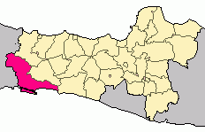
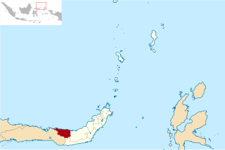
Sampang Regency is a regency of East Java province, Indonesia. It is situated on Madura Island, bordering on Pamekasan Regency to the east, the Java Sea to the north, Bangkalan Regency to the west, and Madura Strait to the south. It covers an area of 1,228.25 km2, and had a population of at the 2010 census 877,772 and at the 2020 census 969,694; the official estimate as of mid-2023 was 988,360 - comprising 488,900 males and 499,460 females. The administrative centre is the port of Sampang, on the south coast of Madura.

<span class="mw-page-title-main">Labuhanbatu Regency</span> Regency in North Sumatra, Indonesia

Labuhanbatu Regency, alternatively written in space as Labuhan Batu Regency, is a regency of North Sumatra Province in Indonesia. Its administrative seat is Rantau Prapat. An original regency of the province, it had an area of 9,703 km2 as at early 2008, prior to the separation out of its southern and its north-western districts respectively to create the new South Labuhanbatu and North Labuhanbatu Regencies on 21 July 2008.

<span class="mw-page-title-main">Mamuju Regency</span> Regency in West Sulawesi, Indonesia

Mamuju Regency is a regency of West Sulawesi province, Indonesia. The regency capital is at Karema, while Mamuju town is the capital of West Sulawesi. The population of the regency was 336,879 at the 2010 Census, but it was substantially reduced by the creation of the new Central Mamuju Regency which was cut out of it on 14 December 2012. The reduced Mamuju Regency covers an area of 4,979.89 km2 and had a population of 278,764 at the 2020 Census; the official estimate as at mid 2023 was 292,395.

<span class="mw-page-title-main">Pinrang Regency</span> Regency in South Sulawesi, Indonesia

Pinrang Regency is one of the twenty-one regencies in South Sulawesi Province of Indonesia. Pinrang town is the administrative capital of Pinrang Regency. The regency covers 1,961.77 km2 and had a population of 351,161 at the 2010 Census and 403,994 at the 2020 Census; the official estimate as at mid 2022 was 411,795.

<span class="mw-page-title-main">East Luwu Regency</span> Regency in South Sulawesi, Indonesia

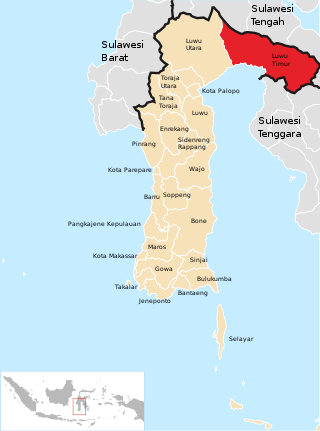
East Luwu Regency is the most easterly of the twenty-one regencies in South Sulawesi Province of Indonesia. The regency was created on 25 February 2003 by separation of the eastern districts from North Luwu Regency. It covers a land area of 6,747.93 km2. The administrative capital of the regency is the coastal town of Malili on the Bay of Usu, itself an inlet in the northeast corner of the Gulf of Bone; the town, with its port of Balantang, is the shipping port for one of the world's major nickel-producing plants. The population of the Regency was 243,069 at the 2010 Census and 296,741 at the 2020 Census; the official estimate as at mid 2023 was 313,404.

<span class="mw-page-title-main">Siau Tagulandang Biaro Islands Regency</span> Regency in North Sulawesi, Indonesia

Sitaro Islands Regency is a regency located off the northern extremity of Sulawesi Island in the southern Sangihe Islands, North Sulawesi Province, Indonesia. The regency was formed under Law Number 15 Year 2007 from 2 January 2007, by separation from the Sangihe Islands Regency of which it had previously formed the southern part. The short form of the name is formed from those of the three principal islands — Siau, Tagulandang and Biaro.

<span class="mw-page-title-main">Sinjai Regency</span> Regency in South Sulawesi, Indonesia

Sinjai Regency is a regency of the South Sulawesi province of Indonesia. The regency, which is separated from the Bone Regency to its north by the River Tangka, covers an area of 819.96 km2. It had a population of 228,936 at the 2010 census and 259,478 at the 2020 census. The official estimate of population as of mid-2022 was 263,827. It includes the Nine Islands in the Gulf of Bone off the east coast of the southern peninsula of Sulawesi; this archipelago forms a district within the regency. The regency's principal town lies at Sinjai, a port situated on the east coast of that peninsula.

<span class="mw-page-title-main">Takalar Regency</span> Regency in South Sulawesi, Indonesia

Takalar Regency is a regency of South Sulawesi Province, Indonesia. It covers an area of 566.51 km2 and had a population of 269,603 at the 2010 census and 300,853 at the 2020 census; the official estimate for mid 2023 was 326,044. The entire regency lies within the official metropolitan area of the city of Makassar. The principal towns are at Galesong and Takalar, but the administrative centre is at Pattallassang.

<span class="mw-page-title-main">Tolitoli Regency</span> Regency in Central Sulawesi, Indonesia

Tolitoli Regency is a regency of Central Sulawesi Province of Indonesia. It was previously part of a larger Buol Tolitoli Regency, but this was split into two on 4 October 1999 after rapid decentralization of the Indonesian government. The present Tolitoli Regency covers an area of 3,701.54 km2 and had a population of 211,296 at the 2010 Census and 225,154 at the 2020 Census; the official estimate as at mid 2023 was 231,711, comprising 118,180 male and 113,530 female inhabitants. Its regency seat is located at the town of Tolitoli, which is a port town and where the regency's population is concentrated.

<span class="mw-page-title-main">North Bolaang Mongondow Regency</span> Regency in North Sulawesi, Indonesia

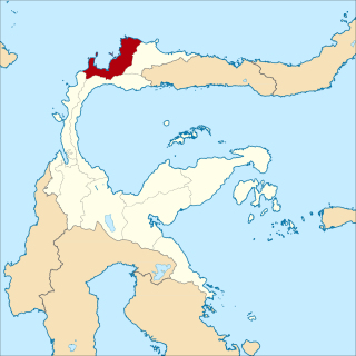
North Bolaang Mongondow Regency is a regency of North Sulawesi Province of Indonesia. It was created on 2 January 2007 by splitting off districts which were previously part of Bolaang Mongondow Regency. The regency covers an area of 1,672.61 km2 and had a population of 70,693 at the 2010 Census and 83,112 at the 2020 Census; the official estimate as at mid 2022 was 84,543. Bitauna is the only official town (kelurahan) in the regency, but the administrative centre is at Boroko.

<span class="mw-page-title-main">North Minahasa Regency</span> Regency in North Sulawesi, Indonesia

North Minahasa Regency is a regency in North Sulawesi, Indonesia. Its capital is Airmadidi. It was originally part of the Minahasa Regency until it was split off and established as a separate regency on 20 November 2003. It covers an area of 1,059.24 km2, and had a population of 188,904 at the 2010 Census; this had risen to 224,993 at the 2020 Census, and the official estimate as at mid 2022 was 229,368. The Regency includes the offshore islands of Bangka and Talisei to the north of Sulawesi, and Mantenang and Naeng Besar to the northwest.

<span class="mw-page-title-main">South Minahasa Regency</span> Regency in North Sulawesi, Indonesia

South Minahasa Regency is a regency in North Sulawesi, Indonesia. Its capital is the town of Amurang. It was originally part of the Minahasa Regency until it was established as a separate regency on 25 February 2003. In turn, a Southeast Minahasa Regency was established as a separate regency from part of the South Minahasa Regency on 2 January 2007. The residual Regency now covers an area of 1,456.46 km2, and had a population of 195,553 at the 2010 Census; this had risen to 236,463 at the 2020 Census; the official estimate as at mid 2022 was 241,680.

<span class="mw-page-title-main">Southeast Minahasa Regency</span> Regency in North Sulawesi, Indonesia

Southeast Minahasa Regency is a regency in North Sulawesi, Indonesia. It covers an area of 710.83 km2, and had a population of 100,443 at the 2010 Census; this had risen to 116,323 at the 2020 Census, and the official estimate as at mid 2022 was 118,023. It was established as a separate regency from part of the South Minahasa Regency on 2 January 2007. Its administrative centre is at the town of Ratahan; Ratahan is also a language spoken in the Regency.

<span class="mw-page-title-main">Manokwari Regency</span> Regency in West Papua, Indonesia

Manokwari Regency is a regency in West Papua, Indonesia. Following the splitting away of twenty of its former districts in 2013, it now covers an area of 3,168.28 km2 and had a population of 192,663 at the 2020 Census; the official estimate as at mid 2022 was 200,785. The administrative centre is presently at the town of Manokwari, which is also the capital of the province, but under proposals currently under consideration by the Indonesian Parliament, the town is intended to be split off from the regency to form a separate independent city.

<span class="mw-page-title-main">Benteng, Selayar Islands</span> Town in South Sulawesi, Indonesia

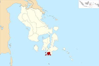
Benteng is a town and an administrative district in the Selayar Islands Regency, South Sulawesi, Indonesia. It is the administrative capital of the Selayar Islands Regency and is located on the seafront where the means of transport from outside the closest is Benteng Pier. The nearest airport and is the only airport H. Aroeppala Airport located in Padang few miles south of Benteng Bontosunggu precisely in the village, Bontoharu District, Selayar Islands Regency. It had a population of 21,344 at the 2010 Census and 24,849 at the 2020 Census; the official estimate as at mid 2022 was 25,397.

<span class="mw-page-title-main">West Muna Regency</span> Regency in Southeast Sulawesi, Indonesia

West Muna Regency is a new regency of Southeast Sulawesi Province of Indonesia,and is situated in the northwest corner of Muna Island and smaller ilsands of its coast. It was established under Act No.14 of 2014, dated 23 July 2014 by separation from the Muna Regency. It covers an area of 906.28 km2, and the districts comprising it had a population of 71,632 at the 2010 Census; the 2020 Census resulted in a population of 84,590, and the official estimate as at mid 2022 was 85,706, comprising 42,242 males and 43,464 females. The administrative centre lies at Laworo in the Tiworo Islands District.

<span class="mw-page-title-main">Central Buton Regency</span> Regency in Southeast Sulawesi, Indonesia

Central Buton Regency is a new regency of Southeast Sulawesi established by separation from Buton Regency under Act No.15 of 2014, dated 23 July 2014. It covers an area of 837.16 km2 comprising the southern parts of Muna Island and Kabaena Island, together with several small offshore islands adjacent to these two main islands, but with no territory located on Buton Island. It had a population of 86,112 at the 2010 Census and 114,773 at the 2020 Census; the official estimate as at mid 2023 was 121,369. The administrative centre lies at Labungkari in Lakudo District.

<span class="mw-page-title-main">South Buton Regency</span> Regency in Southeast Sulawesi, Indonesia

South Buton Regency is a regency located on Buton Island in Southeast Sulawesi Province of Indonesia. This regency was formed from the southern part of Buton Regency, from which it was separated by Act No.16 of 2014, dated 23 July 2014. It covers an area of 546.58 km2, and the population of the districts now comprising the new regency was 74,974 at the 2010 Census and 95,261 at the 2020 Census; the official estimate as at mid 2023 was 101,635. The regency capital is located in Batauga.

References

  1. 1 2 3 Badan Pusat Statistik, Jakarta, 28 February 2024, Kabupaten Kepulauan Selayar Dalam Angka 2024 (Katalog-BPS 1102001.7301)
  2. 1 2 Biro Pusat Statistik, Jakarta, 2011.
  3. 1 2 Badan Pusat Statistik, Jakarta, 2021.
  4. Fadly Syarif. "Kampung Penyu dalam kemeriahan Takabonerate Island Expedition 2013" . Retrieved 7 June 2014.