The Banggai Regency is a regency located at the eastern end of Central Sulawesi Province of Indonesia. It makes up a re-established regency (kabupaten), created on 4 October 1999 by splitting the existing Banggai Regency into this smaller Banggai Regency situated on the mainland of Sulawesi and a new Banggai Islands Regency comprising the offshore islands which are separated from mainland Sulawesi by the Peleng Straits. The residual Banggai Regency covers an area of 9,672.70 km2 and had a population of 323,626 at the 2010 census and 362,275 at the 2020 census; the official estimate as at mid 2022 was 366,224.

Pamekasan Regency is a regency (kabupaten) of the province of East Java, Indonesia. It is located on Madura Island approximately 120 kilometres (75 mi) east of Surabaya, the provincial capital. The regency covers an area of 792.30 square kilometres (305.91 sq mi), and at the 2010 census it had a population of 795,918 ; at the 2020 census the total was 850,057 and the official estimate as at mid 2022 was 857,818 – comprising 420,612 males and 437,206 females. The administrative capital is the town of Pamekasan.

Gorontalo is a regency of Gorontalo Province, Indonesia, on the island of Sulawesi. It was established in 1959 under Law Number 29/1959, but has subsequently been reduced in area as additional regencies have been cut out of it. It now has an area of 2,125.47 km2 and had a population of 355,988 at the 2010 Census and 393,107 at the 2020 Census; the official estimate as at mid 2022 was 398,801. The administrative headquarters of the regency is in the town of Limboto.
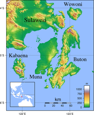
Kabaena or Tokotua is an island in the Flores Sea, Indonesia, off the coast of Sulawesi. Most of it is a part of Bombana Regency within Southeast Sulawesi province, although the southernmost district is administratively part of Central Buton Regency. The island's area is 891.49 km2 and its total population at the 2010 Census was 35,558 and at the 2020 Census was 42,877; the official estimate as at mid 2022 was 44,150.

Soppeng Regency is a landlocked regency in South Sulawesi province of Indonesia. Soppeng Regency has its seat of government (capital) in the town of Watansoppeng, located 180 km from Makassar. The regency covers an area of 1,557 km2, and had a population of 223,826 at the 2010 Census and 235,167 at the 2020 Census; the official estimate as at mid 2022 was 236,049.

Buol Regency is a regency of Central Sulawesi Province of Indonesia. It was created on 4 October 1999, having previously been the eastern half of a larger Buol Tolitoli Regency. It covers an area of 4,043.57 km2, and had a population of 132,330 at the 2010 Census; and 145,254 at the 2020 Census; the official estimate as at mid 2022 was 148,246. The administrative centre is the town of Buol, in Biau District.

Pasangkayu Regency is one of the six regencies which comprise West Sulawesi Province, Indonesia, on the island of Sulawesi. It covers an area of 3,043.75 km2 and had a population of 134,303 at the 2010 Census and 188,861 at the 2020 Census. The official estimate as at mid 2022 was 198,608. The town of Pasangkayu is the capital of the regency, and its only urban community (kelurahan).

Bantaeng Regency is a regency of South Sulawesi Province in Indonesia. It covers an area of 395.83 km2 and had a population of 176,984 at the 2010 Census, rising to 196,716 at the 2020 Census. The official estimate as at mid 2022 was 199,399. The administrative centre is the town of Bantaeng, which lies on the south coast of the southern peninsula of Sulawesi island.

Barru Regency is a regency of South Sulawesi Province of Indonesia. It covers an area of 1,174.72 km2 and had a population of 165,983 at the 2010 Census and 184,452 at the 2020 Census; the official estimate as at mid 2022 was 186,910. The principal town lies at Barru.

Bone Regency is a regency of South Sulawesi, Indonesia. Originally the seat of the Bone state, it joined Indonesia in 1950. The regency covers an area of 4,559.00 km2 and had a population of 717,682 at the 2010 census and 801,775 at the 2020 census the official estimate as at mid 2022 was 813,188. Its main products are seaweed, rice, and fish. The principal town is Watampone, which comprises the three districts of Tanete Riattang Barat, Tanete Riattang and Tanete Riattang Timur within the regency.

Jeneponto Regency is a regency of South Sulawesi Province of Indonesia. It covers most of the south coast of the southern peninsula of Sulawesi, with a total area of 749.79 km2 and a population of 342,222 at the 2010 Census and 401,610 at the 2020 Census. The official estimate for mid 2022 was 410,639. The principal town lies at Bontosunggu. The northern part of the regency consists of a plateau with an altitude of 500 to 1400 metres above sea level, the middle part has an altitude of 100 to 500 metres, while the south includes lowland areas with an altitude of 0 to 150 metres, including a coastline of 114 km on the Flores Sea.

North Luwu Regency is a regency of South Sulawesi Province of Indonesia. It was created on 20 April 1999 by separation of the province's northern districts formerly within the Luwu Regency; however on 25 February 2003 it was reduced when the easternmost of these same districts were split off to create the East Luwu Regency. It now covers 7,502.58 km2 and had a population of 287,606 at the 2010 census and 322,919 at the 2020 census; the official estimate as at mid 2022 was 327,820. The principal town lies at Masamba.

The Pangkajene and Islands Regency, is a regency of South Sulawesi Province of Indonesia. The regency lies primarily on the mainland of Sulawesi's southern peninsula, but also includes the Spermonde Islands off the west coast of that peninsula, as well as other small islands further west and southwest. The principal town lies at Pangkajene on Sulawesi, but there are a series of further small towns like Lejang, Labakkang, Bonto-Bonto and Segeri proceeding northwards from Pangkajene along the Trans-Sulawesi Highway. The total land area is 1,112.29 km2, and the population was 305,737 at the 2010 Census and 345,775 at the 2020 Census; the official estimate as at mid 2022 was 351,426.

Takalar Regency is a regency of South Sulawesi Province, Indonesia. It covers an area of 566.51 km2 and had a population of 269,603 at the 2010 census and 300,853 at the 2020 census; the official estimate for mid 2022 was 305,077. The entire regency lies within the official metropolitan area of the city of Makassar. The principal towns are at Galesong and Takalar, but the administrative centre is at Pattallassang.
Buton Regency is a regency of Indonesia's Southeast Sulawesi Province, lying entirely on Buton Island. Until 2014 it had an area of 2,681.22 km2, and a population estimated at 276,944. However, in 2014 it was divided into three regencies, with two new regencies being cut out of it; the residual area now is 1,648.04 km2, and the districts in that area contained a population of 94,388 at the 2010 Census while the 2020 Census produced a total of 115,207; the official estimate as at mid 2022 was 119,353.

The Banggai Archipelago is a group of islands, which are located at the far eastern end of Central Sulawesi, Indonesia. It makes up a regency (kabupaten) of Central Sulawesi Province of Indonesia, created on 4 October 1999 by splitting the existing Banggai Regency into a new Banggai Regency situated on the mainland of Sulawesi and a Banggai Islands Regency then comprising the entire archipelago. On 14 December 2012 a further splitting of the Regency was the removal of the more southerly seven districts to form a new Banggai Laut Regency.
Tolitoli Regency is a regency of Central Sulawesi Province of Indonesia. It was previously part of a larger Buol Tolitoli Regency, but this was split into two on 4 October 1999 after rapid decentralization of the Indonesian government. The present Tolitoli Regency covers an area of 3,701.54 km2 and had a population of 211,296 at the 2010 Census and 225,154 at the 2020 Census; the official estimate as at mid 2022 was 228,641, comprising 116,514 male and 112,127 female inhabitants. Its regency seat is located at the town of Tolitoli, which is a port town and where its population is concentrated.

North Toraja is a landlocked regency (kabupaten) of South Sulawesi Province of Indonesia, and the home of the Toraja ethnic group. The local government seat is in Rantepao which is also the center of Toraja culture. Formerly this regency was the northern part of Tana Toraja Regency, but on 24 June 2008 the northeastern 36% of the latter's area was split off to form this separate North Toraja Regency. It covers an area of 1,151.47 km2 and had a population of 216,762 at the 2010 census and 261,086 at the 2020 census; the official estimate as at mid 2022 was 268,198, comprising 136,998 males and 131,200 females.

Konawe Islands Regency is a new regency of Southeast Sulawesi, Indonesia, established in 2013 from part of Konawe Regency and consisting of the seven districts comprising Wawonii Island. It covers an area of 705.71 km2, and had a population of 28,944 at the 2010 Census and 37,050 at the 2020 Census; the official estimate as at mid 2022 was 38,383. The administrative centre lies at the town of Langara.
Banggai Sea Regency is a regency in the province of Central Sulawesi, Indonesia. The regency was established on 14 December 2012, partitioned from the Banggai Islands Regency. It comprises southern part of the Banggai Islands archipelago, including the main island of Banggai itself, the islands of Labobo and Bangkurung to the southwest of Banggai Island, and the numerous small Bokan Islands to the southeast. It covers a land area of 725.67 km2, and the districts now comprising the new Regency had a population of 62,183 at the 2010 Census and 70,435 at the 2020 Census; the official estimate as at mid 2022 was 71,350.