Sikka is a regency within East Nusa Tenggara province, Indonesia, on the island of Flores. It is bordered to the west by Ende Regency and to the east by East Flores Regency. It covers an area of 1,731.91 km2 and had a population of 300,301 at the 2010 census and 321,953 at the 2020 Census; the official estimate as at mid 2022 was 326,999. The capital is the town of Maumere, which comprises the districts of Alok Barat, Alok and Alok Timur.
Tanah Laut Regency is one of the regencies in the Indonesian province of South Kalimantan. It encompasses the southernmost part of Kalimantan (Borneo). The area is 3,631.35 km2, and the population was 296,333 at the 2010 Census and 348,966 at the 2020 Census; the official estimate as at mid 2022 was 361,044. The capital is the town of Pelaihari. Motto: "Tuntung Pandang" (Banjarese). Tuntung Pandang have meaning as "nice to see until forever"

West Kutai Regency is a regency (kabupaten) in the Indonesian province of East Kalimantan. It previously covered a much greater area, with a population of 165,091 at the 2010 Census, but in December 2012 the five northernmost districts were split off to form a new Mahakam Ulu Regency; the residual area of 20,384.6 km2 had a population of 140,097 at the 2010 Census, and 165,938 at the 2020 Census; the official estimate as at mid 2022 was 172,288. The town of Sendawar is the administrative capital.
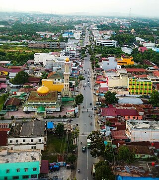
Rantauprapat is a town in North Sumatra province of Indonesia and it is the seat (capital) of Labuhan Batu Regency. Rantauprapat is also a village within the district of Rantau Utara. It consists of 3 main roads. A number of citizens move to larger cities like Medan in search for more job opportunities and/or universities. A large river named the Bilah River runs through the town, which had 140,778 inhabitants at the 2010 Census, 170,462 at the 2020 Census, and 175,960 according to the official estimates as at mid 2022.
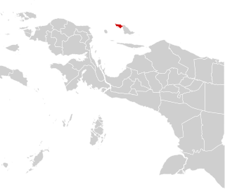
Supiori Regency is a regency in the Indonesian province of Papua. The Regency has an area of 634.24 km2 including the Aruri Islands group to the south, and had a population of 15,874 at the 2010 Census and 22,547 at the 2020 Census; the official estimate as at mid 2022 was 23,247 - comprising 12,056 males and 11,191 females. Until 8 January 2004, this area was part of the Biak Numfor Regency, from which it was split off in accordance with the Law dated 18 December 2003.

Yapen Islands Regency is a regency (kabupaten) in Papua Province of eastern Indonesia. It covers an area of 2,432.49 km2 (939.19 sq mi), and had a population of 82,951 at the 2010 Census and 112,676 at the 2020 Census; the official estimate as at mid 2022 was 116,107. It comprises an archipelago which lies in Cenderawasih Bay off the north coast of Western New Guinea.
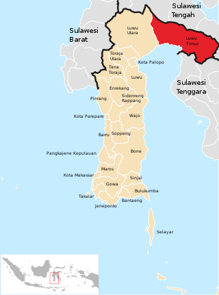
East Luwu Regency is the most easterly of the twenty-one regencies in South Sulawesi Province of Indonesia. The regency was created on 25 February 2003 by separation of the eastern districts from North Luwu Regency. It covers an area of 6,944.88 km2. The administrative capital of the regency is the coastal town of Malili on the Bay of Usu, itself an inlet in the northeast corner of the Gulf of Bone; the town, with its port of Balantang, is the shipping port for one of the world's major nickel-producing plants. The population of the Regency was 243,069 at the 2010 Census and 296,741 at the 2020 Census; the official estimate as at mid 2022 was 305,521.

West Sumbawa Regency is a Regency (Kabupaten) of the Indonesian Province of West Nusa Tenggara. It is located on the island of Sumbawa and has an area of 1,743.58 km2. The regency was created on 18 December 2003 from what were at that time the westernmost five districts (kecamatan) of Sumbawa Regency. The population at the 2010 Census was 114,754, and at the 2020 Census was 145,798; the official estimate as at mid 2022 was 151,775 - comprising 76,959 males and 74,816 females. The capital is the town of Taliwang.

Paser Regency is a regency (kabupaten) within East Kalimantan province in Indonesia, it is the southernmost regency of the East Kalimantan province. Its administrative centre is Tana Paser. It covers an area of 7,730 km2, and it had a population of 230,316 at the 2010 Census and 275,452 at the 2020 Census; the official estimate as at mid 2022 was 280,065 . Before 2007, this regency was formerly named Pasir Regency.

Pasangkayu Regency is one of the six regencies which comprise West Sulawesi Province, Indonesia, on the island of Sulawesi. It covers an area of 3,043.75 km2 and had a population of 134,303 at the 2010 Census and 188,861 at the 2020 Census. The official estimate as at mid 2022 was 198,608. The town of Pasangkayu is the capital of the regency, and its only urban community (kelurahan).
Sukamara Regency is one of the thirteen regencies which comprise the Central Kalimantan Province on the island of Kalimantan (Borneo), Indonesia. It was created on 10 April 2002 from the former southwest part of West Kotawaringin Regency. The town of Sukamara is the capital of Sukamara Regency, which covers an area of 3,827 km2. The population of the Regency was 44,952 at the 2010 Census and 63,464 at the 2020 Census; the official estimate as at mid 2022 was 66,845.
East Lampung Regency is a regency (kabupaten) of Lampung Province, Sumatra, Indonesia. It has an area of 5,325.03 km2 and a population of 951,639 people at the 2010 census and 1,110,340 at the 2020 census. The official estimate as at mid 2022 was 1,127,946. The regency seat is at the town of Sukadana.

Bantaeng Regency is a regency of South Sulawesi Province in Indonesia. It covers an area of 395.83 km2 and had a population of 176,984 at the 2010 Census, rising to 196,716 at the 2020 Census. The official estimate as at mid 2022 was 199,399. The administrative centre is the town of Bantaeng, which lies on the south coast of the southern peninsula of Sulawesi island.
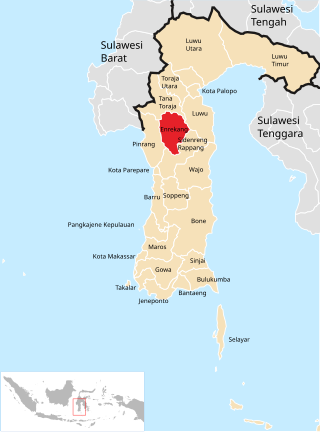
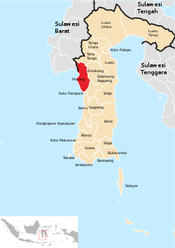
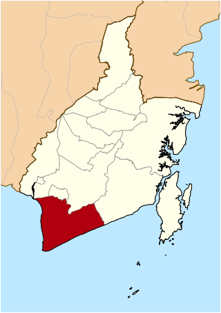
Enrekang Regency is an inland regency of South Sulawesi Province of Indonesia. It covers an area of 1,821.53 km2 and had a population of 190,175 at the 2010 census and 225,172 at the 2020 census; the official estimate as at mid 2022 was 228,554. The principal town lies at Enrekang.

Jeneponto Regency is a regency of South Sulawesi Province of Indonesia. It covers most of the south coast of the southern peninsula of Sulawesi, with a total area of 749.79 km2 and a population of 342,222 at the 2010 Census and 401,610 at the 2020 Census. The official estimate for mid 2022 was 410,639. The principal town lies at Bontosunggu. The northern part of the regency consists of a plateau with an altitude of 500 to 1400 metres above sea level, the middle part has an altitude of 100 to 500 metres, while the south includes lowland areas with an altitude of 0 to 150 metres, including a coastline of 114 km on the Flores Sea.

Takalar Regency is a regency of South Sulawesi Province, Indonesia. It covers an area of 566.51 km2 and had a population of 269,603 at the 2010 census and 300,853 at the 2020 census; the official estimate for mid 2022 was 305,077. The entire regency lies within the official metropolitan area of the city of Makassar. The principal towns are at Galesong and Takalar, but the administrative centre is at Pattallassang.

Kolaka Regency is a regency of Southeast Sulawesi Province, Indonesia. It covers an area of 2,958.69 km2 (1,142.36 sq mi) and had a population of 208,817 at the 2010 Census, rising to 237,587 at the 2020 Census; the official estimate as at mid 2022 was 246,137. The principal town lies at Kolaka.

South Konawe Regency is a regency of Southeast Sulawesi Province, Indonesia. It covers an area of 4,237.74 km2 and had a population of 264,587 at the 2010 Census and of 308,524 at the 2020 Census; the official estimate as at mid 2022 was 317,826 - comprising 162,949 males and 154,877 females. The administrative centre is in the town of Andoolo.
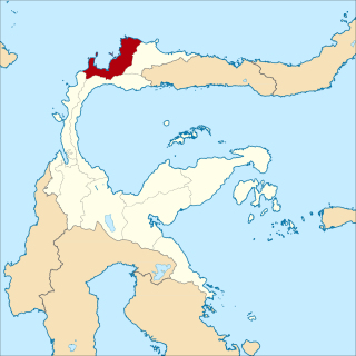
Tolitoli Regency is a regency of Central Sulawesi Province of Indonesia. It was previously part of a larger Buol Tolitoli Regency, but this was split into two on 4 October 1999 after rapid decentralization of the Indonesian government. The present Tolitoli Regency covers an area of 3,701.54 km2 and had a population of 211,296 at the 2010 Census and 225,154 at the 2020 Census; the official estimate as at mid 2022 was 228,641, comprising 116,514 male and 112,127 female inhabitants. Its regency seat is located at the town of Tolitoli, which is a port town and where its population is concentrated.

Bolaang Mongondow Regency is a regency of North Sulawesi Province, Indonesia, situated on the island of Sulawesi. The principal town lies at Kotamobagu, which since 2007 has been administratively separated from the regency, the administrative centre of which is now at the town of Lolak. The Regency covers an area of 2,871.65 km2, and had a population of 213,484 at the 2010 Census and 248,751 at the 2020 Census; the official estimate as at mid 2022 was 252,648.