San Antonio de los Cobres

Last updated
San Antonio de los Cobres
San antonio de los cobres view.jpg
A panoramic view of the town, as seen from
the Tren de las Nubes train station
Departamento Los Andes (Salta - Argentina).png
San Antonio (yellow dot) within Los Andes Department (red) and Salta Province
Argentina location map.svg
Red pog.svg
San Antonio de los Cobres
Coordinates: 24°13′04″S66°19′12″W / 24.21778°S 66.32000°W / -24.21778; -66.32000
CountryFlag of Argentina.svg  Argentina
Province Bandera de la Provincia de Salta.svg  Salta
Department Flag of None.svg Los Andes
Established?
Government
  MayorGuzmán Viveros
Elevation
3,775 m (12,385 ft)
Population
 (2001)
  Total5,482
Time zone UTC−3 (ART)
Postal code
A4411
Climate BWk
Website Official website

San Antonio de los Cobres is a small town of population 5,482 (per the 2001 INDEC census) [1] in northwestern Argentina. It is the capital of the Los Andes Department of the Salta Province. [2]

Contents

Geography

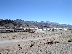
The town is known for its high elevation of approximately 3,775 meters (12,385 feet) above sea level, being one of the highest elevations of any city or town in Argentina. [2] It is located approximately 160 kilometers (99 mi) from the city of Salta and 2,000 kilometers (1,200 mi) from the capital, Buenos Aires. [2] It is part of the Andes desert and described to be an arid region with few trees and scarce drinking water.

History

San Antonio de los Cobres was established in the early 17th century, specifically in 1641. It was founded as a small settlement to support the mining activities in the region and has since developed into a key town in the high Andes of Argentina. The town's history is closely tied to its mining heritage and the Indigenous cultures of the area. In a 2015 podcast from The Naked Scientists , research has shown that people in the San Antonio de los Cobres area have remarkably developed a mutation in their genes to cope with the high levels of arsenic in the area. Having concentrations about ten times higher that those deemed safe by the World Health Organization (WHO), naturally occurring arsenic has created a very toxic environment in this region contaminating the water supplies. Evolutionary processes resulting from long term exposure have caused a specific mutation within the DNA of this population allowing them to process arsenic more quickly throughout their systems and preventing the formation of poisonous byproducts that would normally form within the body with exposure to the element. This is the first adaptation in humans regarding a toxic chemical to ever be documented. [3]

Economy

San Antonio de las Cobres takes its name from the nearby Sierra de Cobre , or Copper Mountain, which is rich in that mineral. Economic activity in the town is based on mining of the mineral-rich surrounding mountains, and weaving using local llama wool. [4] The town is also a stop along the Tren a las Nubes (Train of the Clouds), [4] on the Salta-Antofagasta rail line.

Climate

San Antonio de los Cobres has a cool arid climate (Köppen BWk) characterised by mild summers, cold, bone-dry winters, and very large diurnal temperature variation due to the extreme altitude. Rainfall is essentially nil except from January to March, when 96 millimetres (3.78 in) of an annual total of 104 millimetres (4.09 in) falls from thunderstorms.

Climate data for San Antonio de los Cobres
MonthJanFebMarAprMayJunJulAugSepOctNovDecYear
Record high °C (°F)25.4
(77.7)
25.0
(77.0)
25.0
(77.0)
21.2
(70.2)
24.5
(76.1)
18.0
(64.4)
17.3
(63.1)
18.3
(64.9)
20.0
(68.0)
23.5
(74.3)
23.2
(73.8)
27.0
(80.6)
27.0
(80.6)
Mean daily maximum °C (°F)20.4
(68.7)
20.4
(68.7)
18.8
(65.8)
17.9
(64.2)
13.8
(56.8)
11.6
(52.9)
11.9
(53.4)
12.1
(53.8)
13.6
(56.5)
17.3
(63.1)
18.4
(65.1)
21.0
(69.8)
16.4
(61.5)
Daily mean °C (°F)12.7
(54.9)
12.5
(54.5)
11.2
(52.2)
9.6
(49.3)
5.9
(42.6)
3.5
(38.3)
2.2
(36.0)
3.2
(37.8)
7.0
(44.6)
10.6
(51.1)
12.3
(54.1)
12.4
(54.3)
8.6
(47.5)
Mean daily minimum °C (°F)4.2
(39.6)
2.9
(37.2)
1.4
(34.5)
−2.9
(26.8)
−5.7
(21.7)
−7.0
(19.4)
−7.7
(18.1)
−6.7
(19.9)
−4.6
(23.7)
−1.0
(30.2)
0.5
(32.9)
1.8
(35.2)
−2.1
(28.2)
Record low °C (°F)−0.3
(31.5)
−2.0
(28.4)
−4.8
(23.4)
−8.5
(16.7)
−13.2
(8.2)
−14.5
(5.9)
−16.0
(3.2)
−13.0
(8.6)
−13.8
(7.2)
−9.2
(15.4)
−7.5
(18.5)
−3.5
(25.7)
−16.0
(3.2)
Average precipitation mm (inches)44.0
(1.73)
32.7
(1.29)
19.4
(0.76)
0.4
(0.02)
0.2
(0.01)
0.0
(0.0)
0.0
(0.0)
1.5
(0.06)
0.6
(0.02)
0.0
(0.0)
1.1
(0.04)
4.0
(0.16)
103.9
(4.09)
Average relative humidity (%)54494436424458443634374743.8
Source: Secretaria de Mineria [5]

Related Research Articles

<span class="mw-page-title-main">Geography of Argentina</span>

The geography of Argentina is heavily diverse, consisting of the Andes Mountains, pampas, and various rivers and lakes. Bordered by the Andes in the west and the South Atlantic Ocean to the east, its neighbouring countries are Chile to the west, Bolivia and Paraguay to the north, and Brazil and Uruguay to the northeast.

<span class="mw-page-title-main">Río Negro Province</span> Province of Argentina

Río Negro is a province of Argentina, located in northern Patagonia. Neighboring provinces are from the south clockwise Chubut, Neuquén, Mendoza, La Pampa and Buenos Aires. To the east lies the Atlantic Ocean.

<span class="mw-page-title-main">Salta Province</span> Province of Argentina

Salta is a province of Argentina, located in the northwest of the country. Neighboring provinces are from the east clockwise Formosa, Chaco, Santiago del Estero, Tucumán and Catamarca. It also surrounds Jujuy. To the north it borders Bolivia and Paraguay and to the west lies Chile.

<span class="mw-page-title-main">Trevelin</span> Town in Chubut, Argentina

Trevelin is a town in the western part of the Patagonian Argentine province of Chubut. The town lies on the eastern banks of the Percy River. It is located in the department of Futaleufú, 22 kilometres (14 mi) south of Esquel, and had 6,395 inhabitants at the time of the 2001 census [INDEC] and 7,908 inhabitants in the 2010 census [INDEC].

<span class="mw-page-title-main">Argentine Northwest</span>

The Argentine Northwest is a geographic and historical region of Argentina composed of the provinces of Catamarca, Jujuy, La Rioja, Salta, Santiago del Estero and Tucumán.

<span class="mw-page-title-main">National Route 40 (Argentina)</span> Highway in Argentina

National Route 40, also known as RN40 or "Ruta 40", is a route in western Argentina, stretching from Cabo Vírgenes near Río Gallegos in Santa Cruz Province in the south to La Quiaca in Jujuy Province in the north with approximately 5194 km length. The route parallels the Andes mountains. The southern part of the route, by now largely paved, has become a well-known adventure tourism journey, and there are plans to pave the whole road.

<span class="mw-page-title-main">Andalgalá</span> City in Catamarca, Argentina

Andalgalá is a city in the west-center of the province of Catamarca, Argentina, located in a valley near the Sierra de Aconquija, 260 km from the provincial capital San Fernando del Valle de Catamarca. It has about 14,000 inhabitants as per the 2001 census [INDEC]. It is the head town of the department of the same name. The Andalgalá River, which flows nearby, supports a hydroelectric power plant.

<span class="mw-page-title-main">Tilcara</span> City in Jujuy, Argentina

San Francisco de Tilcara is a city in the province of Jujuy, Argentina, and the head town of the Tilcara Department. It had 6,249 inhabitants at the 2010 census [INDEC]. Traces of human habitation in the area date back more than 10,000 years, making it one of the oldest continuously inhabited settlements of Argentina.

El Cobre or Cobre is a Spanish word meaning "Copper". It may also refer to:

<span class="mw-page-title-main">Nevado Queva</span> Mountain in Argentina

Nevado Queva or Quewar is a volcano in the Andes mountain range of South America, located in the Salta Province of Argentina. Queva has a summit elevation of 6,140 metres (20,144 ft) above sea level. Its name is alternately spelled Quehuar. There are extensive pre-Columbian ruins on the summit of the mountain, which is a broad crater.

<span class="mw-page-title-main">Rosario de Lerma Department</span> Department in Salta, Argentina

Rosario de Lerma is a department located in Salta Province, Argentina. Its main settlements are Rosario de Lerma and Campo Quijano.

<span class="mw-page-title-main">Los Andes Department</span> Department in Salta, Argentina

Los Andes is a department located in Salta Province, Argentina. It is the second largest by area in the province, after Rivadavia Department, and its capital is the town of San Antonio de los Cobres.

<span class="mw-page-title-main">La Poma Department</span> Department in Salta, Argentina

La Poma is a department located in Salta Province, Argentina. It is the least populated department of the province and its capital is the town of La Poma.

<span class="mw-page-title-main">Salta–Antofagasta railway</span> Railway line in Argentina and Chile

The Salta–Antofagasta railway, also named Huaytiquina, is a non-electrified single track railway line that links Argentina and Chile passing through the Andes. It is a 1,000 mmmetre gauge railway with a total length of 941 km, connecting the city of Salta (Argentina) to the one of Antofagasta (Chile), on the Pacific Ocean, passing through the Puna de Atacama and Atacama Desert.

<span class="mw-page-title-main">Sico Pass</span>

Sico Pass is a mountain pass on the border between Argentina and Chile. The pass is located on the main divide of the Andes. Administratively, it separates the province of Salta in Argentina and the region of Antofagasta in Chile.

Nevados de Pastos Grandes is a Miocene volcanic centre in the Puna, Salta province, Argentina. It is a volcanic complex with several centres named El Queva, Gordo and Azufre. Some minor Pleistocene glaciation has affected the volcanic complex.

<span class="mw-page-title-main">Nevado de Acay</span>

Nevado de Acay is a 5,950-metre-high (19,520 ft) mountain in Argentina. It is a volcanic intrusion that formed during the Miocene and was later exposed. The intrusion is formed by monzonite and is associated with a fault system that also connects to neighbouring volcanoes.

<span class="mw-page-title-main">Molinos Department</span> Department in Salta, Argentina

Molinos is a department located in Salta Province, Argentina.

<span class="mw-page-title-main">Chalcostibite</span>

Chalcostibite is a copper antimony sulfide mineral.

Cerro Tuzgle is a dormant stratovolcano in the Susques Department of Jujuy Province in northwestern Argentina. Tuzgle is a prominent volcano of the back arc of the Andes and lies about 280 kilometres (170 mi) east of the main volcanic arc. Part of the Central Volcanic Zone of the Andes, its summit is 5,486 metres (17,999 ft) above sea level and it grew during different stages over a caldera and lava domes. Some major lava flows emanate from the summit crater, and one confirmed and one possible flank collapse unit as well as an ignimbrite sheet are associated with Tuzgle.

References

  1. "Cuadro 12.4 Provincia de Salta según localidad. Población por grupos de edad. Año 2001" [Table 12.4 Province of Salta according to locality. Population by age groups. Year 2001]. Censo 2001 (in Spanish). INDEC . Retrieved February 10, 2009.
  2. 1 2 3 "San Antonio de los Cobres". Vivir en Los Cobres (in Spanish). Archived from the original on February 21, 2009. Retrieved February 10, 2009.
  3. Mills, Georgia (9 March 2015). "Adapting to Arsenic". The Naked Scientists .
  4. 1 2 "Salta: San Antonio de los Cobres". Enjoy Travel Argentina. Enjoy Corporation SA. 2009. Archived from the original on March 6, 2016. Retrieved February 10, 2009.
  5. "Provincia de Salta - Clima Y Meteorologia: Datos Meteorologicos Y Pluviometicos". Secretaria de Mineria de la Nacion (Argentina) (in Spanish). Archived from the original on December 8, 2015. Retrieved November 29, 2015.

Commons-logo.svg Media related to San Antonio de los Cobres at Wikimedia Commons