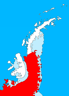
Palmer Land is the portion of the Antarctic Peninsula, Antarctica that lies south of a line joining Cape Jeremy and Cape Agassiz. This application of Palmer Land is consistent with the 1964 agreement between the Advisory Committee on Antarctic Names and the UK Antarctic Place-Names Committee, in which the name Antarctic Peninsula was approved for the major peninsula of Antarctica, and the names Graham Land and Palmer Land for the northern and southern portions, respectively. The line dividing them is roughly 69° S.
Northeast Glacier is a steep, heavily crevassed glacier, 13 nautical miles long and 5 nautical miles wide at its mouth, which flows from McLeod Hill westward and then south-westwards into Marguerite Bay between the Debenham Islands and Roman Four Promontory, on the west coast of Graham Land, Antarctica.
Neny Fjord is a bay, 10 nautical miles long in an east–west direction and 5 nautical miles wide, between Red Rock Ridge and Roman Four Promontory on the west coast of Graham Land, Antarctica.

Cascajares de Bureba is a municipality located in the province of Burgos, Castile and León, Spain. According to the 2004 census (INE), the municipality had a population of 54 inhabitants.

Plasencia de Jalón is a municipality located in the province of Zaragoza, Aragon, Spain. According to the 2004 census (INE), the municipality has a population of 368 inhabitants.
Bocigas is a municipality located in the province of Valladolid, Castile and León, Spain. According to the 2004 census (INE), the municipality has a population of 129 inhabitants.
Simpson Glacier is a glacier, 6 nautical miles, in the Admiralty Mountains, Antarctica. It flows northward to the coast between Nelson Cliff and Mount Cherry-Garrard where it forms the Simpson Glacier Tongue.

The River Sid, situated in East Devon, is often claimed to be the shortest complete river in England. It flows for 6.5 miles (10.5 km) southwards from a source in Crowpits Covert at a height of 206 metres above sea level. The source is at the head of a goyle or small ravine.
Norassoba is a town and sub-prefecture in the Siguiri Prefecture in the Kankan Region of northern Guinea.
Wangat River, a perennial river of the Hunter River catchment, is located in the Hunter region of New South Wales, Australia.

San Pablo de Lípez is a small town in the Potosí Department of Bolivia. It is the seat of the Sur Lípez Province and of the San Pablo de Lípez Municipality.
Las Mojarras is a village and municipality in Catamarca Province in northwestern Argentina.
Puerta de Corral Quemado is a village and municipality in Catamarca Province in northwestern Argentina.
Siján is a village and municipality in Catamarca Province in northwestern Argentina.
The Pecora Escarpment is an irregular escarpment, 7 nautical miles long, standing 35 nautical miles southwest of Patuxent Range and marking the southernmost exposed rocks of the Pensacola Mountains.
The FitzGerald Bluffs are prominent north-facing bluffs, 9 nautical miles long, located 30 nautical miles south of the Snow Nunataks in Ellsworth Land, Antarctica.

National Cycle Network (NCN) Route 647 is a Sustrans National Route that runs from Clumber Park to Harby 53.233°N 0.683°W. The route is 19.6 miles (31.5 km) in length and is fully open and signed in both directions.
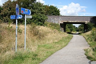
National Cycle Network (NCN) Route 64 is a Sustrans National Route that runs from Market Harborough to Lincoln. The route is 68 miles (109 km) in length and is fully open and signed in both directions. There are three sections to the route, NCN 63 and NCN 15 form the links between these sections.
