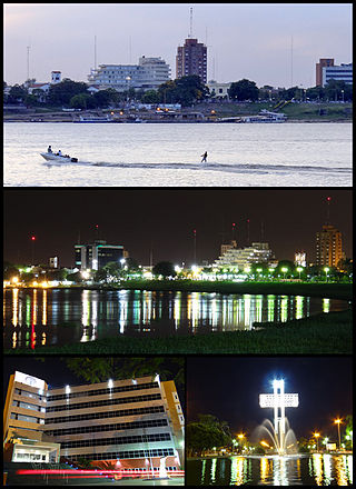
Formosa is the capital city of the Argentine province of Formosa, on the banks of the Paraguay River, opposite the Paraguayan town of Alberdi, about 1,200 km (746 mi) north from Buenos Aires, on National Route 11. The city has a population of about 234,000 per the 2010 census [INDEC].

Salta is a province of Argentina, located in the northwest of the country. Neighboring provinces are from the east clockwise Formosa, Chaco, Santiago del Estero, Tucumán and Catamarca. It also surrounds Jujuy. To the north it borders Bolivia and Paraguay and to the west lies Chile.

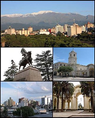
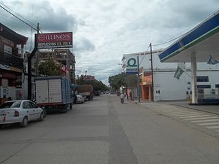
Salta is the capital and largest city in the Argentine province of the same name. With a population of 618,375 according to the 2010 census, it is also the 7th most-populous city in Argentina. The city serves as the cultural and economic center of the Valle de Lerma Metropolitan Area, which is home to over 50.9% of the population of Salta Province and also includes the municipalities of La Caldera, Vaqueros, Campo Quijano, Rosario de Lerma, Cerrillos, La Merced and San Lorenzo. Salta is the seat of the Capital Department, the most populous department in the province.

Resistencia is the capital and largest city of the province of Chaco in north-eastern Argentina. According to the 2010 census, the population of the city proper was 291,720 inhabitants. It is the anchor of a larger metropolitan area, Greater Resistencia, which comprises at least three more municipalities for a total population of 387,340 as of 2010. This conurbation is the largest in the province, and the eleventh most populous in the country. It is located along the Negro River, a tributary of the much larger Paraná River, opposite the city of Corrientes, Corrientes Province.

Santiago del Estero is the capital of Santiago del Estero Province in northern Argentina. It has a population of 252,192 inhabitants, making it the twelfth largest city in the country, with a surface area of 2,116 km2. It lies on the Dulce River and on National Route 9, at a distance of 1,042 km north-northwest from Buenos Aires. Estimated to be 455 years old, Santiago del Estero was the first city founded by Spanish settlers in the territory that is now Argentina. As such, it is nicknamed "Madre de Ciudades". Similarly, it has been officially declared the "mother of cities and cradle of folklore."

Santa Rosa is a city in the Argentine Pampas (lowlands), and the capital of La Pampa Province, Argentina. It lies on the east of the province, on the shore of the Don Tomás Lagoon, at the intersection of National Routes National Route 5 and National Route 35. The city (94,340) and its surroundings hold 102,610 inhabitants ,Census-ar 2.010 hold 124.101 inhabitants the capital y Toay around a third of the population of the province. Its current mayor is Luciano di Nápoli. Founded in 1892 by Tomás Mason, Santa Rosa did not develop into a relatively important agricultural centre until the second half of the 20th century. It is still one of the smallest provincial capitals of the country after Patagonian Rawson, Ushuaia and Viedma.
San Salvador de Jujuy, commonly known as Jujuy and locally often referred to as San Salvador, is the capital and largest city of Jujuy Province in northwest Argentina. Also, it is the seat of the Doctor Manuel Belgrano Department. It lies near the southern end of the Humahuaca Canyon where wooded hills meet the lowlands.
Tarija or San Bernardo de la Frontera de Tarixa is a city in southern Bolivia. Founded in 1574, Tarija is the largest city and capital and municipality within the Tarija Department, with an airport offering regular service to primary Bolivian cities, as well as a regional bus terminal with domestic and international connections. Its climate is semi-arid (BSh) with generally mild temperatures in contrast to the harsh cold of the Altiplano and the year-round humid heat of the Amazon Basin. Tarija has a population of 234,442.

Río Cuarto is a city in the province of Córdoba, Argentina. Located in the south of the province, it has about 157,000 inhabitants and is an important commercial and agricultural hub.
General Pico is a city located in the northeast of La Pampa Province, Argentina. It is located at 143 m (469 ft) above sea level and inside the region of the Pampa Húmeda Llana. It has a surface area of 2,555 km2 (986 sq mi).

Tres Arroyos is a city in Buenos Aires Province, Argentina. It is the administrative seat of Tres Arroyos Partido.
San Ramón de la Nueva Orán is a city in northwest province of Salta, Argentina, about 270 km (170 mi) from the provincial capital, Salta. It is the head town of the Orán Department, and it has about 73,000 inhabitants as per the 2001 census [INDEC], which makes it the second-most populated in the province.

Villa Mercedes is a city in the province of San Luis, Argentina. It lies on the center-east of the province, on the left-hand banks of the Quinto River, 32 km from the border with Córdoba, on National Route 148, and near the intersection of National Routes 8 and 7. National Route 7 links the city to the provincial capital San Luis, 90 km to the north-west. It had 96,781 inhabitants during the 2001 census [INDEC].

Rosario de Lerma is a town in the center of the province of Salta, Argentina.

The climate of Argentina varies from region to region, as the vast size of the country and wide variation in altitude make for a wide range of climate types. Summers are the warmest and wettest season in most of Argentina, except for most of Patagonia, where it is the driest season. The climate is warm in the north, cool in the center, and cold in the southern parts, that experience frequent frost and snow. Because the southern parts of the country are moderated by the surrounding oceans, the cold is less intense and prolonged than areas at similar latitudes in the northern hemisphere. Spring and autumn are transition seasons that generally feature mild weather.

Indian Argentines, also known as Indo-Argentines, are Argentines who have predominantly or total Indian ancestry. There is a small community of Indians in Argentina who are mainly immigrants from India and the neighboring countries in South America and the Caribbean with Indo-Caribbean influence and some of whom were born in Argentina and are of Indian heritage, related to the Indo-Aryan and Dravidian peoples, so the term can also include descendants of Pakistanis, Nepalis, Bengalis and Sinhalese.

Metán is a department located in Salta Province, in Argentina.

Guachipas is a department located in Salta Province, Argentina.

Due to its vast size and range of altitudes, Argentina possesses a wide variety of climatic regions, ranging from the hot subtropical region in the north to the cold subantarctic in the far south. The Pampas region lies between those and featured a mild and humid climate. Many regions have different, often contrasting, microclimates. In general, Argentina has four main climate types: warm, moderate, arid, and cold in which the relief features, and the latitudinal extent of the country, determine the different varieties within the main climate types.

La Candelaria is a department located in Salta Province, Argentina.

