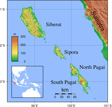
The Mentawai Islands Regency is a regency of West Sumatra Province which consists of a chain of about a hundred islands and islets approximately 150 kilometres (93 miles) off the western coast of Sumatra in Indonesia. They cover a land area of 5,980.76 km2 and had a population of 76,173 at the 2010 Census[3] and 87,623 at the 2020 Census;[4] the official estimate as of mid-2023 was 91,427 - comprising 47,321 males and 44,106 females.[1]Siberut at 3,877.9 square kilometres (1,497 square miles) is the largest of the islands, occupying 64.64% of the land area of the regency. The other major islands are Sipura (or Sipora), North Pagai (Pagai Utara), and South Pagai (Pagai Selatan). The islands lie off the Sumatran coast, across the Mentawai Strait. The indigenous inhabitants of the islands are known as the Mentawai people. The Mentawai Islands have become a noted destination for surfing,[5] with over 40 boats offering surf charters to international guests.[6]
The Mentawai Islands have been administered as a regency within the West Sumatra (Sumatera Barat) province since 1999. The regency seat is Tua Pejat, on the island of Sipora. Padang, the capital of the province, lies on the Sumatran mainland opposite Siberut. The regency is divided into ten districts (kecamatan), tabulated below from south to north with their areas and their populations at the 2010 Census[3] and the 2020 Census,[4] together with the official estimates as at mid-2023.[1] The table also includes the locations of the district administrative centres, the number of villages (all classed as rural desa) and the number of named offshore islands in each district, and its postcode.
Name of District (kecamatan)
English Name
Area in km2
Pop'n 2010 Census
Pop'n 2020 Census
Pop'n mid 2023 Estimate
Admin centre
No. of villages
No. of islands
Post code
Pagai Selatan
South Pagai
852.28
8,782
9,373
9,562
Bulasat
4
31
25391
Sikakap (a)
Central Pagai
312.60
9,531
10,219
10,439
Taikako
3
8
25399
Pagai Utara
North Pagai
317.25
5,212
6,031
6,299
Saumanganya
3
9
25390
Sipora Selatan
South Sipora
348.33
8,460
9,812
10,254
Sioban
7
3
25392
Sipora Utara
North Sipora
272.40
9,097
11,968
12,974
Sido Makmur
6
12
25398
Siberut Selatan
South Siberut
328.00
8,446
9,933
10,423
Muara Siberut
5
1
25397
Siberut Barat Daya
Southwest Siberut
1,013.83
6,069
7,058
7,382
Pasakiat Taileleu
3
17
25393
Siberut Tengah
Central Siberut
589.75
6,069
7,089
7,474
Saibi Samukop
3
5
25396
Siberut Utara
North Siberut
782.68
7,774
8,337
8,512
Muara Sikabaluan
6
4
25395
Siberut Barat
West Siberut
1,163.64
6,733
7,803
8,153
Simalegi
3
1
25394
Totals
5,980.76
76,173
87,623
91,427
Tuapejat
43
111
Note: (a) Sikakap District covers the northern part of South Pagai Island and the southern part of North Pagai Island, plus some intervening small islands. Of the three desa, Matobek is entirely on North Pagai Island, while Sikakap and Taikato are mainly on North Pagai Island but each includes areas on South Pagai as well as the intervening small islands.
Macaronis was first discovered in 1980 by pioneer surf discoverers Chris Goodnow, Scott Wakefield, and Tony Fitzpatrick, who originally named the break ‘P-Land’ on their first visit (after Pasangan Bay / Pagai Islands). Amazingly, and considering the remote location, P-Land may have been the first wave surfed in the Mentawai Islands. Lances Right was discovered a full 10 years later, while Chris, Scott, and Tony continued to keep their discovery a secret. They returned in 1981 with friend Tim Annand, and again on a boat trip in the 90’s.[8][9][10][11]
The first photos of the surf breaks in the Mentawais area were leaked after a surf trip in 1992 aboard the MV Indies Trader, with professional surfers Ross Clarke-Jones, Tom Carroll, and Martin Potter.[12] Ever since then, the Mentawai Islands have been well on the radar of surf travellers around the world. At the West of Sumatra, the Mentawai Islands have the most consistent surf breaks in Indonesia making it one of the preferred choices for serious surfers. The tropical waters surrounding the islands offer year-round waves up to 15 ft (4.5 m).[13][14]
Earthquake and tsunami activity has been high since the 2004 Indian Ocean earthquake. In 1833, the region was hit with an earthquake, possibly similar in size to the 2004 Indian Ocean earthquake;[17] another large earthquake struck in 1797. On October 25, 2010, an earthquake in southern Sumatra led to a deadly tsunami that devastated villages in South and North Pagai.[18] On March 3, 2016, an earthquake of 7.8 magnitudes occurred off the Indian Ocean, a few hundred kilometres from Mentawai islands, as a result of strike-slip faulting within the oceanic lithosphere of the Indo-Australia plate.[19]
Natuna Regency is an islands regency located in the northernmost part of the Province of Riau Islands, Indonesia. It contains at least 154 islands, of which 127 of them are reported as uninhabited. This archipelago, with a land area of 1,978.49 km2 out of a total area of 264,198.37 km2 area, contains 17 administrative districts (kecamatan).
Padang is the capital and largest city of the Indonesian province of West Sumatra. It had a population of 833,562 at the 2010 Census and 909,040 at the 2020 Census; the official estimate as at mid 2022 was 919,145 - comprising 461,712 males and 457,433 females. It is the 16th most populous city in Indonesia and the most populous city on the west coast of Sumatra. The Padang metropolitan area is the third most populous metropolitan area in Sumatra with a population of over 1.4 million. Padang is widely known for its Minangkabau culture, cuisine, and sunset beaches.
Nias is an island located off the western coast of Sumatra, Indonesia. Nias is also the name of the archipelago of which the island is the centre, but also includes the Batu Islands to the southeast and the small Hinako Islands to the west. Nias Island covers an area of 5,573.27 km2 (2,151.85 sq mi). It is mostly a lowland area rising to around 800 m (2,600 ft) above sea level. There were 756,338 inhabitants on the island at the 2010 Census; at the 2015 Intermediate Census this had risen to 798,506 and the 2020 Census resulted in a total of 880,550. The official estimate as of mid-2023 was 930,294.
Simeulue Regency is a regency in the Aceh special region of Indonesia. It occupies the whole island of Simeulue, 150 km off the west coast of Sumatra, with an area of 1,838.10 square kilometres. It had a population of 80,674 at the 2010 census and 92,865 at the 2020 census; the official estimate as at mid 2023 was 97,118.
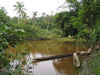
Siberut is the largest and northernmost of the Mentawai Islands, located 150 kilometres west of Sumatra in the Indian Ocean. It covers an area of 3,838.25 km2 including smaller offshore islands, and had a population of 35,091 at the 2010 Census and 40,220 at the 2020 Census; the official estimate as at mid 2023 was 41,899. A part of Indonesia, the island is the most important home for the Mentawai people. The western half of the island was set aside as the Siberut National Park in 1993. Much of the island is covered with rainforest, but is subject to commercial logging.
The pig-tailed langur, monotypic in genus Simias, is a large Old World monkey, endemic to several small islands off the coast of Sumatra in Indonesia. Its face is black, its fur is black-brown and it has a relatively short tail. It is a diurnal species, feeding in the rainforest canopy on leaves, and to a lesser extent, fruit and berries. Little is known of its natural history, but it is heavily hunted, its populations have been declining rapidly and the International Union for Conservation of Nature has assessed its conservation status as being "critically endangered". It has been included on a list of the World's 25 Most Endangered Primates.
The Mentawai Islands rain forests is a tropical moist broadleaf forest ecoregion in Indonesia. It covers the Mentawai Islands, an archipelago in the Indian Ocean off the west coast of Sumatra. The islands have been separated from Sumatra since the mid-Pleistocene period, and their geographic isolation allowed the evolution of several endemic species, including 17 endemic mammals.
Sipora located off Sumatra in the West Sumatra Province of Indonesia, is the second-smallest and most developed of the four Mentawai Islands at only 620.73 km2. It had a population of 17,557 at the 2010 Census and 21,901 at the 2020 Census; the official estimate as at mid 2023 was 23,228. The regency capital of the Mentawai Islands, Tuapejat, is found on Sipora. An estimated 10-15% of the original rainforest remains on this island.
The Mentawai language is an Austronesian language, spoken by the Mentawai people of the Mentawai Islands, West Sumatra, Indonesia.
Siberut National Park comprises 1,905 km2 (47%) of the island of Siberut in the Mentawai Islands of West Sumatra, Indonesia. The whole island including the national park is part of the World Network of Biosphere Reserves.
The Pagai Island macaque, also known as the Pagai macaque or Bokkoi, is an Old World monkey endemic to the Mentawai Islands off the west coast of Sumatra. It is listed as critically endangered on the IUCN Red List due to its ever-shrinking habitat. Macaca pagensis formerly included the overall darker Siberut macaque as a subspecies, but this arrangement is polyphyletic, leading to the two being classified as separate species. Both were formerly considered subspecies of the southern pig-tailed macaque.
The Mentawai macaque or Mentawai island macaque may refer to:
South Pagai is one of the Mentawai Islands of the west coast of Sumatra in Indonesia. The island is south of North Pagai Island. The population figure given for South Pagai refers to South Pagai District alone. The largely unpopulated south portion of Sikakap District covers the northern part of South Pagai Island, as well as various small islands in the strait between the two islands.
The Mentawai langur is a species of primate in the family Cercopithecidae. It is endemic to the Mentawai Islands in Indonesia. Its natural habitat is subtropical or tropical dry forests. The Siberut langur was formerly considered a subspecies of the Mentawai langur.
The September 2007 Sumatra earthquakes were a series of megathrust earthquakes that struck the Sunda Trench off the coast of Sumatra, Indonesia, with three of magnitude 7 or greater. A series of tsunami bulletins was issued for the area. The most powerful of the series had a magnitude of 8.4, which makes it in the top 20 of the largest earthquakes ever recorded on a seismograph.
The Siberut macaque is a vulnerable species of macaque, which is endemic to Siberut Island in Indonesia. It was formerly considered conspecific with the Pagai Island macaque which is overall paler in color, but this arrangement was polyphyletic. Both were formerly considered subspecies of the southern pig-tailed macaque.
The 2010 Mentawai earthquake occurred with a moment magnitude of 7.8 on 25 October off the western coast of Sumatra at 21:42 local time. The earthquake occurred on the same fault that produced the 2004 Indian Ocean earthquake. It was widely felt across the provinces of Bengkulu and West Sumatra and resulted in a substantial localized tsunami that struck the Mentawai Islands.
Sikakap is a sub-district on the Indonesian island of North Pagai, in the Mentawai Islands off Sumatra. The sub-district contains both Sikakap and Matobe, while Sikakap village incorporates the hamlets of Central Sikakap, East Sikakap and Sibaibai. Overall, the total population was 3,194 as of 2016. Also part of the sub-district is the Sikakap Strait between North and South Pagai, a designated Regional Marine Conservation Area. The Strait, an area of 3,960 hectares, has a coastal length of 19.79 kilometres (12.30 mi) and is a major contributor to West Sumatra's fishing industry.
This page is based on this Wikipedia article Text is available under the CC BY-SA 4.0 license; additional terms may apply. Images, videos and audio are available under their respective licenses.