
West Sumatra is a province of Indonesia. It is on the west coast of the island of Sumatra and includes the Mentawai Islands off that coast. West Sumatra borders the Indian Ocean to the west, as well as the provinces of North Sumatra to the north, Riau to the northeast, Jambi to the southeast, and Bengkulu to the south. The province has an area of 42,119.54 km2 (16,262.45 sq mi), with a population of 5,534,472 at the 2020 census. The official estimate at mid 2022 was 5,640,629. The province is subdivided into twelve regencies and seven cities. It has relatively more cities than other provinces outside Java, although several of them are relatively low in population compared with cities elsewhere in Indonesia. Padang is the province's capital and largest city.

Pagaruyung, also known as Pagarruyung, Pagar Ruyung and Malayapura or Malayupura, was a kingdom that once stood in the island of Sumatra and the seat of the Minangkabau kings of Western Sumatra. Modern Pagaruyung is a village in Tanjung Emas subdistrict, Tanah Datar regency, located near the town of Batusangkar, Indonesia.

Pariaman, is a coastal city in West Sumatra, Indonesia. Pariaman covers an area of 73.36 km2 (28 sq mi), with a 12 km (7 mi) coastline. It had a population of 79,043 at the 2010 Census and 94,224 at the 2020 census; the official estimate as at mid 2022 was 96,719 - comprising 48,864 males and 47,855 females. "Pariaman" means "safe area".
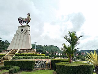
Batusangkar is the capital of the Tanah Datar regency of West Sumatra, Indonesia. It is known as "the city of culture".

Padang Pariaman Regency is a regency (kabupaten) of West Sumatra, Indonesia. It has an area of 1,343.09 km2, and it had a population of 390,204 at the 2010 census and 430,626 at the 2020 census; the official estimate as at mid 2022 was 436,129 - comprising 217,933 males and 218,196 females. The regency seat is at the town of Parit Malintang. West Sumatra's capital and biggest city, Padang, is surrounded on the landward side by this regency.

Pasaman Regency is a regency (kabupaten) of West Sumatra, Indonesia. It has an area of 3,947.63 square kilometres (1,524.19 sq mi) and had a population of 252,981 at the 2010 Census and 299,851 at the 2020 Census; the official estimate as at mid 2022 was 307,425 - comprising 154,712 males and 152,713 females. The regency seat is the town of Lubuk Sikaping.
Solok Regency is an inland regency (kabupaten) of West Sumatra, Indonesia. It covers an area of 3,738 km2 and had a population of 348,566 at the 2010 Census and 391,497 at the 2020 Census; the official estimate as of mid-2022 was 397,829 - comprising 200,218 males and 197,611 females. The administrative centre of the regency is the town of Arosuka, in Gunung Talang District. The city of Solok is administratively separate from the Regency and its area and population are not included in these totals.

Kampar is a regency (kabupaten) of Riau Province of Indonesia. The regency formerly included a much larger part of Riau Province, but on 4 October 1999 the western districts were split off to form a separate Rokan Hulu Regency, and the eastern districts were split off to form a new Pelalawan Regency. It now has an area of 11,289.28 km2 and had a population of 688,204 at the 2010 Census, and 841,332 at the 2020 Census; the official estimate as at mid 2022 was 878,210. The administrative centre of the regency is located at Bangkinang town.
Siak, is a regency (kabupaten) of Riau Province, on the island of Sumatra, Indonesia. It has an area of 8,556.09 km² and had a population of 376,742 at the 2010 Census and 457,940 at the 2020 Census; the official estimate as at mid 2022 was 477,550, comprising 246,186 males and 231,364 females. The administrative centre of the regency is located at Siak Sri Indrapura. The northern part of this regency contains a large part of the Bukit Batu Biosphere Reserve.

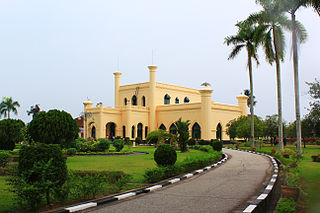
Pagaruyung Palace is the istana of the former Pagaruyung Kingdom, located in Tanjung Emas subdistrict near Batusangkar town, Tanah Datar Regency, West Sumatra, Indonesia. It was built in the traditional Minangkabau Rumah Gadang vernacular architectural style but had several atypical elements including a three-story structure and a larger dimension in comparison to common rumah gadang.

South Labuhanbatu Regency is a regency of North Sumatra Province of Indonesia, created on 21 July 2008 by being carved out of the southern districts of the existing Labuhanbatu Regency. The new South Labuhanbatu Regency covers an area of 3,596 square kilometres and according to the 2010 census it had a population of 277,673, which rose to 314,094 at the 2020 Census; the official estimate as at mid 2023 was 330,797. Its administrative headquarters are at the town of Kotapinang.

Nias Selatan Regency is a regency in North Sumatra province, Indonesia, created on 25 February 2003 by the division of the existing Nias Regency. The regency covers a land area of 2,487.99 square kilometres and according to the 2010 census had a population of 289,708; the 2020 Census showed a population of 360,531, while the official estimate for mid 2023 was 382,539. Its administrative centre is the port of Teluk Dalam. Apart from the southern portion of Nias Island, the regency also includes the smaller Batu Islands to the south, lying between Nias and Siberut; these islands occupy nearly half of the land area of the Regency, but have just 9% of its population.
Ogan Komering Ilir Regency is a regency of South Sumatra Province, Indonesia. It takes its name from the Ogan River and the Komering River, which are the two main rivers that drain the area. The name Ilir means downstream. The administrative centre is the town of Kayu Agung. The regency borders Banyuasin Regency to the northwest, Bangka Strait, and the Java Sea to the east, Lampung Province to the south, and Palembang city, Ogan Ilir Regency, and East Ogan Komering Ulu Regency to the west.

Tulang Bawang Regency is a regency (kabupaten) of Lampung Province, Sumatra, Indonesia. The regency was created on 3 January 1997 from the eastern half of North Lampung Regency; when created, it originally covered a much wider area, but on 29 October 2008 the 7 northern districts were separated off to form a new Mesuji Regency, and the 8 western districts were also separated off to form a new West Tulang Bawang Regency. It now has an area of 3,466.32 square kilometres (1,338.35 sq mi) and had a population of 397,906 at the 2010 Census and 430,021 at the 2020 Census; the official estimate as at mid 2022 was 431,208. The regency seat is the town of Menggala, located about 120 kilometres (75 mi) from the provincial capital of Bandar Lampung. The regency takes its name from the Tulang Bawang River which flows through the province.

West Tulang Bawang Regency is a regency (kabupaten) of Lampung Province, Sumatra, Indonesia. It was created on 29 October 2008 from what were formerly the western districts of Tulang Bawang Regency. It has an area of 1,201.15 km2 and had a population of 250,707 people at the 2010 Census and 286,162 at the 2020 Census; the official estimate as at mid 2022 was 289,620. The regency seat is the town of Panaragan Jaya.

Tour de Singkarak is an annual professional road bicycle racing stage race held in West Sumatra, Indonesia, and named after the Lake Singkarak. First staged in 2009, Tour de Singkarak is classified by the Union Cycling International (UCI) as a 2.2 category race as part of the UCI Asia Tour. It covers more than 1267 kilometres — from/to Padang passing around lake Singkarak and runs through inland West Sumatran cities — and lasted for a week and held annually. This exciting tour across the picturesque West Sumatra countryside's scenic landscapes, comprising beaches, blue lakes, and numerous hairpin bends, as they climb up to the foot of the volcanoes. The total prize money is IDR 1,000,000,000 (US$100,000). BNI-Maybank was the platinum sponsor of the Tour De Singkarak since 2009 with the Ministry of Culture and Tourism of Indonesia. TDS is the biggest international cycling race in Indonesia, having the fifth largest audience in the world, it attracted many top international cyclists to participate in this world famous annual sports event.

Jamik Sungai Jambu Mosque is one of the oldest mosques in Indonesia located in Jorong Sungai River, Sungai Jambu Nagari, Pariangan District, Tanah Datar Regency, West Sumatra. The mosque was built in 1918 at the foot of Mount Marapi, and during its development it has experienced a number of improvements both in terms of outlook and management. The mosque had ranked first for several times including in 2012, in the assessment of environmentally-oriented mosques for the provincial level which is conducted by the Indonesian Mosque Council.

The pacu jawi is a traditional bull race in Tanah Datar, West Sumatra, Indonesia. In the race, a jockey stands on a wooden plough loosely tied to a pair of bulls and holds them by their tails while the bulls cover about 60–250 metres (200–820 ft) of muddy track in a rice field. Although the name means a "bull race", the bulls do not directly compete against each other, and no formal winner is declared. Instead, spectators judge the bulls by their performance, and have the ability to buy well-performing bulls, albeit at well above usual price. The people of Tanah Datar—especially the nagaris (villages) in four of its districts—have been conducting this tradition for centuries to celebrate the end of the rice harvest. The race is held concurrently with a village festival of culture called alek pacu jawi. Recently it has become a tourist attraction supported by the government and the subject of multiple award-winning photographs.
Atar is a nagari (village) in Padang Ganting, Tanah Datar Regency, in the Indonesian province of West Sumatra, with a population of just under 5,000 people.
Marawa is a tricolour flag that consists of three vertical charts that feature the colours of the Minangkabau culture: black, red, and gold. It is not known for sure when this flag was first used, but it was officially adopted as the flag of the Pagaruyung Kingdom since its founding in 1347. This flag was also adopted by other kingdoms of the Minangkabau rantau such as the Inderapura Kingdom. A derivative of the flag is also currently used by Negeri Sembilan, a state in Malaysia with historical and cultural connections with the kingdom.


