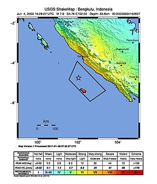
At 23:28 local time on June 4, 2000, southern Sumatra, Indonesia was struck by an earthquake of moment magnitude 7.9 with a maximum Mercalli intensity of VI (Strong). The event occurred off the coast near Enggano Island. There were more than 100 fatalities and up to 2,585 injuries. Over 730 aftershocks shook the area afterwards, one just eleven minutes after the mainshock.

The 2009 Dusky Sound earthquake was a 7.8 earthquake that struck a remote region of Fiordland, New Zealand, on 15 July at 21:22 local time. It had an initially–reported depth of 12 km (7.5 mi), and an epicentre near Dusky Sound in Fiordland National Park, which is 160 km (99 mi) north-west of Invercargill. It was the country's largest earthquake magnitude since the 1931 Hawke's Bay earthquake, but caused only minor damage and there were no casualties. A tsunami accompanied the event and had a maximum measured run-up of 230 cm (91 in).

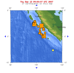
The first of the 2009 Sumatra earthquakes occurred on 30 September off the coast of Sumatra, Indonesia with a moment magnitude of 7.6 at . The epicenter was 45 kilometres (28 mi) west-northwest of Padang, West Sumatra, and 220 kilometres (140 mi) southwest of Pekanbaru, Riau. Government and authorities confirmed 1,115 dead, 1,214 severely injured and 1,688 slightly injured. The most deaths occurred in the areas of Padang Pariaman (675), Padang (313), Agam (80) and Pariaman (37). In addition, around 135,000 houses were severely damaged, 65,000 houses were moderately damaged and 79,000 houses were slightly damaged. An estimated 250,000 families have been affected by the earthquake through the total or partial loss of their homes and livelihoods.

The 2010 Mentawai earthquake occurred with a moment magnitude of 7.8 on 25 October off the western coast of Sumatra at 21:42 local time. The earthquake occurred on the same fault that produced the 2004 Indian Ocean earthquake. It was widely felt across the provinces of Bengkulu and West Sumatra and resulted in a substantial localized tsunami that struck the Mentawai Islands.
The 2012 Indian Ocean earthquakes were magnitude 8.6 and 8.2 Mw undersea earthquakes that struck near the Indonesian province of Aceh on 11 April at 15:38 local time. Initially, authorities feared that the initial earthquake would cause a tsunami and warnings were issued across the Indian Ocean; however, these warnings were subsequently cancelled. These were unusually strong intraplate earthquakes and the largest strike-slip earthquake ever recorded.
The 2014 Iquique earthquake struck off the coast of Chile on 1 April, with a moment magnitude of 8.2, at 20:46 local time. The epicenter of the earthquake was approximately 95 kilometres (59 mi) northwest of Iquique. The mainshock was preceded by a number of moderate to large shocks and was followed by a large number of moderate to very large aftershocks, including a M7.7 event on 3 April. The megathrust earthquake triggered a tsunami of up to 2.11 metres (6.9 ft) that hit Iquique at 21:05 local time. Similar-sized tsunamis were also reported to have hit the coasts of Pisagua and Arica.

The 2016 Sumatra earthquake was a 7.8 magnitude earthquake which struck on 2 March 2016 in the Indian Ocean, approximately 800 kilometers southwest of Sumatra in Indonesia. Tsunami warnings were issued for Indonesia and Australia, but were withdrawn two hours later. There were no deaths directly related to the earthquake.
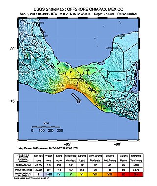
The 2017 Chiapas earthquake struck at 23:49 CDT on 7 September in the Gulf of Tehuantepec off the southern coast of Mexico near the state of Chiapas, approximately 87 kilometres (54 mi) southwest of Pijijiapan, with a Mercalli intensity of IX (Violent). The moment magnitude was estimated to be 8.2.

On January 23, 2018, at 00:31 AKST, an earthquake occurred in the Gulf of Alaska near Kodiak Island. The earthquake, measured at 7.9 on the scale, was approximately 280 kilometers (170 mi) southeast of Kodiak and happened at a depth of 25 kilometers (16 mi).

At 2:10 p.m. local time (UTC-5) on 28 January 2020, an earthquake of 7.7 struck on the north side of the Cayman Trough, north of Jamaica and west of the southern tip of Cuba, with the epicenter being 80 miles (130 km) ESE of Cayman Brac, Cayman Islands or 83 miles (134 km) north of Montego Bay, Jamaica. Schools in Jamaica and buildings in Miami were evacuated after shaking was observed in parts of the U.S. state of Florida. Light shaking was also reported on the Yucatan peninsula in Mexico. It is the largest earthquake in the Caribbean since 1946. A tsunami warning for the Caribbean Sea was issued by the Pacific Tsunami Warning Center and later withdrawn.
An earthquake struck the Mexican state of Oaxaca at 10:29 local time on June 23, 2020, with a magnitude of 7.4 . The epicenter was 19 miles (31 km) from San Miguel del Puerto and 7.5 miles (12.1 km) south-southwest of Santa María Zapotitlán. The quake was felt by an estimated 49 million people in Mexico and Guatemala, with some tremors felt as far away as 640 kilometers (400 mi). Thousands of houses in Oaxaca were damaged and 10 deaths were reported. A tsunami warning was issued for southern Mexico, El Salvador, Guatemala, and Honduras.

On 9 December 2016 at 4:38 a.m. local time, the Solomon Islands region was rocked by an Mww 7.8 earthquake, centred 30 km off San Cristobal Island, about 61 km southwest of Kirakira, the capital of Makira-Ulawa Province. Initially registering magnitude 8.0, later downgraded to 7.8, the temblor prompted tsunami warnings that kept countries surrounding the Coral, Tasman and Solomon Sea on high alert, but was later cancelled. A large aftershock of magnitude 6.9 occurred shortly afterwards. This earthquake was largely felt, waking many residents who later ran to high ground for fears of a potential tsunami. The earthquake killed a child and affected some 34,000 people in Makira, South Malaita and Guadalcanal Island where many had lost their homes or had no access to basic needs. Earthquakes are common in this region, with little or no fatalities. This earthquake is tied with three other magnitude 7.8 earthquakes for the second largest earthquake of 2016. On 17 December, Solomon Islands would be rattled again by a 7.9 magnitude earthquake, this time 54 km east of Taron, Papua New Guinea.

The 2013 Craig, Alaska earthquake struck on January 5, at 12:58 am (UTC–7) near the city of Craig and Hydaburg, on Prince of Wales Island. The Mw 7.5 earthquake came nearly three months after an Mw 7.8 quake struck Haida Gwaii on October 28, in 2012. The quake prompted a regional tsunami warning to British Columbia and Alaska, but it was later cancelled. Due to the remote location of the quake, there were no reports of casualties or damage.

On February 20, 2008, an earthquake with a moment magnitude of 7.4 struck off the coast of Sumatra at a hypocentre depth of 26 km. The earthquake had an epicenter located on the island of Simeulue, northwest from Sinabang, a small town on the island. Three people were killed and an additional 25 seriously injured as a result of the earthquake.
The 2021 Kermadec Islands earthquakes were a series of earthquakes with magnitudes of 8.1 and 7.4 that occurred at 19:28:31 UTC on 4 March 2021. The epicentres were located southeast of Raoul Island in the Kermadec Islands, part of the New Zealand outlying islands. The main magnitude 8.1 earthquake was preceded by a magnitude 7.4 foreshock and followed by a magnitude 6.1 aftershock. A separate, unrelated magnitude 7.3 earthquake occurred off the coast of the North Island of New Zealand, approximately 900 km to the south, several hours before the main quakes. More than a dozen aftershocks exceeded magnitude 6.

An earthquake occurred off the coast of the Alaska Peninsula on July 28, 2021, at 10:15 p.m. local time. The large megathrust earthquake had a moment magnitude of 8.2 according to the United States Geological Survey (USGS). A tsunami warning was issued by the National Oceanic and Atmospheric Administration (NOAA) but later cancelled. The mainshock was followed by a number of aftershocks, including three that were of magnitude 5.9, 6.1 and 6.9 respectively.
The 2021 South Sandwich Islands earthquakes were a pair of powerful earthquakes, followed by many strong aftershocks which struck along the South Sandwich Trench in August 2021. The quakes measured 7.5 and 8.1 on the moment magnitude scale, according to the United States Geological Survey. The mainshock is tied with another event in 1929 as the largest earthquake ever recorded in the South Atlantic region, and is tied with the 2021 Kermadec Islands earthquake as the second largest earthquake of 2021.

An earthquake occurred 112 km, offshore, north of Maumere in the Flores Sea on 14 December. The quake had a moment magnitude of 7.3 according to the United States Geological Survey (USGS). One person was killed and 173 others suffered injuries.
The 1843 Nias earthquake off the northern coast of Sumatra, Indonesia caused severe damage when it triggered a tsunami along the coastline. The earthquake with a moment magnitude (Mw ) of 7.8 lasted nine minutes, collapsing many homes in Sumatra and Nias. It was assigned a maximum modified Mercalli intensity of XI (Extreme).
The 1933 Sumatra earthquake or Liwa earthquake occurred in West Lampung Regency, Lampung Province, Indonesia on June 25. The earthquake had an estimated surface-wave magnitude (Ms ) of 7.7 occurring at a shallow depth of 20 km. It had an epicenter onshore, devastating the city of Liwa. At least 788 people were reported killed, although the death toll may have been in the thousands. Aftershocks followed, including one which was strong enough to cause additional fatalities. The mainshock also triggered a nearby volcanic eruption two weeks later, killing some people.