Southern Thailand

Last updated
Southern Region
Paktai (ปักษ์ใต้)
Sunrise thailand ko samui.jpg
TaRuTao11.jpg
Wat phra mahathat woramahawihan nakhon si thammarat.jpg
Khao Sok National Park Surat Thani Province, Thailand.jpg
Phuket, April 2012.jpg
From upper-left to lower-right: Sunrise Thailand Ko Samui, Tarutao National Park, Wat Phra Mahathat Woramahawihan, Rajjaprabha Dam and Phuket City.
Thailand South.png
Southern Region in Thailand
Largest city Hat Yai
Provinces
Area
[1]
  Total73,848 km2 (28,513 sq mi)
Population
 (2018) [2]
  Total9,454,193
  Density134/km2 (350/sq mi)
Demonym Southern Thai
GDP
[3]
  TotalUS$45.6 billion (2019)
Time zone UTC+07:00 (ICT)
Language Southern ThaiPattani MalaySatun MalayMosUrak Lawoi'MoklenHokkien etc.

Southern Thailand, Southern Siam or Tambralinga is a southernmost cultural region of Thailand, separated from Central Thailand region by the Kra Isthmus.

Contents

Geography

Khao Sok National Park, Surat Thani Cheow Lan Lake, Khao Sok, Thailand.jpg
Khao Sok National Park, Surat Thani

Southern Thailand is on the Malay Peninsula, with an area of around 70,714 km2 (27,303 sq mi), bounded to the north by Kra Isthmus, the narrowest part of the peninsula. The western part has highly steep coasts, while on the east side river plains dominate. The largest river of the south is the Tapi in Surat Thani, which together with the Phum Duang in Surat Thani drains more than 8,000 km2 (3,100 sq mi), more than 10 percent of the total area of southern Thailand. Smaller rivers include the Pattani, Saiburi, Krabi, and the Trang. The biggest lake of the south is Songkhla Lake (1,040 km2 (400 sq mi) altogether). The largest artificial lake is the Chiao Lan (Ratchaprapha Dam), occupying 165 km2 (64 sq mi) of Khao Sok National Park in Surat Thani. The total forest area is 17,964 km2 (6,936 sq mi) or 24.3 percent of provincial area. [1]

Ko Lao Liang Phi LaoLiangPhi.jpg
Ko Lao Liang Phi

Running through the middle of the peninsula are several mountain chains, with the highest elevation at Khao Luang, 1,835 m (6,020 ft), in Nakhon Si Thammarat Province. Ranging from the Kra Isthmus to Phuket Island is the Phuket chain, which connects to the Tanao Si Mountain Range further north. Almost parallel to the Phuket chain, but 100 km (60 mi) to the east is the Nakhon Si Thammarat or Banthat chain, which begins with Samui Island, Ko Pha Ngan, and Ko Tao in Surat Thani Province and ends at the Malaysian border at the Ko Ta Ru Tao archipelago. The border with Malaysia is formed by the Sankalakhiri range, sometimes sub-divided into the Pattani, Taluban, and Songkhla chain. At the Malaysian border the Titiwangsa chain rises up.

The limestone of the west coast has been eroded into many steep singular hills. The parts submerged by the rising sea after the last ice age now form many islands, like the well-known Phi Phi Islands.[ citation needed ] Also well known is the so-called James Bond Island in Phang Nga Bay, featured in the movie The Man with the Golden Gun .

The population of the growing region is projected to be 9,156,000 in 2015, up from 8,871,003 in 2010 (census count and adjusted), despite these figures are adjusted for citizens who have left for Bangkok or who have moved to the region from elsewhere, as well as registered permanent residents (residency was problematic in the prior 2000 census), the figure is still misleading.[ citation needed ] There are still a huge number of migrant or informal workers, temporary workers, and even stateless people, and a large expatriate population which is not included. [4]

Most of Southern Thailand is in Tenasserim-South Thailand semi-evergreen rain forests ecoregion. The Peninsular Malaysian rain forests and Peninsular Malaysian montane rain forests ecoregions extend into southernmost Thailand along the border with Malaysia. [5]

History

Wat Phra Baromathat, Nakhon Si Thammarat, an old and important temple Nakhon Si Thammarat Chedi Phra Baromathat.jpg
Wat Phra Baromathat, Nakhon Si Thammarat, an old and important temple
Pagoda in Javanese or Sailendran-style, Chaiya, Surat Thani Borom That Chaiya.jpg
Pagoda in Javanese or Sailendran-style, Chaiya, Surat Thani
Malay Muslim provinces in Southern Thailand and northern Malaysia. MalaysiaThailand (en).png
Malay Muslim provinces in Southern Thailand and northern Malaysia.

The Malay peninsula has been settled since prehistoric times. Archeological remains were found in several caves, some used for dwellings, others as burial sites. The oldest remains were found in Lang Rongrien Cave, dating 38,000 to 27,000 years before present, and in the contemporary Moh Khiew cave.

In the first millennium Chinese chronicles mention several coastal cities or city-states. No exact geographical locations were recorded, so the identification of these cities with later settlements is difficult. The most important of these states were Langkasuka, usually considered a precursor of the Patani Kingdom; Tambralinga, probably the precursor of the Nakhon Si Thammarat Kingdom, or P'an-p'an in Phunphin district, Surat Thani, probably located at the Bandon Bay Tapi River. The cities were highly influenced by Indian culture, and have adopted Brahman or Buddhist religion. When Srivijaya in Chaiya extended its sphere of influence, those cities became tributary states of Srivijaya. The city Chaiya in Surat Thani Province contains several ruins from Srivijaya times, and was probably a regional capital of the kingdom. Some Thai historians even claim that it was the capital of the kingdom itself for some time, but this is disputed.

After Srivijaya lost its influence, Nakhon Si Thammarat became the dominant kingdom of the area. During the rule of King Ramkhamhaeng the Great of Sukhothai, Thai influence first reached Nakhon Si Thammarat. According to the Ramkhamhaeng inscription, Nakhon Si THammarat was a tributary state of Sukhothai. During most of later periods, Nakhon became a tributary of Ayutthaya.

The deep south belonged to the Malay sultanates of Pattani and Kedah, while the northernmost part of the peninsula was under the control of Bangkok.

During the Thesaphiban reforms at the end of the 19th century, both Nakhon Si Thammarat and Pattani were incorporated into the central state. The area was subdivided into 5 monthon , which were installed to control the city states ( mueang ). Minor mueang were merged into larger ones, thus forming the present 14 provinces. With the Anglo-Siamese Treaty of 1909 the boundary to Malaysia was fixed. Kedah came under British control, while Pattani stayed with Siam.

Languages

The largest native language is Southern Thai (Thai : ภาษาไทยใต้ [pʰaːsǎːtʰajtâːj] ), also known as Pak Thai or Dambro (Thai : ภาษาตามโพร [pʰaːsǎːtaːmpʰroː] ), which is a southwestern Tai language spoken in the 14 changwat of southern Thailand as well as by small Thai communities in the northernmost Malaysian states. It is spoken natively by roughly five million people and as a second language by the 1.5 million native speakers of Patani Malay, along with other ethnic groups such as the local Negritos communities, and other tribal groups.[ citation needed ]

Although Central Thai is the sole official language in Thailand and most people are able to communicate in Central Thai, the language is only the third largest native language in Southern Thailand, with roughly four hundred thousand native speakers. In particular, it is only native among Teochew, Hoklo, Hakka and Cantonese ethnic groups, particularly in their major ethnic enclaves like Hat Yai and Bandon districts; their dialect is very similar to the Krungthep dialect (upper class dialect in Bangkok), seasoned with some Southern Thai loanwords.

Administrative divisions

Thailand Southern provinces.png

The Office of the National Economic and Social Development Council (NESDC) identities Southern Thailand as 14 provinces. [6]
The Thai Meteorological Department (TMD) includes for Southern Thailand (east coast) also the two provinces: Prachuap Khiri Khan and Phetchaburi. [7]

 Name Thai Area Pop. [2] Dens.Annual
income
Poverty
Ratio
Coastal
region
1Chumphon Flag.png  Chumphon ชุมพร6,009.0510,96385351,6725.4%East
2Nakhon Si Thammarat Flag.svg  Nakhon Si Thammarat นครศรีธรรมราช9,942.51,560,433157301,4888.1%East
3Flag Naratiwat Province.png  Narathiwat นราธิวาส4,475.0802,474179238,68037.3%East
4Pattani Flag.png  Pattani ปัตตานี1,940.4718,077370210,15636.0%East
5Phattalung provincial flag .png  Phatthalung พัทลุง3,424.5525,044153257,73614.0%East
6Flag Songkhla Province.png  Songkhla สงขลา7,393.91,432,628194331,9208.2%East
7Flag Surat Thani Province.png  Surat Thani สุราษฎร์ธานี12,891.51,063,50183437,5921.4%East
8Yala Flag 2.png  Yala ยะลา4,521.1532,326118187,00821.2%East
9Flag of Krabi Province.jpg  Krabi กระบี่4,709.0473,738101372,1326.4%West
10Phangnga Flag.png  Phang Nga พังงา4,170.0268,24064346,1045.1%West
11Phuket Flag.png  Phuket ภูเก็ต543.0410,211755378,0000.5%West
12Flag Ranong Province.png  Ranong ระนอง3,298.0191,86858264,42016.6%West
13Satun Flag.png  Satun สตูล2,479.0321,574130278,4965.8%West
14Trang Flag.png  Trang ตรัง4,917.5643,116131279,70815.9%West
Average household annual income in 2015 (Thai baht). [8]
Poverty Ratio in 2016. [9]

Demography

Southern Thailand has 9.454 million inhabitants and its population density is 134 per square kilometre (350/sq mi). [2]

Ten major cities of southern Thailand

No.Name Pop. Metropolitan
1 Hat Yai 159,627397,379 in Hat Yai District.
2 Surat Thani 130,114177,242 in Mueang Surat Thani District.
3 Nakhon Si Thammarat 104,948271,330 in Mueang Nakhon Si Thammarat District.
4 Phuket 78,923238,866 in Mueang Phuket District.
5 Ko Samui 65,84782,900 in Ko SamuiKo Pha Ngan.
6 Songkhla 64,602163,083 in Mueang Songkhla District.
7 Yala 61,293167,582 in Mueang Yala District.
8 Trang 59,999156,115 in Mueang Trang District.
9 Pattani 44,900130,178 in Mueang Pattani District.
10 Narathiwat 41,572124,049 in Mueang Narathiwat District.

Religion

Religion in Southern Thailand (2015 census) [10]

   Buddhism (75.45%)
   Islam (24.33%)
   Christianity (0.21%)
   Sikhism (0.005%)
  Other religions (0.004%)
  No religion (0.008%)

Thailand is a Buddhist majority country. About 93.46% in Thailand follow Buddhism. [11] Buddhism is the majority religion in Southern Thailand as well. However, Buddhism makes up only 75.45% in Southern Thailand. [10] Thai people follow Theravada Buddhism. Minority ethnic groups such as Khmer also follow Buddhism. 10 out of 14 provinces in Southern Thailand have Buddhist majorities.
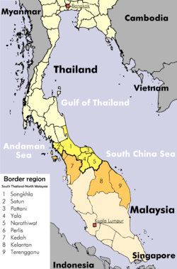
Islam constitutes 24.33% of Southern Thailand even though Islam only constitutes 5.36% of the whole country. [10] Islam is mostly followed by Malay people in Southernmost Thailand. There's also a small Thai Muslim population. Islam is the majority religion in the Malay majority in Yala, Pattani, Naratiwat and Satun provinces near Malaysia known as Southernmost Thailand.

Christianity makes up 0.21% of Southern Thailand population. Sikhism makes up 0.05% in Southern Thailand. Sikhism is followed by Indian immigrants. [10]

Economy

The bulk of the southern population relies on agriculture for 27 percent of its gross regional product in 2014. It is followed by industry (12 percent), trade (10 percent), transportation (9 percent), tourism (8 percent), and construction and property (7 percent). [12] For FY 2018, Southern Thailand Region had a combined economic output of 1,402 trillion baht (US$45.2 billion), or 8.6 percent of Thailand's GDP. Surat Thani province had an economic output of 206.869 billion baht (US$6.67 billion). This equates to a GPP per capita of 182,371 baht (US$5,883), more than double for Yala province, which is fifth and more than three times for Narathiwat province, lowest in the ranking. [13]

Gross Provincial Product (GPP)
RankProvinceGPP
(million baht)
Population
(x 1000)
GPP per capita (baht)
1Surat Thani206,8691,134182,371
2Chumphon87,746498176,200
3Songkhla248,3861,635151,918
4Nakhon Si Thammarat164,3751,507109,050
5Yala43,00646891,815
6Pattani48,54964175,697
7Phatthalung36,00649273,213
8Narathiwat44,77872162,066
 East coast879,7157,096123,973
Gross Provincial Product (GPP)
RankProvinceGPP
(million baht)
Population
(x 1000)
GPP per capita (baht)
1Phuket234,028580403,534
2Phang-nga78,493250313,919
3Krabi86,684418207,415
4Satun31,215290107,505
5Ranong28,014269103,966
6Trang64,586630102,589
 West coast523,0202,437214,616

Transportation

Southern Thailand is connected with Bangkok by railway as well as highway. Several regional airports are located at the larger towns. The transportation hub of all south Thailand is Hat Yai.

Road

Phetkasem Road is the longest road in Thailand, running from Bangkok along the Kra Isthmus and then along the west coast of the peninsula. From Trang it crosses over to the east coast to Hat Yai, and ends at the Malaysian border.

Two Asian highways run through Southern Thailand: Asian Highway 2 runs mostly parallel to the railroad all the way from Bangkok. It crosses to Malaysia at Sadao, and continues on the west side of the peninsula. Asian Highway 18 begins in Hat Yai and runs south along the east coast, crossing to Malaysia at Sungai Kolok.

Ko Samui Airport Samui Airport Departure Gate.jpg
Ko Samui Airport
Ko Samui Airport runway Samui Airport Runway.jpg
Ko Samui Airport runway
Hat Yai Airport HDY parking.jpg
Hat Yai Airport

Rail

The southern railway connects Bangkok to Hat Yai, and continues from there to Sungai Kolok. There are branches from Ban Thung Phoe Junction to Kirirat Nikhom. Two smaller branches of the railway run from Thung Song to Trang and Nakhon Si Thammarat, and from Hat Yai Junction to Malaysia and Singapore.

Air

Southern Thailand has five international airports and six domestic airports. As of 2018 Thailand's transport ministry is constructing the 1.9 billion baht Betong Airport. It is scheduled for completion in 2020. [14]

See also

Related Research Articles

<span class="mw-page-title-main">Surat Thani province</span> Largest province of Thailand

Surat Thani, often shortened to Surat, is the largest of the southern provinces (changwat) of Thailand. It lies on the western shore of the Gulf of Thailand. Surat Thani means 'city of good people', a title given to the city by King Vajiravudh ; Surat Thani is therefore the sole province in Southern Thailand for which the native name is in the Central Thai language.

<span class="mw-page-title-main">Trang province</span> Province of Thailand

Trang, also called Mueang Thap Thiang, is one of the southern provinces (changwat) of Thailand, on the west side of the Malay Peninsula facing the Strait of Malacca. Neighboring provinces are Krabi, Nakhon Si Thammarat, Phatthalung, and Satun.

<span class="mw-page-title-main">Krabi province</span> Province of Thailand

Krabi is a province (changwat) of southern Thailand, on the shore of the Andaman Sea. Neighbouring provinces are Phang Nga, Surat Thani, Nakhon Si Thammarat, and Trang. Phuket province lies to the west across Phang Nga Bay. Krabi town is the seat of the provincial government.

<span class="mw-page-title-main">Nakhon Si Thammarat province</span> Province of Thailand

Nakhon Si Thammarat province is a province (changwat) of Thailand, on the western shore of the Gulf of Thailand. As of 2018, it was the most populous province of Southern Thailand, with a population of approximately 1.5 million. Neighboring provinces are Songkhla, Phatthalung, Trang, Krabi and Surat Thani.

<span class="mw-page-title-main">Songkhla province</span> Province of Thailand

Songkhla is one of the southern provinces (changwat) of Thailand. Neighboring provinces are Satun, Phatthalung, Nakhon Si Thammarat, Pattani, and Yala. To the south it borders Kedah and Perlis of Malaysia.

<span class="mw-page-title-main">Satun province</span> Province of Thailand

Satun (Thai: สตูล, pronounced[sā.tūːn] is one of the southern provinces of Thailand. Neighboring provinces are Trang, Phatthalung, and Songkhla. To the south it borders Perlis of Malaysia.

Thai Airways Company or Thai Airways was the domestic flag carrier of Thailand. Its main base was the domestic terminal at Don Mueang International Airport. Its head office was located in Pom Prap Sattru Phai, Bangkok. In 1988, Thai Airways merged to become Thai Airways International.

Southern Thai, also known as Dambro, Pak Tai, or "Southern language", is a Southwestern Tai ethnolinguistic identity and language spoken in southern Thailand as well as by small communities in the northernmost Malaysian states. It is spoken by roughly five million people, and as a second language by the 1.5 million speakers of Pattani and other ethnic groups such as the local Peranakans communities, Negritos, and other tribal groups. Most speakers are also fluent in or understand the Central Thai dialects.

<span class="mw-page-title-main">State Railway of Thailand</span> State-owned rail operator of Thailand

The State Railway of Thailand (SRT) is the state-owned rail operator under the jurisdiction of the Ministry of Transport in Thailand.

<span class="mw-page-title-main">Surat Thani railway station</span> Railway station in Thailand

Surat Thani railway station is the main railway station in Surat Thani Province, Thailand. It is on the State Railway of Thailand's Southern Line, located 635.106 km from Thon Buri railway station. The station is on the eastern bank of the Tapi River in Tha Kham town, Phun Phin District. Surat Thani Station first opened in 1915, and was originally named Phun Phin Station. The name was later changed to "Surat Thani railway station".

<span class="mw-page-title-main">Highway 401 (Thailand)</span>

Highway 401 is a national highway in Southern Thailand. It starts from the west coast of the Thai-Malay Peninsula at an intersection with Phetkasem Road near Amphoe Takua Pa, Phang Nga Province.

The 2010 Regional League Division 2 was contested by the five regional league winners and runners up of the 3rd level championships of Thailand. The two best 3rd placed teams from the regional leagues also take part

The 2012 Regional League Division 2 was contested by the five regional league winners and runners up of the 3rd level championships of Thailand. The two best 3rd placed teams from the regional leagues also take part

<span class="mw-page-title-main">Southern Line (Thailand)</span> Railway line in Thailand

Southern Line is a metre-gauge railway line in Thailand, operated by State Railway of Thailand (SRT), which runs through most of the provinces in the Central, Western, and Southern regions of Thailand. At 1,144.29 kilometres in length, it is Thailand's longest railway line.

Pattani railway station or Pattani railway station is a railway station located in Khok Pho Subdistrict, Khok Pho District, Pattani. It is a class 1 railway station located 1,009.209 km (627.1 mi) from Thon Buri Railway Station. The station opened in April 1917 as Khok Pho Station, as part of the Southern Line section between U Taphao Junction -Khlong Sai. The line extended further south, terminating at Su-ngai Kolok in September 1921, where it linked up with the Malaysian railway.

The 2017 Southern Thailand floods are the biggest floods in over 30 years in the southern part of the country during the regional annual monsoon season, which is distinct from other parts of the nation and mirrors that the Malay Peninsula. Between December 2016 and January 2017, Southern Thailand experienced a devastating flood disaster. The bulk of the 15 provinces in Southern Thailand were affected, and this flood event stood out from earlier flood catastrophes due to the massive, long-term damage it produced. Since around December 31, 2016, there have been abnormally significant rains for that time of year. According to the Meteorological Department, thunderstorms and strong winds continued to affect the southern regions. The amount of water in the Nan River, which flows through the Taphan Hin and Bang Mun Nak districts of the capital city of Phichit Province, rose at an alarming rate. This is the second deadly flood in a month in southern Thailand. The Department of Disaster Prevention and Mitigation (DDPM) of the Ministry of Interior estimates that there were 95 fatalities and 1,815,618 total victims in the 13 prefectures that were affected by the disaster. 4,314 road segments, 348 bridges, 126 weirs, and 2 sluices were among the destroyed infrastructure items. The extensive area of heavy rain and the simultaneous occurrence of numerous dam breaks severely damaged the local logistics infrastructure. While gum and palm oil help some regions' economies, others, like the extremely underdeveloped territory bordering Malaysia, are socioeconomically unstable. In these situations, the government made efforts in disaster restoration works by utilizing the military in a way that had never before been done for this purpose. Some 120 billion baht in damages are foreseen as of mid-January, much of this due to lost production in agriculture tourism and infrastructure. Rubber supply is particularly impacted. Particularly hard hit are palm and rubber plantations.

<span class="mw-page-title-main">Department of Airports (Thailand)</span> Government Agency

The Department of Airports (DOA) is a Thai government department under the Ministry of Transport. It operates 28 civil airports throughout the country. The department was split off from the Department of Civil Aviation in 2015, part of a restructuring response to ICAO's downgrading of Thailand's aviation safety rating. The other agency that previously formed part of the old department is the Civil Aviation Authority of Thailand.

<span class="mw-page-title-main">5th Infantry Division (Thailand)</span> Special operations force of the Royal Thai Army

The 5th Infantry Division (พล.ร.๕.) is an infantry division of the Royal Thai Army, it is currently a part of the Fourth Army Area. The unit is composed of the 5th Infantry Regiment, 15th Infantry Regiment and 25th Infantry Regiment.

<span class="mw-page-title-main">Provincial Electricity Authority</span>

The Provincial Electricity Authority (PEA) is a Thai state enterprise under the Ministry of Interior. Established on 28 September 1960 by the Provincial Electricity Authority Act 1960 —which are served by the Metropolitan Electricity Authority.

References

  1. 1 2 "ตารางที่ 2 พี้นที่ป่าไม้ แยกรายจังหวัด พ.ศ.2562" [Table 2 Forest area Separate province year 2019]. Royal Forest Department (in Thai). 2019. Retrieved 6 April 2021, information, Forest statistics Year 2019.
  2. 1 2 3 "รายงานสถิติจำนวนประชากรและบ้านประจำปี พ.ศ.2561" [Statistics, population and house statistics for the year 2018]. Registration Office Department of the Interior, Ministry of the Interior (in Thai). 31 December 2018. Archived from the original on 14 June 2019. Retrieved 20 June 2019.
  3. "Gross Regional and Provincial Product, 2019 Edition". <>. Office of the National Economic and Social Development Council (NESDC). July 2019. ISSN   1686-0799 . Retrieved 22 January 2020.
  4. "Thailand: Major Cities, Towns & Communes - Population Statistics, Maps, Charts, Weather and Web Information".
  5. Wikramanayake, Eric; Eric Dinerstein; Colby J. Loucks; et al. (2002). Terrestrial Ecoregions of the Indo-Pacific: a Conservation Assessment. Washington, DC: Island Press.
  6. "Revisions to the Gross Regional and Provincial Product 2016 Edition". nesdb.go.th. The Office of the National Economic and Social Development Board (NESDB). July 2018. Retrieved 26 December 2019. page 35 The South
  7. "Weather - Southern-east coast". tmd.go.th. Thai Meteorological Department. 2019. Retrieved 26 December 2019.
  8. ดัชนีความก้าวหน้าของคน ปี2560 [Human Achievement Index - HAI year 2017](PDF). social.nesdb.go.th (Report) (in Thai). National Economic and Social Development Board (NESDB). 2017. pp. 149–165. ISBN   978-974-9769-33-1 . Retrieved 14 September 2019, sub 5.64-5.77 section: Average household income per month{{cite report}}: CS1 maint: postscript (link)
  9. ดัชนีความก้าวหน้าของคน ปี2560 [Human Achievement Index - HAI year 2017](PDF). social.nesdb.go.th (Report) (in Thai). National Economic and Social Development Board (NESDB). 2017. pp. 149–165. ISBN   978-974-9769-33-1 . Retrieved 14 September 2019, sub 5.64-5.77 section: Poverty Ratio{{cite report}}: CS1 maint: postscript (link)
  10. 1 2 3 4 "Population by religion, region and area, 2015" (PDF). NSO. Retrieved 10 January 2018.
  11. "Population by religion, region and area, 2018". NSO. Retrieved 9 March 2021.
  12. Wangkiat, Paritta (25 August 2017). "Songkhla power plant sit-in an energy wake-up call". Bangkok Post. Retrieved 25 August 2017.
  13. Phitsanulok Provincial Statistical Report 2562-2019: Economic Statistics - National Accounts. Phitsanulok Provincial Statistical Office (Report). National Statistical Office (NSO). 2020. pp. 96–97. ISSN   1905-8314.
  14. Sritama, Suchat (27 August 2018). "Better days around the bend". Bangkok Post. Retrieved 27 August 2018.

Further reading

8°03′33″N99°58′32″E / 8.0592°N 99.9756°E / 8.0592; 99.9756