Northern Thailand, or more specifically Lan Na, is a region of Thailand. It is geographically characterized by several mountain ranges, which continue from the Shan Hills in bordering Myanmar to Laos, and the river valleys that cut through them. Like most of Thailand, it has a tropical savanna climate, but its relatively high elevation and latitude contribute to more pronounced seasonal temperature variation, with cooler winters than the other regions.
Historically, northern Thailand has been linked to the Hariphunchai Kingdom, which emerged as a powerful state in the region in the 7th century. This kingdom was related to the Dvaravati that existed from the 6th to 11th centuries. The Hariphunchai culture later influenced the development of the Lanna Kingdom, which emerged in the 13th century and lasted until the 18th century.[4][5]
North Thailand is bound by the Salween River in the west and the Mekong in the east. The basins of rivers Ping, Wang, Yom, and Nan, all tributaries of the Chao Phraya River, in the central part run from north to south and are mostly very wide. The basins cut across the mountains of two great ranges, the Thanon Range in the western part and the Phi Pan Nam in the eastern. Their elevations are generally moderate, a little above 2,000 metres (6,562ft) for the highest summits. Although formerly forested, many of these mountains are now denuded.[6]
The high mountains are incised by steep river valleys and upland areas that border the central plain. A series of rivers, including the Nan, Ping, Wang, Yom, and Nan, flow southwards through mountain valleys and join to form the Chao Phraya in Nakhon Sawan Province in the central region. Sirikit Dam is on the Nan River in Uttaradit Province. The northeastern part is drained by rivers flowing into the Mekong basin, like the Kok and Ing.
The four-region system includes the northern parts of the central plain as well as some mountainous areas bordering the western and the northeastern limits. The total forest area is 90,228km2 (34,837sqmi) or 52.5 percent of this four-region area.[1]
Within the northern region there are some sixty national parks. Chiang Mai Province has nine national parks of which Doi Inthanon National Park with the country's highest mountain and Op Luang National Park have a scenic river canyon, waterfalls, and caves. Doi Khun Tan National Park, which is located midway between the two provincial capitals of province Lampang and Lamphun, is best known for Thailand's longest railroad tunnel, which is 1,352 metres (4,436ft) long. Doi Phu Kha National Park in province Nan is northern Thailand's largest national park.
Regional classification of northern Thailand
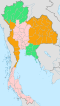
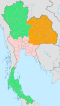
The northern region, as defined by the National Geographical Committee in 1978, consists of nine provinces. Geographically the division, in conformance with the six-region system, includes most of the mountainousnatural region of the Thai highlands.
In 2019 it is common to subdivide the northern region into: nine provinces of the upper northern region and eight provinces of the lower northern region. All websites of these eight provinces state: "located in the lower northern region".
For FY 2018, Northern Thailand Region had a combined economic output of 1,266 trillion baht (US$40.8 billion), or 7.7 percent of Thailand's GDP. Lamphun province had an economic output of 84.395 billion baht (US$2.7 billion). This equates to a GPP per capita of 211,489 baht (US$6,822), half more than for Chiang Mai province, next in the ranking and double than for Lampang province, which is third in the ranking.[9]
Kamphaeng Phet province had an economic output of 117.705 billion baht (US$3.8 billion). This amounts to a GPP per capita of 150,783 baht (US$4,864), half more than for Tak province, which is fifth in the ranking.
Central Thai is the sole official language in Thailand. However, in the six-region classification system, it is the second largest native language in Northern Thailand, amounting to roughly two hundred thousand people, found in the lower part of Uttaradit Province. Central Thai spoken in southern regions of Northern Thailand in the four-region classification system comprise a group of dialects classified as Ne.
1 2 "ตารางที่ 2 พี้นที่ป่าไม้ แยกรายจังหวัด พ.ศ.2562"[Table 2 Forest area Separate province year 2019]. Royal Forest Department (in Thai). 2019. Retrieved 6 April 2021, information, Forest statistics Year 2019, Thailand boundary from Department of Provincial Administration in 2013{{cite web}}: CS1 maint: postscript (link)
↑ รายงานสถิติจำนวนประชากรและบ้านประจำปี พ.ส.2562[Statistics, population and house statistics for the year 2019]. Registration Office Department of the Interior, Ministry of the Interior. stat.bora.dopa.go.th (in Thai). 31 December 2019. Retrieved 26 February 2020.
This page is based on this Wikipedia article Text is available under the CC BY-SA 4.0 license; additional terms may apply. Images, videos and audio are available under their respective licenses.